Current Affairs for UPSC Civil Services Exam – April 04, 2024
Subscribers of "Current Affairs" course can Download Daily Current Affairs in PDF/DOC
Subscribe to Never Miss an Important Update! Assured Discounts on New Products!
Must Join PMF IAS Telegram Channel & PMF IAS History Telegram Channel
{GS1 – Geo – PG – Geomorphology} Pacific Ring of Fire
- Context (IE): Recently, Taiwan faced its strongest earthquake (7.4 magnitude) in 25 years resulting in 9 deaths and over 1,000 injuries.
- The quake’s epicentre was near Hualien County in eastern Taiwan.
- Taiwan is prone to earthquakes due to its position on the Pacific Ring of Fire.
- Over 2,000 earthquakes with magnitudes of 4.0 or higher have been recorded since 1980.
Understanding the Ring of Fire

- The Ring of Fire is a horseshoe-shaped zone containing hundreds of volcanoes and earthquake sites around the Pacific Ocean. It stretches nearly 40,250 kilometres.
- It is the meeting point of numerous tectonic plates, including the Eurasian, North American, Juan de Fuca, Cocos, Caribbean, Nazca, Antarctic, Indian, Australian, Philippine, and other smaller plates,
- It is where tectonic plates converge, causing earthquakes and volcanic activity. 90% of the world’s earthquakes take place here.
- It runs through 15 more countries, including the USA, Indonesia, Mexico, Japan, Canada, Guatemala, Russia, Chile, Peru, and the Philippines.
- Due to their location, these countries face earthquake and volcanic risks.
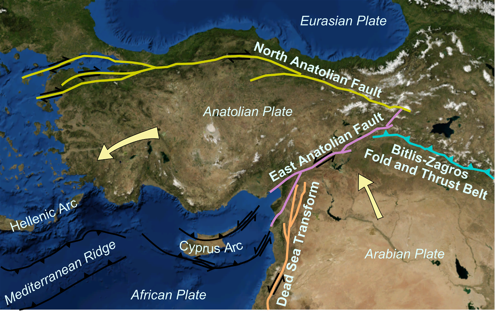
- Taiwan experiences earthquakes due to the interactions between the Philippine Sea Plate and the Eurasian Plate.
What causes Earthquakes?
|
Volcanoes in the Ring of Fire
- Volcanic activity in the Ring of Fire is also due to plate movement, particularly subduction.
- Subduction occurs when heavier tectonic plates are forced beneath one another, leading to the formation of volcanoes.
- When a heavy oceanic plate moves beneath a hotter mantle plate, it heats up. This process causes volatile elements to mix and create magma.
- The magma rises through the Earth’s surface. Eventually, it bursts out, forming volcanoes.
- Most subduction zones are located in the Ring of Fire.
|
Learn more on Earthquakes, Volcanism.
{GS1 – MIH – Events} Perungamanallur Massacre
- Context (TH): Political outfits and leaders paid homage at Perungamanallur village in commemoration of the Perungamanallur massacre’s 104th anniversary.
- Perungamanallur is a village in the Madurai district of Tamil Nadu.
The Massacre
- On April 3, 1920, 16 persons from the Piramalai Kallar community were shot dead, and many others were tortured under detention for their opposition to the Criminal Tribes Act of 1911.
- The black pillar with a burning torch on top in Perungamanallur now stands as a symbol of resistance against the coloniser and his draconian law.
- Britishers used fingerprinting under the Criminal Tribes Act (CTA) to resist the movement of individuals and populations by police suspecting criminality.
- The CTA was initially enacted in 1871, and further amendments gradually toned down the provisions of the Act.
- The Act was repealed after Independence.
{GS2 – MoHFW – Initiatives} myCGHS iOS app
- Context (PIB): Union Health Ministry launches myCGHS iOS app.
- The myCGHS iOS app is developed by the technical teams of the National Informatics Centre (NIC) Himachal Pradesh and NIC Health Team.
- It aims to provide CGHS beneficiaries with convenient access to various healthcare services.
Key Features of the App
- Appointment Management: Users can easily book or cancel appointments online.
- Card Services: Users can download CGHS cards and index cards.
- Lab Reports: Users can access lab reports.
- Medical History: Check medicine history conveniently.
- Claim Status: Track the status of medical reimbursement claims.
- Referral Details: Access referral details for further medical assistance.
- Wellness Centers: Locate nearby wellness centres for quick access to healthcare services.
- News and Highlights: Stay updated with relevant news and highlights in the healthcare sector.
- Hospital Locator: Find nearby empanelled hospitals, labs, and dental units.
- Contact Information: Access contact details of wellness centres and offices.
- Security Measures: The myCGHS app prioritises user data security with features like 2-factor authentication and mPIN functionality, ensuring confidentiality and integrity.
|
{GS3 – Agri – Sustainability} Rice Fallow Management
- Context (DTE): Rice Fallow Management Project initiated by the Odisha government. It sets a precedent for sustainable crop management practices nationally.
- Rice Fallow Management will be a pioneering initiative in regenerative agriculture.
- Eight crops, including green gram, black gram, field pea, Bengal gram, grass pea, lentil, mustard and sesamum, have been targeted under the scheme.
- Central to the success of the rice fallow initiative is the incorporation of a diverse range of eco-friendly agri-inputs.
- It includes bio-fertilisers, bio-pesticides and integrated pest management techniques such as light traps, pheromone traps and blue and yellow sticky traps.
- These measures are designed to promote natural pest control, reduce reliance on chemical pesticides and enhance overall ecosystem health.
What is Rice Fallow Management?
- Rice Fallow Management involves the cultivation of short-duration crops such as pulse and oilseed in rice fallow using the residual moisture left in the soil at the time of rice harvest.
- This is an efficient way of utilising resources for sustainable crop intensification and boosting land productivity.
- Rice fallow, or uncropped land left after rice harvest, is a major agricultural issue in eastern India. Rice Fallow Management helps to address this issue.
Significance
- Enhances crop coverage.
- Reduces soil degradation.
- Optimal utilisation of residual soil moisture.
- Increase soil nutrients through a crop systems approach.
- Improves nutrition security through the consumption of pulses and other crops.
- Effectively utilises the natural resources of the region.
- Potential to increase farmers’ income.
Regenerative Agriculture
- It is a way of farming that builds and improves soil fertility while sequestering and storing atmospheric CO2, increasing farm diversity, and improving water and energy management.

|
{GS3 – IE – Exports} Shrimp Exports
- Context (TH): A report from Corporate Accountability Lab (CAL) alleges human rights and environmental abuses in India’s shrimp farming and processing sector.
- Senior officials asserted the entire value chain for India’s shrimp exports is certified by the Marine Products Export Development Authority (MPEDA), and there is no scope for such concerns.
- In addition, the shrimp value chain is also audited by inspectors from the USFDA, European Commission, and GAC of China, ensuring compliance with international regulations.
India’s Dominance in Shrimp Export Industry
- In 2022-23, India’s seafood exports totalled $8.09 billion, with shrimp comprising $5.6 billion,
- India has emerged as one of the world’s leading shrimp exporters, with its share in the US market increasing from 21% to 40%. India is the largest shrimp supplier to the US.
- Andhra Pradesh hosts around 100,000 shrimp farms, contributing to nearly 70% of India’s shrimp production.
- Approximately 70% of the sector’s 8 million jobs, including 200,000 in hatcheries and aquaculture farms, are held by women.
- The Ministry aims to increase seafood exports to ₹1 lakh crore by 2025-26.
Marine Products Export Development Authority (MPEDA)
|
{GS3 – S&T – AI} AI model testing agreement
- Context (IE): The United States and the United Kingdom signed an agreement to work together to develop tests for the most advanced artificial intelligence (AI) models, effective immediately.
- These commitments were made at the Bletchley Park AI Safety Summit last year.
Bletchley Park
|
- Both countries will share information about capabilities & risks associated with AI models & systems.
- They will also share fundamental technical research on AI safety and security with each other and work on aligning their approach towards safely deploying AI systems.
- They intend to perform at least one joint testing exercise on a publicly accessible model.
For more details, visit > Artificial Intelligence.
{GS3 – S&T – Space} PRATUSH
- Context (TH): ISRO has planned PRATUSH (Probing ReionizATion of the Universe using Signal from Hydrogen).

- It is India’s moon-orbiting radio telescope to be situated on the moon’s far side.
- PRATUSH is being built by the Raman Research Institute (RRI) in Bengaluru and Indian Space Research Organisation (ISRO).
- PRATUSH, as its name denotes, will inform us of the first rays of the first stars in the infant universe
- Initially, ISRO will place PRATUSH into orbit around the earth. After some fine-tuning, the space agency will launch it moonwards.
- It will carry a wideband frequency-independent antenna, a self-calibrating analogue receiver and a digital correlator.
- Objective: Observation of cosmic noise to help understand the evolution of the Universe.
- It seeks to measure the low-frequency radio sky-spectrum over 40 to 200 MHz.
- The nominal lifetime of the payload will be two years.
|
{GS3 – S&T – Space} Telescopes on the Moon
- Context (TH): Astronomers are eager to place high-resolution telescopes on the moon & in its orbit.
Need for such telescopes
- Study the evolution of the Universe: Studying the Dark Age period and observing cosmic hum will enable us to understand the evolution of the Universe.
- Atmospheric obstruction: Optical telescopes and radio telescopes placed on the Earth have to peer through layers of the planet’s atmosphere.
- Interferences: Pollution, radio, and TV signals alter electromagnetic ‘hiss’ from the communications channels used by radar systems, aircraft, and satellites, impacting the observation.
- Earth’s ionosphere: Blocks radio waves coming from outer space.
- Radio signals from Earth: Earth-orbiting radio telescopes also face interference from Earth signals.
- Reduced costs have now intrigued scientists to place telescopes on the far side of the moon.
|
Dark Age of Universe
|
Benefits of telescopes on the far side of the moon
- Crystal-clear observation conditions throughout the long lunar night, which lasts two weeks at a time.
- The moon will blot out radio transmissions from the Earth and electrically charged plasma winds from the Sun.
Moon-bound instruments and telescopes
- Lunar Surface Electromagnetic Experiment (LuSEE Night): This joint NASA-Berkeley Lab project is scheduled to launch in December 2025 and land on the far side of the moon.
- NASA’s Long-Baseline Optical Imaging Interferometer is another such project.
- Argonaut by the European Space Agency (ESA) by 2030.
- Queqiao-2 by China was intended as a communications relay between the Earth and future missions. It has already entered into moon orbit. Its payload includes a 4.2-m antenna that will also be used as a radio telescope.
- PRATUSH radio telescope by India.
{Prelims – Envi – Species} Purple Striped Jellyfish
- Context (TH): Venomous jellyfish blooms have been sighted along the coast of Visakhapatnam in Andhra Pradesh.
- These jellyfish are called Pelagia noctiluca or purple-striped jellyfish.
Jellyfish bloom
- It is when the population of the species increases dramatically within a short period of time, usually due to a higher reproduction rate.
- Reasons: Jellyfish blooms happen because of warm ocean temperatures.
- Effects: These blooms will hurt the fishing and tourism industries.
- Blooms can also occur naturally, often when ocean and wind currents push jellyfish into one area.
Pelagia noctiluca jellyfish

- It is found worldwide in tropical and warm-temperature seas.
- They are rare on the East coast of India.
- Unlike other jellyfish, these jellyfish have stingers not only on their tentacles but also on their bell.
- They are known for their painful sting, which can be life-threatening. If they sting someone, the jellyfish can cause severe pain, vomiting, and diarrhoea.
- These are bioluminescent, having an ability to produce light in the dark.
{Prelims – In News} Harappan site at Padta Bet (Kutch)
- Context (TH): Kerala University researchers unearth evidence shedding light on the Early Harappan settlement in Kutch, Gujrat.
- Location: Small hillock locally called Padta Bet near Khatiya village (Kutch, Gujarat).
- Period: 3,200 BCE to 2,600 BCE.
Findings
- Structural remains: The remains of a circular structure and other rectangular structures of varying sizes, made of locally available sandstone and shales.
- Harappan Ceramics: Belonging to Early Harappan, Classical Harappan, and Late Harappan types.
- Novel ceramics: Reflects the presence of local pottery traditions different from Harappans.
- Animal bone remains: Cattle, sheep, or goat, and edible shell fragments indicate that the inhabitants domesticated animals and exploited shellfish.
- Artefacts: Semi-precious stone beads made of carnelian and agate, terracotta spindle whorls, copper, lithic tools, cores and debitage, grinding stones, and hammer stones.
{Prelims – PIN India} Katchatheevu and Wadge Bank
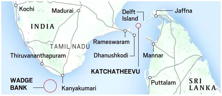
- Context (IE I TH I TNM): In the run-up to the Lok Sabha elections, the BJP and Prime Minister raised the issue of ‘ceding’ Katchatheevu to Sri Lanka in 1974.
- India and Sri Lanka had been claiming Katchatheevu since at least 1921 after a survey placed the island within Sri Lanka’s boundaries.
- In 1974, the two governments signed an agreement and the island was ceded to Sri Lanka.
- After the emergency was imposed in 1975, discussions took place between the foreign secretaries of India and Sri Lanka, and a set of executive orders was issued on the Katchatheevu issue.
- The negotiations settled the maritime boundary between India and Sri Lanka, and Sri Lanka gave India sovereign rights over a maritime patch called ‘Wadge Bank’ near Kanyakumari in 1976.
Wadge Bank
- The India-Sri Lanka agreement of 1976 recognised the Wadge Bank as part of India’s exclusive economic zone, granting India sovereign rights over the area and its resources.
- It is a continental shelf nearly 80 kilometres (50 miles) seaward from the coast of Kanyakumari.
- The Fishery Survey of India has identified the Wadge Bank as a 4,000-sq-mile area bound by 76°.30’ E to 78°.00 E longitude and 7°.00 N to 8° 20’ N latitude.
- Under the agreement, Sri Lankan fishing vessels and personnel were not allowed to engage in fishing activities in the Wadge Bank.
- The agreement allowed Indian fishermen to use the resources in the Wadge Bank area.
- It is a shallow zone with a nearly flat bottom topography and a continental shelf.
- In late 2023, GoI invited Notice Inviting Offers (NIO) under the Hydrocarbon Exploration and Licensing Policy (HELP) for the exploration of oil in Wadge Bank.
- However, residents of the area objected to it, highlighting the area’s importance to fishing communities in Kanyakumari.
Fertile fishing ground
- The bank is rich in biodiversity and a fertile fishing ground. The area around Wadge Bank records the highest organic production on the West Coast.
- It is one of the world’s richest fishing grounds and is in a much more strategic part of the sea than the island of Katchatheevu.
- The low intensity of currents, waves, and tides makes it an ideal location for the accumulation of nutrients and fish food and has less impact on the fish and aquatic animals of this region.
- The Wadge Bank waters are moderate in temperature (26˚-29˚C) but high in salinity ( 35.8 to 36.7% ), supporting many fishery resources.
- This ground’s peak season is from July to October. Upwelling has been reported during the July-September period.
- Fishes prefer this region for feeding and breeding purposes.
Banks
|
What are Hydrocarbons?
- Hydrocarbons are organic compounds made up of hydrogen and carbon atoms.
- They are the fundamental constituents of fossil fuels, including coal, natural gas, and petroleum.
- Hydrocarbon exploration refers to the process of searching for and identifying potential sources of hydrocarbons, such as oil and natural gas, beneath the Earth’s surface.
Government initiatives for hydrocarbon exploration in India
- The Hydrocarbon Exploration and Licensing Policy (HELP) was adopted in 2016.
- Objective: To enhance domestic oil and gas production by intensifying exploration activity and investment.

![PMF IAS Environment for UPSC 2022-23 [paperback] PMF IAS [Nov 30, 2021]…](https://pmfias.b-cdn.net/wp-content/uploads/2024/04/pmfiasenvironmentforupsc2022-23paperbackpmfiasnov302021.jpg)


