
Current Affairs October 15-16, 2023: Regional Comprehensive Economic Partnership, Global Water Resources 2022, State Reorganization
{GS1 – Geo – PG – Climatology} State of Global Water Resources 2022
- Context (DTE): According to the State of Global Water Resources 2022 report by the World Metrological Organisation, climate change has significantly impacted the water cycle.
- The erratic water cycles unleashed widespread disruption, burdening livelihoods and economies.

For more info: Water cycle PMFIAS Physical Geography
Distribution of water on, in, and above the Earth
|

Key Finding of The Reports
- Nearly 4 billion people are experiencing severe water scarcity for at least a month every year.
- A warmer atmosphere holds more moisture, leading to heavier precipitation episodes, flooding, evaporation, dry soils, and intense droughts.
- The Snow Cover in the Alps remained well below the 30-year average during the 2023 spring despite late snowfalls in May, feeding the four major rivers — Rhine, Rhone, Danube and Po.
- The number, total area and volume of glacier lakes have increased rapidly, pushing the lake’s water by approximately 16 Percent of the total volume.
Impact on Asian Water Tower
- The Asian Water Tower (AWT), the world’s largest reservoir of ice and snow after the Arctic and Antarctic regions, saw significant glacial melting in 2022.
- The AWT is a term that refers to the extensive network of high mountain regions across Asia, particularly in countries like India, China, Nepal, Bhutan, and parts of Central Asia.
- These high mountain regions are the source of many major rivers in Asia, such as the Ganges, Brahmaputra, Yangtze, Mekong, Indus, and Amu Darya.
- Glaciers from these mountains supply freshwater to downstream regions, but rising temperatures disrupt this balance, leading to increased precipitation, floods, and severe droughts.
- From 2000-2018, the total glacier mass in the AWT decreased by 4.3 per cent.
- The risks of such glacial events were evident in India as well. North Sikkim witnessed devastating glacial lake outburst floods after the South Lhonak Lake burst in October 2023.

{GS1 – Geo – PG – Geomorphology} Earthquake
- Context (TH): An earthquake near the terminus of the Hindu Kush Mountain range in Afghanistan triggered another earthquake.
Cause of the First Earthquake
- Earthquakes are common in Afghanistan due to active interactions between three tectonic plates, i.e., Arabian, Eurasian, and Indian plates.
- Due to the interaction of these tectonic plates, there are many faultlines in Afghanistan.

- A faultline is a line on a rock surface or the ground that traces a geological fault.
- A fault is a fracture in the Earth’s crust where two blocks of rock move relative to each other.
- If the rock blocks move rapidly, it releases energy, which causes earthquakes.
- The first earthquake was caused by thrust faulting or reverse faulting.
- The term ‘reverse fault’ refers to a situation where the upper block, above the fault plane (hanging wall), moves up and over the lower block, below the fault plane (foot wall).
- Compressional forces cause this reverse fault and cause crust shortening.

How the First Earthquake Triggered the Second Earthquake
- A first quake of 6.3 magnitude was followed by another of the same magnitude.
- This can happen when a fault at one place ruptures resulting in an earthquake that releases stress.
- The release of stress in one fault results in the loading of stress at another fault.
- The loading of stress can trigger another earthquake of same or higher magnitude.
Why it is called the Second Earthquake and Not an Aftershock?
- Aftershocks of relatively lesser magnitude generally follow earthquakes.
- A subsequent seismic event can be called an aftershock when:
- It is smaller in magnitude than the mainshock earthquake.
- It occurs in the same fault zone as the mainshock earthquake
- A subsequent seismic event cannot be called an aftershock when:
- It occurs in a different tectonic plate than the mainshock earthquake.
- It is larger in magnitude than the mainshock earthquake.
- It occurs in a different fault zone than the mainshock earthquake.
Time Limit for Aftershocks
|
||
|
Characteristic |
Aftershock |
Foreshock |
|
Similarities |
||
| Timing | Both occurs after the mainshock earthquake | |
| Magnitude | Both are smaller than the mainshock earthquake | |
| Location | Both occurs within the fault zone | |
|
Differences |
||
| Duration | Last for days, weeks, months, or even years | Typically lasts for a few hours or days |
| Frequency | More common than foreshocks | Less common than aftershocks |
| Causation | A direct response to the stress release caused by the mainshock | An early indication of the stress buildup that ultimately leads to the mainshock |
{GS1 – MIH – Reorganization} State Reorganization
- Context (TH): The DMK will protest to press its demand for statehood for the Puducherry (UT).
- Under Article 3 of IC, the Parliament can make law:
- To form a new State by:
- Separation of territory from any State or
- Uniting two or more States or parts of States
- To increase the area of any State
- To decrease the area of any State
- To change the boundaries of any State
- To change the name of any State
- To form a new State by:
States During British Rule
- During colonial rule, the state boundaries were drawn:
- On administrative convenience, or
- To coincide with the territories annexed by the British government, or
- To coincide with the territories ruled by the princely powers.
- Our national movement rejected artificial divisions and promised linguistic states.
- The Nagpur session of Congress (1920) recognised the linguistic principle as the basis of the reorganization.
- Many Provincial Congress Committees were created by linguistic zones, which did not follow the administrative divisions of British India.
States After Independence
- Things changed after Independence and Partition.
- The fate of the Princely States had not been decided.
- The memory of the partition was still fresh.
- Our leaders felt that carving out states based on language:
- May lead to disruption and disintegration.
- May foster separatism and endanger the unity of the country.
- Hence, they decided to postpone matters of state reorganisation.
- The local leaders and the people challenged this decision of the national leadership. Protests began in different parts of the country for separate states based on language.
Dhar Commission
- In June 1948, the Dhar Commission was appointed on the recommendation of the Drafting Committee of the Constituent Assembly.
- The Commission reported to the Constituent Assembly in December 1948.
- The Dhar Commission report:
- Opposed any reorganization at that time.
- Advised not to create provinces primarily on linguistic grounds.
- The focus should be on administrative convenience when forming provinces.
- Language homogeneity should only be considered as a matter of administrative convenience.
- History, geography, economy, and culture, among other factors, should be considered while making new states.
- Listed specific criteria for creating a province, including:
- Geographical contiguity
- Financial self-sufficiency
- Administrative convenience
- Capacity for future development
- Substantial agreement among the people within its borders regarding its formation.
JVP Committee
- At the Jaipur session in December 1948, INC formed a J.V.P. Committee to look into the matter of linguistic provinces.
- The committee included Jawaharlal Nehru, Sardar Vallabhbhai Patel, and Dr. Pattabhi Sitaramayya.
- The committee advised against following the linguistic principle.
- It recommended that:
- The foremost priority should be India’s security, unity, and economic prosperity.
- The policy of creating linguistic provinces should be applied with caution to avoid conflicts that endanger the country’s stability.
Creation of Andhra State
- The Vishalandhra movement (movement for a separate Andhra) demanded that the Telugu-speaking areas be separated from the Madras province and made into a separate Andhra province.
- Potti Sriramulu, a Congress leader and a veteran Gandhian, went on an indefinite fast, leading to his death after 56 days. This caused great unrest and resulted in violent outbursts in the Andhra region.
- Finally, PM Nehru announced the formation of a separate Andhra state in December 1952.
State Reorganisation Act
- The creation of Andhra Pradesh based on language inspired similar movements in other parts to form states along linguistic lines.
- These struggles increased the pressure on the Central Government to accept their demands.
- The GoI appointed a States Reorganisation Commission (Fazl Ali Commission) in 1953 to look into redrawing the boundaries of states.
- The Commission, in its report (1955), accepted that the state’s boundaries should reflect the boundaries of different languages.
- Based on its report, the States Reorganisation Act was passed in 1956. This led to the creation of fourteen states and six UTs.
|
States |
Union Territories |
|
|
Reorganisation after 1956
- In 1960, Bombay State was divided into Maharashtra and Gujarat.
- In 1966, the state of Punjab was divided into three — Punjab, Haryana, and Himachal Pradesh (HP).
- The mostly Hindi-speaking part became the present-day Indian state of Haryana.
- The mostly Punjabi-speaking part became the present-day Punjab.
- A new union territory (Chandigarh) was also created to serve as the capital of both states.
- Some parts of the former territory of Patiala and East Punjab States Union, including Solan and Nalagarh, were transferred to Himachal Pradesh (HP).
- In 2000:
- Chhattisgarh was created out of eastern Madhya Pradesh.
- Jharkhand was carved out of the southern Bihar.
- Uttaranchal (Uttarakhand) was created out of northwest Uttar Pradesh.
- In 2014, a separate state of Telangana was formed after separating from Andhra Pradesh.
Goa
|
Reorganisation in North-Eastern India
- Nagaland (separating from Assam) became a state in 1963.
- The North-Eastern Areas (Reorganisation) Act of 1971 led to the following changes in 1972:
- Establishment of the states of Manipur and Tripura (earlier, both were UTs).
- Establishment of the state of Meghalaya (Earlier, it was an autonomous part of Assam).
- Establishment of the Union Territories of Mizoram and Arunachal Pradesh.
- Arunachal Pradesh and Mizoram came into being in 1987.
{GS2 – IR – Groupings} Regional Comprehensive Economic Partnership (RCEP)
- Context (TH): Four years after India walked out of the Regional Comprehensive Economic Partnership (RCEP) agreement, neighbours Sri Lanka and Bangladesh are now considering their chances of membership in the 15-nation trading bloc.
- The RCEP is a free trade agreement (FTA) among the Asia-Pacific nations that accounts for about 30% of the world’s population and 30% of global GDP, making it the most significant trade bloc.
- RCEP is the first free FTA among the largest economies in Asia-Pacific countries.
|
- The RCEP was conceived at the 2011 ASEAN Summit in Bali, Indonesia, while negotiations were formally launched during the 2012 ASEAN Summit in Cambodia.
- The treaty was signed in 2020 at the virtual ASEAN Summit hosted by Vietnam.
- For the first ten ratifying countries, the trade pact took effect on 1 January 2022.
- Any country or separate customs territory in the region can accede to the pact from 1 July 2023 onward.


India and RCEP
- India, which took part in the initial negotiations but later decided to opt out, was invited to join the bloc at any time.
Why India Didn’t Join The RCEP In 2019
- Trade Deficit: India’s trade deficit with RCEP countries exceeds $100 billion, with China alone contributing to a $54 billion deficit.
- Data Localisation: India advocated for the right of all RCEP countries to protect data and restrict cross-border data flow in the national interest.
- Dairy Industry: India, a major producer of liquid dairy products, feared an influx of cheap solid dairy products from New Zealand, potentially impacting Indian farmers and dairy entrepreneurs.
- Agriculture: Southern Indian plantation farmers were apprehensive about cheaper imports of tea, coffee, rubber, cardamom and pepper from Malaysia, Indonesia & other RCEP nations.
- Concerns about China: The threat of cheap Chinese goods raised concerns, therefore, India proposed separate customs duty levels for Chinese imports.
- Automatic Trigger Safeguard Mechanism (ATSM): To protect against import surges, India wanted an ATSM that would allow for conditional increases in customs duty on imported products.
- Ratchet Obligation: The RCEP agreement stipulates that commitments cannot be undone. India sought certain exemptions to this rule.
Why should India consider joining RCEP?
- Market Access (2.3 billion people)
- Counterbalancing China and Strategic Alliances
- Attracting Investment
- Technology and Knowledge Transfer
Way forward
- In a world where economic power is shifting toward Asia, India cannot afford to remain on the sidelines. Joining RCEP is the path to harnessing our potential and shaping our destiny.
{GS2 – IR – India-Tanzania} India and Tanzania
- Context (TH): India and Tanzania:
- Announced elevating their ties to a strategic partnership.
- Agreed to expand defence cooperation significantly.
Economic Cooperation
- As per Tanzanian statistics, India is the 3rd largest trade partner after China and UAE.
- In July 2023, India and Tanzania started trade settlements in local currencies, Indian rupees (INR) and Tanzanian shillings.
- The RBI allowed the authorised banks in India to open Special Rupee Vostro Accounts (SRVA) of correspondent banks of Tanzania.
Vostro account
|
Other Significant Developments
- The first International Gandhi Peace Prize in 1995 was awarded to Dr. Julius Nyerere (former President of Tanzania).
- In July 2023, India signed a MoU with Tanzania to establish a branch of IIT Madras in Tanzania. It will be the first IIT branch abroad.
- The government of Tanzania also announced that it would be joining the International Big Cat Alliance and the Global Biofuel Alliance.
H.E. Dr. Samia Suluhu Hassan
|
Alliance vs strategic partnership
|
{GS2 – Polity – IC – Reservation} Cap on Caste-based Reservation
- Context (TH): SC/ST communities currently have a 22.5% reservation, while OBCs have a 27% reservation. The Economically Weaker Section (EWS) has a 10% reservation in government jobs and educational institutions.
- In the original constitution, no express provision for reserving seats in educational institutions existed.
- Governments used Article 46 (DPSP) to formulate reservation policies for educational institutions.
- The government has provided reservations for SCs and STs in educational institutions and jobs by amending Articles 15 and 16.
Article 15(4) of IC
Article 46 of IC
|
- The Mandal Commission report of 1980:
- Estimated OBCs as 52% of India’s population, excluding SCs/STs.
- Recommended 27% reservation for OBCs to keep the overall reservation for SCs, STs and OBCs together below the 50% ceiling set by the SC.
- In Indira Sawhney vs Union of India (1992), the SC:
- Upheld the 50% ceiling on reservations.
- Established factors such as caste, social status, and income to ascertain backwardness.
- Introduced the concept of the ‘creamy layer’ to exclude more wealthy individuals from seeking the benefit of reservations.
|
- The SC, in the EWS quota verdict, said that:
- The 50% ceiling for reservation applies to only SC/ST and OBC (caste-based reservation).
- The 50% ceiling is flexible.
Debate on 50% ceiling on caste-based reservation
- Recently, the Bihar government released the data of its caste survey.
- The data showed that the SCs, STs, and OBCs account for about 84% of the population.
- This has reopened the debate on whether the 50% ceiling on caste-based reservation should be removed.
Arguments in favour of removing the 50% Ceiling
- Many view the 50% ceiling as arbitrary because the judiciary did not have numbers to back that cap.
- Indra Sawhney’s judgment capped reservation at 50%, but it allowed to relax the limit in case of extraordinary or exceptional circumstances.
- The EWS ruling argued that the 50% cap wasn’t rigid.
- The court’s ruling cannot remain constant and irreplaceable. Today, some OBCs are not eligible to enjoy the fruits of the reservation because of the 50% limit.
- Since Indra Sawhney’s judgement, parliament has made several constitutional changes to nullify the effect of the 1992 verdict. Hence, Parliament should consider revising the 50% cap.
- If the 50% ceiling is not removed, many social affirmative actions initiated to eradicate unemployment, discrimination, and other disparities might not be implemented.
Argumenst against removing the 50% Cap
- Permitting the breach of the 50% rule would result in compartmentalisation of classes.
- Removing the 50% limit on reservations will affect the right to equality under Article 14 of IC.
- The rule of equality would be reduced to the right of reservation.
- Affirmative actions are not limited to reservations; hence, a 50% cap won’t limit the state’s power to uplift the backward classes.
- According to Dr Ambedkar, the reservations should be seen as temporary and exceptional, or they could violate the rule of equality.
Article 335 of IC
|
{GS3 – Envi – CC Impact} Arctic Ecosystem Impacts Gray Whale Population
- Context (TH | PHYS): Mass mortality of eastern North Pacific gray whales are occurring due to changing prey biomass and ice cover in the Arctic.
Gray Whales (Eschrichtius robustus)
- Also known as gray-back whale or Pacific gray whale, Korean gray whale, or California gray whale, it is a baleen whale (filters food out of the water using baleen plates).
- Its life expectancy is between 55 and 70 years.
- It was called devil fish because of their fighting behaviour when hunted.
- It is the only whale species that has two blowholes on top of their heads.
- It has a thick layer of blubber that helps them to stay warm in cold water.
- Distribution: It is found in the North Pacific Ocean.
- Habitat: As bottom feeders, gray whales prefer shallow waters near the coast.
- Migration: Grey whales make one of the longest annual migrations of any mammal.
- Eastern Pacific gray whales migrate from the Arctic (feeding ground) to Baja, California, Mexico (breeding ground) in winter.
- Western Pacific gray whales migrate from the Bering Sea and Chukchi Sea (feeding ground) to the coasts of Sakhalin Island (Russia) and China (breeding ground) in winter.
- Conservation Status:
- Eastern North Pacific gray whales: IUCN: Least Concern
- Western North Pacific gray whales: IUCN: Endangered
- North Atlantic gray whales: IUCN: Regionally Extinct
- Threats: Fishing, pollution, and climate change.

Eastern North Pacific Gray Whales: A Conservation Success
- The gray whales were near extinction by 1950 due to commercial hunting.
- Then, they received international & national protection. E.g., Marine Mammal Protection Act (1972).
- As a result, the population eastern North Pacific gray whales recovered and is now least concern species under the IUCN Red List.
Ecological Significance of Gray Whales (GS1, Geo, BG)
- Nutrient Transport: Gray whales consume benthic organisms and excrete nutrients in warmer waters.
- Food Chain: Gray whales feed on small crustaceans and other plankton populations. And gray whales are preyed upon by other large predators.
- Benthic Disturbance: While foraging, gray whales disturb the seafloor. This disturbance can lead to increased biodiversity and habitat for various organisms.
- Tourism: Gray whales support eco-tourism and research, contributing to local economies.
Warming of Arctic and Gray Whales
- Altered Feeding Patterns: Warm waters support less benthic amphipods, gray whale’s primary prey.
- Longer Migration: Diminishing sea ice in the Arctic may prompt gray whales to extend their migration routes. This potentially leads to increased energy expenditure and greater mortality risks.
- Shipping Traffic: Melting sea ice increases shipping traffic in the Arctic.
- Health Issues: Warmer waters may expose gray whales to novel pathogens or toxins.
{GS3 – Envi – Degradation} Thar Desert Dusts Impacting Tibetan Glaciers
- Context (NDTV): Tibetan glaciers are greatly affected by dust from the Thar Desert by reducing albedo of the glaciers.
- Consequence: Due to reduced albedo the glacier absorbs more heat, which causes it to melt faster.

Reasons Why Dusts from Thar Desert Reaches Tibet
- Westerly Wind: The prevailing winds in the region blow from west to east, carrying dust from the Thar Desert over the Tibetan Plateau.
- Atmospheric pressure: The Thar Desert is at a lower elevation than the Tibetan Plateau, so the atmospheric pressure there is lower. This creates a pressure gradient that drives the winds eastward.
Albedo
- Albedo refers to the surface’s ability to reflect light.
- It is represented as a value between 0 and 1, with 0 indicating a surface with no reflection and 1 indicating a surface with complete reflection.
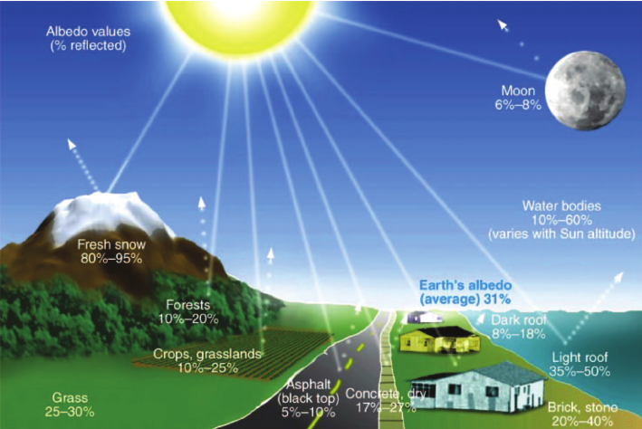

Determinants of Albedo
- Surface Colour: Lighter-colored surfaces have higher albedo as they reflect more light.
- Surface Type and Composition: Fresh snow and ice have high albedo due to their high reflectivity.
- Surface Roughness: Rough surfaces with irregularities can scatter light in multiple directions, leading to lower albedo.
- Sun’s Incidence Angle: Surfaces that receive sunlight at a higher angle (like during midday) have lower albedo as more light is absorbed.
- Surfaces receiving sunlight at a lower angle (like sunrise or sunset) tend to have higher albedo as more light is reflected.
- Surface Condition: Clean, fresh snow has a higher albedo than dirty or compacted snow due to reduced light reflection caused by impurities or ice crystals.
{GS3 – S&T – AI} Lack of Safety Guardrails in AI-Language Models
- Context (TH): French AI firm Mistral’s language model is criticised for its lack of safety guardrails that ChatGPT, Bard and Llama have.
AI Language Model
- It is an artificial intelligence (AI) designed to process and generate natural language text.
- It is a statistical model trained to predict a text’s next word or words based on the preceding words.
- It uses machine learning and deep learning to do so.
Machine Learning
- Machine learning, a subfield of AI, uses algorithms to learn from data and make predictions or decisions without explicitly programmed to do so.
- It entails training a model on an extensive dataset to enable pattern recognition.
Deep Learning
- Deep learning is a subfield of machine learning that is inspired by the structure (neutral networks) and function of the human brain.
- It involves training artificial neural networks on a large dataset so that the network can learn and make intelligent decisions on its own.
Uses of AI Language Models
- Natural Language Processing: To understand and analyse human language (e.g., Siri on iPhones).
- Text generation: To generate texts that resemble human writing (e.g., auto text suggestions on Gmail).
- Language translation: To translate text from one language to another (e.g., Google translator).
- Text classification: To classify text data into different categories. E.g., classifying spam/non-spam emails.
- Dialogue systems: To build chatbots or virtual assistants to engage in user conversations.
- Information retrieval: To search through large volumes of text data and retrieve relevant information.
- Sentiment analysis: To analyse the sentiment of text data. E.g., determining whether a customer review is positive or negative.
Concerns With AI-Language Models Without Safety Guardrails
- Biasness: AI language models can inherit and even exacerbate biases present in their training data, leading to biased or unfair outputs.
- Harmful content: It can be used to generate harmful content, such as hate speech, misinformation, and propaganda.
- Privacy violation: It can generate or process sensitive and private information without users’ consent.
- Manipulation and Deepfakes: It can generate highly convincing text and can be used for malicious purposes, such as creating convincing deepfake text, social engineering, or impersonation attacks.
- Security Risks: It can be exploited for malicious purposes, such as generating phishing emails, spam, or other cyberattacks.
- Inappropriate and restricted content: It can generate inappropriate, offensive, or harmful content. E.g., explanations on how to make explosives.
- AI hallucinations: AI hallucinations refer to a phenomenon where AI systems, particularly LLMs, generate creative and imaginative outputs that are false, nonsensical, or contradictory.
Lobotomy of AI Language Models
- In medicine and neuroscience, a lobotomy is a surgical procedure that involves cutting or disconnecting certain parts of the brain to treat mental disorders.
- Lobotomy of AI language models is a metaphor for the process of restricting or controlling AI language models to prevent them from generating unwanted outputs.
Concerns with Lobotomy of AI-Language Models
- Censorship: Lobotomy can be used to censor AI language models and silence dissent or to suppress unpopular opinions.
- Reduced creativity: Lobotomy can reduce the creativity of AI language models.
- Biasness: It can introduce bias into AI language models.
- Unintended consequences: It can have unintended consequences that are difficult to predict. E.g., filtering social media posts to remove hate speech can also remove legitimate criticism.
Way Forward
- Transparency and accountability: It is important to be transparent about how AI language models are developed and deployed and to be accountable for their outputs.
- Multistakeholder engagement: Safety guardrails for AI language should be developed and implemented with input from a variety of stakeholders, including researchers, developers, users, etc.
- Continuous improvement: As AI language models evolve, it is important to monitor and update safety guardrails continuously.
{GS3 – S&T – Defence} Israel Missile System
- Context (WION I NYP): An Israeli legislator’s calls for using a “doomsday” weapon against Hamas and Palestine have spotlighted nuclear weapons in West Asia, particularly the Jericho missile system.
Jericho Missile System
- The Jericho Missile System is Israel’s inaugural ballistic missile programme launched in the 1960s.
Jericho-1
- It had a range of 500 kilometres and could carry a payload of 1,000 kilograms.
- However, it only had a 50% probability of landing within a 1,000-metre radius of its intended target.
- This model was decommissioned in the 1990s.
Jericho-2
- This model was developed towards the end of the 1980s, ranging from 1,500 to 3,500 km.
Jericho-3
- This model is Israel’s first Intercontinental Ballistic Missile (ICBM).
- It underwent its first test in 2008 and was officially put into service in 2011.
- It is estimated to weigh around 29,000 kg at launch, can carry a payload ranging from 1,000 to 1,300 kg, and has a nuclear warhead weighing around 750 kg.
- It ranges between 4,800 and 6,500 km, using inertial guidance and a radar-guided warhead.
Missiles of Israel
- Israel has one of the Middle East’s most technologically advanced missile arsenals.
- Israel possesses nuclear weapons but is neither a signatory of the Nuclear Non-Proliferation Treaty nor a Missile Technology Control Regime (MTCR) member.
- It has, however, stated a unilateral commitment to abide by MTCR’s restrictions on missile exports.


| Missile Name | Class | Range (km) |
| Gabriel | Anti-Ship Cruise Missile | 35-400 |
| Popeye | Air-Launched Cruise Missile | 75-100 |
| Harpoon | Anti-Ship Cruise Missile | 90-240 |
| EXTRA | Artillery Rocket | 150 |
| Delilah | Land-Attack Cruise Missile | 250-300 |
| LORA | Short-Range Ballistic Missile | 280 |
| Jericho 1 (obsolete) | Short-Range Ballistic Missile | 500 |
| Jericho 2 | Medium-Range Ballistic Missile | 1,500-3,500 |
| Jericho 3 | Intermediate-Range Ballistic Missile | 4,800-6,500 |
Nuclear Non-Proliferation Treaty
Treaty Structure (Three pillars)
Missile Technology Control Regime
|


