 Read MoreWest Flowing Peninsular Rivers: Narmada, Tapti, Sabarmati, Mahi, Luni & Ghaggar
 Read MoreEast Flowing Peninsular Rivers: Cauvery, Pennar, Subarnarekha, Ponnaiyar & Vaigai
 Read MoreEast Flowing Peninsular Rivers: Godavari, Krishna & MahanadiRead MorePeninsular River System vs. Himalayan River System
 Read MoreGanga-Brahmaputra River System: Major Tributaries of The Ganga & Brahmaputra
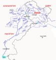 Read MoreIndus River System: Jhelum, Chenab, Ravi, Beas & Satluj
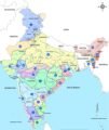 Read MoreClassification of Drainage Systems of India
 Read MoreDrainage patterns: Discordant drainage patterns & Concordant Drainage Patterns
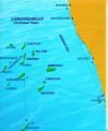 Read MoreIndian Islands: Andaman & Nicobar Islands, Lakshadweep Islands & New Moore Island
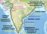 Read MoreCoastline of India | Coastal Plains of India
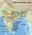 Read MoreHills of Peninsular India: Aravalis, Vindhyas, Satpuras, Western & Eastern Ghats
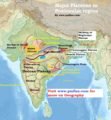 Read MorePeninsular Plateau (Deccan Plateau) | Plateaus in the Peninsular Region
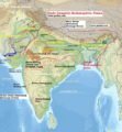 Read MoreDivisions of Indo-Gangetic-Brahmaputra PlainsRead MoreIndo-Gangetic-Brahmaputra Plain | Bhabar, Terai, Bhangar, Khadar
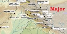 Read MoreMajor Mountain Passes in India & Himalayas