
Coastline of India | Coastal Plains of India
Subscribe to Never Miss an Important Update! Assured Discounts on New Products!
Must Join PMF IAS Telegram Channel & PMF IAS History Telegram Channel
Last updated on April 26, 2024 7:17 PM
Coastline of India (Indian Coastline)
- India has a coastline of 7516.6 Km [6100 km of mainland coastline + coastline of 1197 Indian islands] touching 13 States and Union Territories (UTs).
- The straight and regular coastline of India is the result of faulting of the Gondwanaland during the Cretaceous period. {Continental Drift}
- As such the coast of India does not offer many sites for good natural harbours.
[Indented coastlines of Europe provide good natural harbours whereas African and Indian coastlines are not indented].
- The Bay of Bengal and the Arabian Sea came into being during the Cretaceous or early Tertiary period after the disintegration of Gondwanaland.
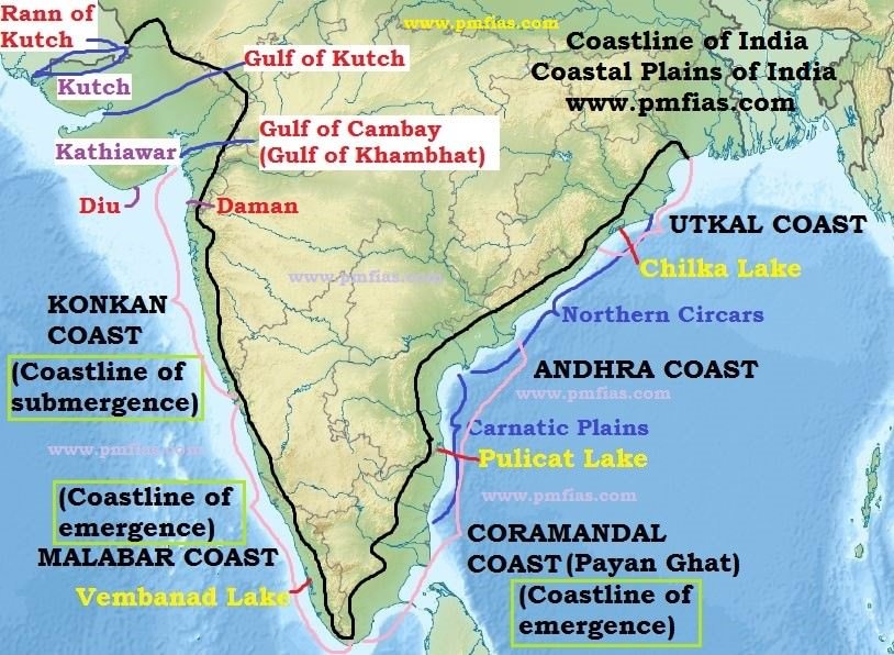
East Coast of India
- Lies between the Eastern Ghats and the Bay of Bengal.
- It extends from the Ganga delta to Kanniyakumari.
- It is marked by deltas of rivers like the Mahanadi, the Godavari, the Krishna and the Cauvery.
- Chilka lake and the Pulicat lake (lagoon) are the important geographical features of east coast.
Regional Names of The East Coast of India
- In Orissa (Odisha) it is known as Utkal coast.
- From the southern limit of the Utkal plain, stretch the Andhra coast.
- In the south of the Andhra plain is the Tamil Nadu coast.
- The Tamil Nadu coast and parts of Andhra coast together are known as Coramandal Coast or Payan Ghat [False Divi Point in AP (Krishna River Delta) in the north to Kanyakumari in the south.].
West Coast of India
- The west coast strip extends from the Gulf of Cambay (Gulf of Khambhat) in the north to Cape Comorin (Kanniyakumari).
- Starting from north to south, it is divided into (i) the Konkan coast, (ii) the Karnataka coast and (iii) the Kerala cost.
- It is made up of alluvium brought down by the short streams originating from the Western Ghats.
- It is dotted with a large number of coves (a very small bay), creeks (a narrow, sheltered waterway such as an inlet in a shoreline or channel in a marsh) and a few estuaries. {Marine Landforms}
- The estuaries, of the Narmada and the Tapi are the major ones.
- The Kerala coast (Malabar Coast) has some lakes, lagoons and backwaters, the largest being the Vembanad Lake.
Regional Names of The West Coast of India
- Konkan coast == Maharashtra coast and Goa coast;
- Malabar Coast == Kerala and Karnataka coast.
Coastlines
Already explained in Marine Landforms. I am discussing here for continuity.
- Coastline of Emergence
- Coastline of Submergence
Coastlines of Emergence and Submergence
- Coastline of emergence is formed either by an uplift of the land or by the lowering of the sea level. Coastline of submergence is an exact opposite case.
- Bars, spits, lagoons, salt marshes, beaches, sea cliffs and arches are the typical features of emergence. {Marine Landforms}
- The east coast of India, especially its south-eastern part (Tamil Nadu coast), appears to be a coast of emergence.
- The west coast of India, on the other hand, is both emergent and submergent.
- The northern portion of the coast is submerged as a result of faulting and the southern portion, that is the Kerala coast, is an example of an emergent coast.
- Coramandal coast (Tamil Nadu) ==> Coastline of emergence
- Malabar coast (Kerala Coast) ==> Coastline of emergence
- Konkan coast (Maharashtra and Goa Coast) ==> Coastline of submergence.
Western Coastal Plains of India
- Rann of Kachchh in the north to Kanniyakumari in the South.
- These are narrow plains with an average width of about 65 km.
Kutch and Kathiawar region
- Kutch and Kathiawar, though an extension of Peninsular plateau (because Kathiawar is made of the Deccan Lava and there are tertiary rocks in the Kutch area), they are still treated as integral part of the Western Coastal Plains as they are now levelled down.
- The Kutch Peninsula was an island surrounded by seas and lagoons. These seas and lagoons were later filled by sediment brought by the Indus River which used to flow through this area. Lack of rains in recent times has turned it into arid and semi-arid landscape.
- Salt-soaked plain to the north of Kutch is the Great Rann. Its southern continuation, known as the Little Rann lies on the coast and south-east of Kachchh.
- The Kathiawar Peninsula lies to the south of the Kachchh. The central part is a highland of Mandav Hills from which small streams radiate in all directions (Radial Drainage). Mt. Girnar (1,117 m) is the highest point and is of volcanic origin.
- The Gir Range is located in the southern part of the Kathiawar peninsula. It is covered with dense forests and is famous as home of the Gir lion.
Gujarat Plain
- The Gujarat Plain lies east of Kachchh and Kathiawar and slopes towards the west and south west.
- Formed by the rivers Narmada, Tapi, Mahi and Sabarmati, the plain includes the southern part of Gujarat and the coastal areas of the Gulf of Khambhat.
- The eastern part of this plain is fertile enough to support agriculture, but the greater part near the coast is covered by windblown loess (heaps of sand).
Konkan Plain
- The Konkan Plain south of the Gujarat plain extends from Daman to Goa (50 to 80 km wide).
- It has some features of marine erosion including cliffs, shoals, reefs and islands in the Arabian Sea.
- The Thane creek around Mumbai is an important embayment (a recess in a coastline forming a bay) which provides an excellent natural harbour.
Karnataka Coastal Plain
- Goa to Mangalore.
- It is a narrow plain with an average width of 30-50 km, the maximum being 70 km near Mangalore.
- At some places the streams originating in the Western Ghats descend along steep slopes and make waterfalls.
- The Sharavati while descending over such a steep slope makes an impressive waterfall known as Gersoppa (Jog) Falls which is 271 m high. [Angel falls (979 m) in Venezuela is the highest waterfall on earth. Tugela Falls (948 m) in Drakensberg mountains in South Africa is the second highest.]
- Marine topography is quite marked on the coast.
Kerala Plain
- The Kerala Plain also known as the Malabar Plain.
- Between Mangalore and Kanniyakumari.
- This is much wider than the Karnataka plain. It is a low lying plain.
- The existence of lakes, lagoons, backwaters, spits, etc. is a significant characteristic of the Kerala coast.
- The backwaters, locally known as kayals are the shallow lagoons or inlets of the sea, lying parallel to the coastline.
- The largest among these is the Vembanad Lake which is about 75 km long and 5-10 km wide and gives rise to a 55 km long spit {Marine Landforms}.
Eastern Coastal Plains of India
- Extending from the Subarnarekha river along the West Bengal-Odisha border to Kanniyakumari.
- A major part of the plains is formed as a result of the alluvial fillings of the littoral zone (relating to or on the shore of the sea or a lake) by the rivers Mahanadi, Godavari, Krishna and Cauvery comprising some of the largest deltas.
- In contrast to the West Coastal Plains, these are extensive plains with an average width of 120 km.
- This plain is known as the Northern Circars between the Mahanadi and the Krishna rivers and Carnatic between the Krishna and the Cauvery rivers.
Utkal Plain
- The Utkal Plain comprises coastal areas of Odisha.
- It includes the Mahanadi delta.
- The most prominent physiographic feature of this plain is the Chilka Lake.
- It is the biggest lake in the country and its area varies between 780 sq km in winter to 1,144 sq km in the monsoon months.
- South of Chilka Lake, low hills dot the plain.
Andhra Plain
- South of the Utkal Plain and extends upto Pulicat Lake. This lake has been barred by a long sand spit known as Sriharikota Island (ISRO launch facility).
- The most significant feature of this plain is the delta formation by the rivers Godavari and Krishna.
- The two deltas have merged with each other and formed a single physiographic unit.
- The combined delta has advanced by about 35 km towards the sea during the recent years. This is clear from the present location of the Kolleru Lake which was once a lagoon at the shore but now lies far inland {Coastline of Emergence}.
- This part of the plain has a straight coast and badly lacks good harbours with the exception of Vishakhapatnam and Machilipatnam.
Tamil Nadu Plain
- The Tamil Nadu Plain stretches for 675 km from Pulicat lake to Kanniyakumari along the coast of Tamil Nadu. Its average width is 100 km.
- The most important feature of this plain is the Cauvery delta where the plain is 130 km wide.
- The fertile soil and large scale irrigation facilities have made the Cauvery delta the granary of South India.
Significance of the Coastal Plains
- Large parts of the coastal plains of India are covered by fertile soils on which different crops are grown. Rice is the main crop of these areas.
- Coconut trees grow all along the coast.
- The entire length of the coast is dotted with big and small ports which help in carrying out trade.
- The sedimentary rocks of these plains are said to contain large deposits of mineral oil (KG Basin).
- The sands of Kerala coast have large quantity of MONAZITE which is used for nuclear power.
- Fishing is an important occupation of the people living in the coastal areas.
- Low lying areas of Gujarat are famous for producing salt.
- Kerala backwaters are important tourist destinations.
- Goa provides good beaches. This is also an important tourist destination.
Primary References: NCERT Geography, Indian Geography by Kullar [Amazon and Flipkart]
Last updated on April 26, 2024 7:17 PM






CHILIKA IS THE BIGGEST BRACKISH WATER LAKE. Biggest lake is wular lake .
Largest fresh water lake- Wular lake.
Largest lake area wise- Chilika lake
Largest lake spreading- vembanad lake
Largest salt make-up chilika lake
Hello sir ..
In explanation , you have stated that the northern end of coromandal coast is False divi point ( krishna delta ) but in Map you pointed coromandal coast’s northern tip up to Godavari delta ..
Now, should we take the map into consideration or explanation into consideration ?
Please suggest sir .. Highly confusing