
Continent-Ocean Convergence, Formation of Fold Mountains
Convergent Boundary
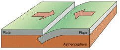
- Along a convergent boundary two lithospheric plates collide against each other.
- When one of the plates is an oceanic plate, it gets embedded in the softer asthenosphere of the continental plate, and as a result, trenches are formed at the zone of subduction.
Convergent Boundary
In convergence there are subtypes namely:
- Collision of oceanic plates or ocean-ocean convergence (formation of volcanic island arcs).
- Collision of continental and oceanic plates or continent-ocean convergence (formation of continental arcs and fold mountains).
- Collision of continental plates or continent-continent convergence (formation of fold mountains)
- Collision of continent and arc, or continent-arc convergence.
Continent-Ocean Convergence or The Cordilleran Convergence
- The concept of Continent-Ocean Convergence is important to understand the formation of the Rockies, the Andes and other similar fold mountain systems.
- Continent-Ocean Convergence is also called Cordilleran Convergence because this kind of convergence gives rise to extensive mountain systems.
- A cordillera is an extensive chain of mountains or mountain ranges. Some mountain chains in North America and South America are called cordilleras.
- Continent-Ocean Convergence is similar to ocean-ocean convergence. One important difference is that in continent-ocean convergence mountains are formed instead of islands.
- When oceanic and continental plates collide or converge, the oceanic plate (denser plate) subducts or plunges below the continental plate (less dense plate) forming a trench along the boundary.
- The trenches formed here are not as deep as those formed in ocean-ocean convergence.
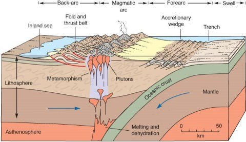
- As the ocean floor crust (oceanic plate) loaded with sediments subducts into the softer asthenosphere, the rocks on the continental side in the subduction zone become metamorphosed under high pressure and temperature (metamorphism: alteration of the composition or structure of rock by heat, pressure).
Formation of Continental Arcs due to Continent-Ocean Convergence
- After reaching a certain depth, plates melt. Magma (metamorphosed sediments and the melted part of the subducting plate) has lower density and is at high pressure.
- It rises due to the buoyant force offered by surrounding denser medium. The magma flows out, sometimes violently to the surface.
- A continuous upward movement of magma creates constant volcanic eruptions at the surface of the continental plate along the margin.
- Such volcanic eruptions all along the boundary form a chain of volcanic mountains which are collectively called as a continental arc. E.g. the Cascade Range (parallel to the Rockies), the Western Chile range (parallel to the Andes)
- Arc: narrow chain of volcanic islands or mountains.
- Island arc: A narrow chain of volcanic islands (Japanese Islands).
- Continental arc: A narrow chain of volcanic mountains on continents (Cascade Range).
- Accretionary wedge: As the oceanic plate subducts, the sediments brought by it accumulates in the trench region. These accumulated sediments are called as accretionary wedge.
- The accretionary wedge is compressed into the continental margin leading to crustal shortening.
- Convergence ==> Crustal Shortening
- Divergence ==> Crustal Widening
- Crustal Shortening at one place is compensated by Crustal Widening in some other place.
Formation of Fold Mountains (Orogeny)
Orogeny (Geology) is a process in which a section of the earth’s crust is folded and deformed by lateral compression (force acting sideways) to form a mountain range.
Orogenic movements are ‘Tectonic movements’ of the earth involve the folding of sediments, faulting and metamorphism (rocks that have transformed by heat, pressure).
- Continental margins are filled with thick sediments brought by the rivers.
- As a result of convergence, the buoyant granite of the continental crust overrides (is placed above) the oceanic crust (continental crust in upthrust by the oceanic crust).
- As a result, the edge of the deformed continental margin is thrust above sea level.
- The advancing oceanic plate adds more compressive stress on the upthrust continental margin and leads to its folding creating a fold mountain system (orogenic belt).
- In some cases, the advancing oceanic plate compresses the orogenic belt leading to its folding (Rockies and Andes).
- With the formation of the orogenic belt (fold mountain belt), resistance builds up which effectively stops convergence. Thus, the subduction zone progresses seaward.
- With the culmination of compression, erosion continues to denude mountains. This results in isostatic adjustment (denser regions sink, and less denser regions rise) which causes the ultimate exposure of the roots of mountains.
- Examples are found in the Rockies, deformed in the late Mesozoic and early Tertiary period, and the Andes, where the deformation began in the Tertiary Period is still going on.
Continent-Ocean Convergence
Formation of the Andes
- The Andes are formed due to convergence between Nazca plate (oceanic plate) and the South American plate (continental plate). Peru-Chile trench is formed due to subduction of Nazca plate.
- The Andes are a continental arc (narrow, continental volcanic chain) formed due to the volcanism above the subduction zone.
- The pressure offered by the accretionary wedge folded the volcanic mountain, raising the mountains significantly.
- The folding process is continuing, and the mountains are constantly rising. Volcanism is still active.
- Ojos del Salado active volcano on the Argentina-Chile border is the highest active volcano on earth at 6,893 m. (Olympus Mons on Mars is the highest volcano in the solar system. It is 26 – 27 km high)
- Mount Aconcagua (6,960 m, Argentina) in the Andes is the highest peak outside the Himalayas and the highest peak in the western hemisphere. It is an extinct volcano.
Western Chile Range (Chilean Coast Range)
- The range was separated from the Andes during the Tertiary rise of the Andes due to the subsidence of the Intermediate Depression.
Formation of the Rockies
- The North American plate (continental plate) moved westwards while the Juan de Fuca plate (minor oceanic plate) and the Pacific plate (major oceanic plate) moved eastwards.
- The convergence gave rise to a series of parallel mountain ranges.
- Unlike the Andes, the Rockies are formed at a distance from the continental margin due to the less steep subduction by the oceanic plates.
- Trenching is less conspicuous as the boundary is filled with accretionary wedge and there are a series of fault zones (San Andreas Fault) that make the landform different from the Andes.
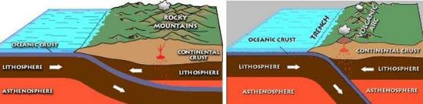
Left: Formation of the Rockies (less steep subduction); Right: Formation of the Andes


sir, which plate is denser… oceanic or continental ??? or is it like that it varies from plate to plate.
Since oceanic plate is basaltic in nature , has less silica content thus lighter ..it should be lighter, however here in this chapter it says that oceanic plate is denser and gets subducted under continental plate?? Please clarify…
The continents are composed of lighter silicates—silica + aluminium (also called ‘sial’) while the oceans have the heavier silicates—silica + magnesium (also called ‘sima’).
https://www.pmfias.com/earths-layers-crust-mantle-core-asthenosphere-earths-composition-crust-composition/
thank you sir, god bless you,doing a great job. I am relying solely on your notes desite being a student of one of the popular coaching institutes….
THANKS A LOT. Amazing Work, Sir!
THANKS A LOT. Amazing Work, Sir!
The quality of these notes are unparalleled. I would say better than Majid Sir’s books.