
Continent-Continent Convergence, Formation of the Himalayas
Subscribe to Never Miss an Important Update! Assured Discounts on New Products!
Must Join PMF IAS Telegram Channel & PMF IAS History Telegram Channel
Convergent Boundary
- Along a convergent boundary two lithospheric plates collide against each other.
- When one of the plates is an oceanic plate, it gets embedded in the softer asthenosphere of the continental plate, and as a result, trenches are formed at the zone of subduction.
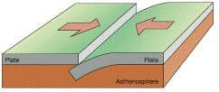
Convergent Boundary
In convergence there are subtypes namely:
- Collision of oceanic plates or ocean-ocean convergence (formation of volcanic island arcs).
- Collision of continental and oceanic plates or ocean-continent convergence (formation of continental arcs and fold mountains).
- Collision of continental plates or continent-continent convergence (formation of fold mountains)
- Collision of continent and arc, or continent-arc convergence.
Continent-Continent Convergence or The Himalayan Convergence
Understanding Continent-Continent Convergence is important to understand the Formation of the Himalayas, the Alps, the Urals and the Atlas Mountains.
- In ocean-ocean convergence and continent-ocean convergence, at least one of the plates is denser and hence the subduction zone is quite deep (few hundred kilometres).
- In Continent-Continent Convergence, at continent-continent convergent margins, due to lower density, both of the continental crustal plates are too light (buoyant) to be carried downward (subduct) into a trench.
- In most cases, neither plate subducts or even if one of the plates subducts, the subduction zone will not go deeper than 40 – 50 km. The two plates converge, buckle up (suture zone), fold, and fault.
- As the continental plates converge, the ocean basic or a sedimentary basin (geoclinal or geosynclinal sediments found along the continental margins) is squeezed between the two converging plates.
- Huge slivers of rock, many kilometres wide are thrust on top of one another, forming a towering mountain range.
- With the building up of resistance, convergence comes to an end. The mountain belt erodes, and this is followed by isostatic adjustment.
- As two massive continents weld, a single large continental mass joined by a mountain range is produced.
- Examples: The Himalayas, Alps, Urals, Appalachians and the Atlas Mountains.
Suture zone: The subduction of the continental crust is not possible beyond 40 km because of the normal buoyancy of the continental crust. Thus, the fragments of oceanic crust are plastered against the plates causing welding of two plates known as suture zone. Example: The Indus-Tsangpo suture zone.
Formation of the Himalayans and the Tibetan Plateau due to Continent-Continent Convergence
- The Himalayas are the youngest mountain chain in the world.
- Himalayan mountains have come out of a great geosyncline called the Tethys Sea and that the uplift has taken place in different phases.
- During Permian Period (250) million years ago, there was a supercontinent known as Pangaea.
- Its northern part consisted of the present-day North America and Eurasia (Europe and Asia) which is called as Laurasia or Angaraland or Laurentia.
- The southern part of Pangaea consisted of present-day South America, Africa, South India, Australia and Antarctica. This landmass was called Gondwanaland.
- In between Laurasia and Gondwanaland, there was a long, narrow and shallow sea known as the Tethys Sea (all this was explained earlier in Continental Drift Theory).
- There were many rivers which were flowing into the Tethys Sea (some of the Himalayan rivers were older than the Himalayas themselves. We will study this in Antecedent and Subsequent Drainage).
- Sediments were brought by these rivers and were deposited on the floor of the Tethys Sea.
- These sediments were subjected to powerful compression due to the northward movement of the Indian Plate. This resulted in the folding of sediments.
- An often-cited fact used to illustrate this process is that the summit of Mount Everest is made of marine limestone from this ancient ocean.
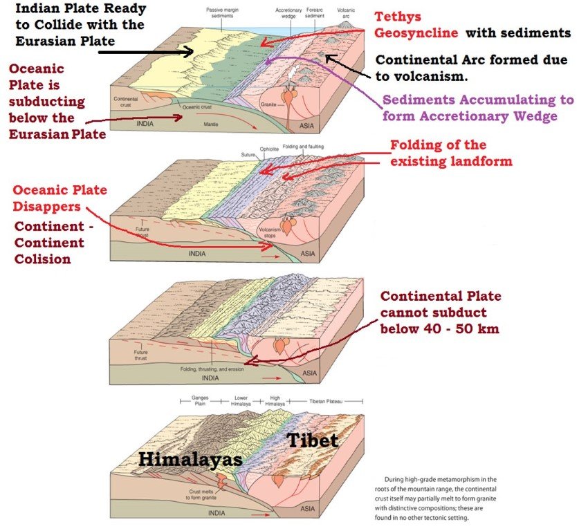
- Once the Indian plate started plunging below the Eurasian plate, these sediments were further folded and raised. This process is still continuing (India is moving northwards at the rate of about five cm per year and crashing into rest of Asia).
- And the folded sediments, after a lot of erosional activity, appear as the present-day Himalayas.
- Tibetan plateau was formed due to upthrusting of the southern block of the Eurasian Plate.
- The Indo-Gangetic plain was formed due to the consolidation of alluvium brought down by the rivers flowing from the Himalayas.
- The curved shape of the Himalayas convex to the south is attributed to the maximum push offered at two ends of the Indian Peninsula during its northward drift.
Phases of formation
- The Himalayas do not comprise a single range but a series of at least three ranges running more or less parallel to one another.
- Therefore, the Himalayas are supposed to have emerged out of the Himalayan Geosyncline, i.e. the Tethys Sea in three different phases following one after the other.
- The first phase commenced about 50-40 million years ago when the Great Himalayas were formed. The formation of the Great Himalayas was completed about 30 million years ago.
- The second phase took place about 25 to 30 million years ago when the Middle Himalayas were formed.
- The Shiwaliks were formed in the last phase of the Himalayan orogeny — say about two million to twenty million years ago.
- Some of the fossil formations found in the Shiwalik hills are also available in the Tibet plateau. It indicates that the past climate of the Tibet plateau was somewhat similar to the climate of the Shiwalik hills.
Recent studies have shown that convergence of the Indian plate and the Asian plate has caused a crustal shortening of about 500 km in the Himalayan region. This shortening has been compensated by seafloor spreading along the oceanic ridge in the Indian Ocean.
Evidence for the rising Himalayas
- Today’s satellites that use high precision atomic clocks that can measure accurately even a small rise of one cm. The heights of various places as determined by satellites indicate that the Himalayas rise by few centimetres every year. The present rate of uplift of the Himalayas has been calculated at 5 to 10 cm per year.
- Due to uplifting, lakes in Tibet are desiccated (lose water) keeping the gravel terraces at much higher levels above the present water level. This could be possible only in the event of uplift of the region.
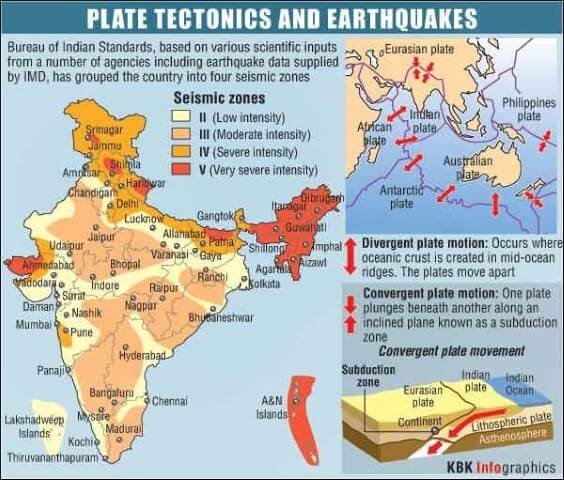
- The frequent tectonic activity (occurrence of earthquakes) in the Himalayan region shows that the Indian plate is moving further northwards and plunging into the Eurasian plate.
- This means that the Himalayas are still being raised due to compression and have not yet attained isostatic equilibrium.
- The Himalayan rivers are in their youthful stage and have been rejuvenated (make or cause to appear younger) in recent times. This shows that the Himalayan Landmass is rising, keeping the rivers in youth stage since a long time.
Formation of Alps, Urals, Appalachians and the Atlas Mountains
- The formation of each of these mountains is similar to the formation of the Himalayas.
- The Alps are young fold mountains which were formed due to the collision between African Plate and the Eurasian Plate.
- The Atlas Mountains are also young folded mountains which are still in the process of formation. They are also formed due to the collision between African Plate and the Eurasian Plate.
- The Urals are very old fold mountains which were formed even before the breakup of Pangaea. They were formed due to the collision between Europe and Asia.
- The Appalachians are also very old fold mountains which were formed even before the breakup of Pangaea. They were formed due to the collision between North America and Europe.
Volcanism and Earthquakes in Continent-Continent Convergence
- Oceanic crust is only 5 – 30 km thick. But the continental crust is 50 – 70 km thick. Magma cannot penetrate this thick crust, so there are no volcanoes, although the magma stays in the crust.
- Metamorphic rocks are common because of the stress the continental crust experiences.
- With enormous slabs of crust smashing together, continent-continent collisions bring on numerous and large earthquakes (Earthquakes in Himalayan and North Indian Region, Kachchh region).
UPSC CSE Mains 2014 Question on Fold Mountains
Why are the world’s fold mountain systems located along the margins of continents? Bring out the association between the global distribution of Fold Mountains and the earthquakes and volcanoes.
Why fold mountains at the continental margin?
- Fold mountains are formed due to convergence between two continental plates (Himalayas, Alps) or between an oceanic and a continental plate (the Rockies, Andes).
- In Continent-Continent (C-C) convergence, oceanic sediments are squeezed and up thrust between the plates and these squeezed sediments appear as fold mountains along the plate margins.
- In Continent-Ocean (C-O) convergence, the continental volcanic arc formed along the continental plate margin is compressed and is uplifted by the colliding oceanic plate giving rise to fold mountains along the continental plate margin.
Earthquakes
- In both C-C convergence and C-O convergence, there is the formation of fold mountains and frequent occurrence of earthquakes.
- This is because of the sudden release of friction between the subducting plate and up thrust plate.
- In C-C convergence, the denser plate pushes into the less dense plate creating a fault zone along the margin.
- Further collision leads to the sudden release of energy along this fault zone generating disastrous earthquakes (shallow-focus earthquakes).
- In C-O regions the subducting oceanic plate grinds against the surrounding denser medium producing mostly shallow-focus earthquakes, and deep in the subduction zone deep-focus earthquakes occur.
- Volcanism is observed only in C-O convergence and is almost absent in C-C convergence.
Volcanism
- This is because of the thick continental crust in C-C convergence which prevents the outflow of magma. Magma here lies stocked within the crust.
- In C-O convergence, metamorphosed sediments and melting of the subducting plate form magma which escapes to the surface through the less thick continental crust.
Continent-Arc Convergence or New Guinea Convergence
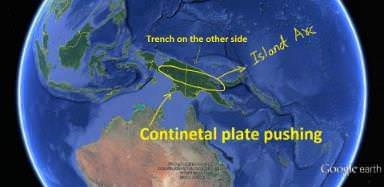
- New Guinea came into being about 20 million years ago as a result of continent-arc collision.
- The continental plate pushes the island arc towards the oceanic crust. The oceanic plate plunges under the island arc.
- A trench occurs on the ocean side of the island arc and, ultimately, the continental margin is firmly welded against the island arc.














wonderful explanation sir…
Thanks man
Sir when notes for environment and ecology will be uploaded?
And agri geography?
Uploaded
sir your notes of geography is sufficiant for upsc exam
incomplete compilation of standard books……….read standard books for upsc