
Tropical Cyclones: Favorable Conditions, Formation & Structure
- Cyclone Montha is moving north-northwest across the west-central Bay of Bengal toward making landfall along the Kakinada coast in Andhra Pradesh.
What are Tropical Cyclones?
- A Tropical Cyclone is a large, non-frontal low-pressure system that forms over tropical or subtropical waters. It is characterised by organised thunderstorm activity and a closed cyclonic wind circulation around a central calm region known as the eye.
- These rotating wind systems form due to the rapid upward movement of warm, moist air, influenced by the Coriolis force, which causes anticlockwise rotation in the Northern Hemisphere and clockwise in the Southern Hemisphere.

- The cyclones are often characterised by the existence of an anticyclone between two cyclones.
|
Favourable Conditions for Tropical Cyclone Formation
- Large sea surface with temperature higher than 27° C (Ocean waters having temperatures of 27° C or more are the source of moisture, which feeds the storm. The condensation of moisture releases enough latent heat of condensation to drive the storm).
- Presence of the Coriolis force enough to create a cyclonic vortex.
- Small variations in the vertical wind speed.
- A pre-existing weak low-pressure area or low-level cyclonic circulation.
- Upper divergence above the sea level system.
Latent Heat
- Ocean waters having temperatures of 27° C or more is the source of moisture which feeds the storm. The condensation of moisture releases enough latent heat of condensation to drive the storm.
Coriolis Force
- The Coriolis force is zero at the equator (no cyclones at the equator because of zero Coriolis Force), but it increases with latitude.
- Coriolis force at 5° latitude is significant enough to create a storm [cyclonic vortex].
- ~65 per cent of cyclonic activity occurs between 10° and 20° latitude.

Low-level Disturbances
- Low-level disturbance is a low-pressure trough (an extended region of low pressure associated with extensive cloud formation and numerous thunderstorms) that moves from east to west in the form of easterly wave disturbances in the Inter-Tropical Convergence Zone (ITCZ).
- Easterly wave disturbances act as seedling circulations (birthplace) for a large number of tropical cyclones. However, not all disturbances develop into cyclones.
|
Temperature Contrast between Air Masses
- The convergence of air masses of different temperatures results in instability causing low-level disturbances (low-pressure cells) which are a prerequisite for the origin and growth of violent tropical storms.
- Trade winds from both hemispheres meet along the Inter-Tropical Front (ITCZ). Temperature contrasts between these air masses must exist when the ITCZ is farthest from the equator so that the low-level disturbances can intensify into a depression (intensifying low-pressure cell).
Upper Air Disturbance
- The remains of an upper tropospheric cyclone from the Westerlies move deep into the tropical latitude regions. As divergence prevails on the eastern side of the troughs, a rising motion occurs; this leads to the development of thunderstorms.
- Further, these old abandoned troughs (remnants of temperate cyclones) usually have cold cores, suggesting that the environmental lapse rate is steeper and unstable below these troughs. Such instability encourages thunderstorms (child cyclones).

Wind Shear
- Vertical Wind Shear is the difference between wind speeds at different altitudes.
- Tropical cyclones develop when the vertical wind shear is low. High wind shear inhibits the development of towering cumulonimbus clouds and the cyclonic vortex.
Upper Tropospheric Divergence
- A well-developed divergence in the upper layers of the atmosphere is necessary so that the rising air currents within the cyclone continue to be pumped out and a low pressure is maintained at the centre.
Humidity Factor
- High humidity (around 50 to 60 per cent) is required in the mid-troposphere, since the presence of moist air leads to the formation of cumulonimbus cloud.
- Such conditions exist over the equatorial doldrums, especially in western margins of oceans (this is because of east to west movement of ocean currents), which have great moisture, carrying capacity because the trade winds continuously replace the saturated air.
Formation of Tropical Cyclones
- The tropical cyclones have a thermal origin, and they develop over tropical seas during late summers (August to mid-November).
- At these locations, the strong local convectional currents acquire a whirling motion because of the Coriolis force.
- After developing, these cyclones advance till they find a weak spot in the trade wind belt.

Origin
- Under favourable conditions, multiple thunderstorms originate over the oceans. These thunderstorms merge and create an intense low-pressure system (wind is warm and lighter).

Early Stage
- In the thunderstorm, air is uplifted as it is warm and light. At certain height, due to lapse rate and adiabatic lapse rate, the temperature of air falls and moisture in the air undergoes condensation.
- Condensation releases latent heat of condensation making the air more warmer. It becomes much lighter and is further uplifted.
- The space is filled by fresh moisture laden air. Condensation occurs in this air and the cycle is repeated as long as the moisture is supplied.
- Due to excess moisture over oceans, the thunderstorm intensifies and sucks in air at a much faster rate. The air from the surroundings rushes in and undergoes deflection due to the Coriolis force, creating a cyclonic vortex (spiralling air column similar to a tornado).
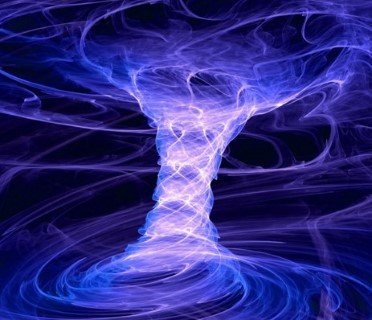
- Due to centripetal acceleration (centripetal force pulling towards the center is countered by an opposing force called centrifugal force), the air in the vortex is forced to form a region of calmness called an eye at the center of the cyclone. The inner surface of the vortex forms the eye wall, the most violent region of the cyclone.
[Eye is created due to the tangential force acting on the wind that is following a curvy path]

- All the wind that is carried upwards loses its moisture and becomes cold and dense. It descends to the surface through the cylindrical eye region and at the edges of the cyclone.
- Continuous supply of moisture from the sea is the major driving force behind every cyclone. On reaching the land the moisture supply is cut off and the storm dissipates.
- If ocean can supply more moisture, the storm will reach a mature stage.
Mature Stage
- At this stage, the spiralling winds create multiple convective cells with successive calm and violent regions.
- The regions with cumulonimbus cloud (rising limbs of convective cell) formation are called rain bands, below which intense rainfall occurs.
- The ascending air will lose moisture at some point and descend (subsides) back to the surface through the calm regions (descending limbs of convection cell – subsiding air) that exist between two rain bands.
- Cloud formation is dense at the center. The cloud size decreases from the center to the periphery.
- Rain bands are mostly made up of cumulonimbus clouds. The ones at the periphery are made up of nimbostratus and cumulus clouds.
- The dense overcast at the upper levels of troposphere is due to cirrus clouds which are mostly made up of hexagonal ice crystals.
- The dry air flowing along the central dense overcast descends at the periphery and the eye region.

Why Cyclones Form Mostly on Western Ocean Margins?
- Tropical cyclones are common on western sides of tropical oceans — for example, the Bay of Bengal, Caribbean Sea, and Philippine Sea, because warm ocean currents move from east to west under the influence of trade winds. This causes a thick layer of warm water (≥27°C) in western parts, providing energy and moisture.
- Eastern ocean margins have cold currents, which lower surface temperature and inhibit cyclone formation.
|
Why Cyclones Occur Mostly in Late Summer?
- Due to the high specific heat of water and mixing, ocean waters in the Northern Hemisphere reach their maximum temperatures in August. (Continents attain maximum temperatures in June-July).
- Whirling motion is enhanced when the doldrums (region within ITCZ) over oceans are farthest from the equator. This happens during the autumnal equinox (August-September). At this time, there are two advantages: the air is overheated and the sun is exactly over the equator.
Structure of Tropical Cyclone

Eye
- The “eye” is a roughly circular area of comparatively light winds and fair weather found at the center of a severe tropical cyclone.
- There is little or no precipitation, and sometimes blue sky or stars can be seen.
- The eye is the region of lowest surface pressure and warmest temperatures aloft (in the upper levels) – the eye temperature may be 10°C warmer or more at an altitude of 12 km than the surrounding environment, but only 0-2°C warmer at the surface in the tropical cyclone.
- Eyes range in size from 8 km to over 200 km across, but most are approximately 30-60 km in diameter.

Eye Wall
- The eye is surrounded by the “eye wall”, the roughly circular ring of deep convection, which is the area of highest surface winds in the tropical cyclone. Eye Wall region also sees the maximum sustained winds i.e. fastest winds in a cyclone occur along the eye wall region.
- The eye is composed of air that is slowly sinking and the eye wall has a net upward flow as a result of many moderate – occasionally strong – updrafts and downdrafts.
- The eye’s warm temperatures are due to compressional warming (adiabatic) of the subsiding air.
- Most soundings taken within the eye show a low-level layer, which is relatively moist, with an inversion above – suggesting that the sinking in the eye typically does not reach the ocean surface, but instead only gets to around 1-3 km of the surface.
Spiral Bands
- Another feature of tropical cyclones that probably plays a role in forming and maintaining the eye is the eye wall convection.
- Convection in tropical cyclones is organised into long, narrow rain bands, which are oriented in the same direction as the horizontal wind.
- Because these bands seem to spiral into the center of a tropical cyclone, they are called “spiral bands”.
- Along these bands, low-level convergence is a maximum, and therefore, upper-level divergence is most pronounced above.
- A direct circulation develops in which warm, moist air converges at the surface, ascends through these bands, diverges aloft, and descends on both sides of the bands.
- Subsidence is distributed over a wide area on the outside of the rain band but is concentrated in the small inside area.
- As the air subsides, adiabatic warming takes place, and the air dries.
- Because subsidence is concentrated on the inside of the band, the adiabatic warming is stronger inward from the band, causing a sharp contrast in pressure falls across the band since warm air is lighter than cold air.
- Because of the pressure that falls on the inside, the tangential winds around the tropical cyclone increase due to the increased pressure gradient. Eventually, the band moves toward the center and encircles it and the eye and eye wall form.
- Thus, the cloud-free eye may be due to a combination of dynamically forced centrifuging of mass out of the eye into the eye wall and to a forced descent caused by the moist convection of the eye wall.
Vertical Structure of a Tropical Cyclone
| Layer | Altitude | Function |
|---|---|---|
| Inflow Layer | 0–3 km | Warm, moist air drawn in from surroundings |
| Cyclonic Core | 3–7 km | Main storm activity (rising convection) |
| Outflow Layer | Above 7 km | Air diverges outward (anticyclonic flow) |
- At about 12 km, strong outflow at the top helps maintain the cyclone’s low pressure at the surface.
Characteristics of Tropical Cyclones
Size and Shape
- Tropical cyclones have symmetrical elliptical shapes (2:3 ratio of length and breadth) with steep pressure gradients. They have a compact size—80 km near center, which may develop up to 300 km to 1500 km.
Wind Velocity and Strength
- Wind velocity, in a tropical cyclone, is more in poleward margins than at center and is more over oceans than over landmasses, which are scattered with physical barriers. The wind velocity may range from nil to 1200 km per hour.
Path of Tropical Cyclones
- These cyclones start with a westward movement, but turn northwards around 20° latitude. They turn further north-eastwards around 25° latitude, and then eastwards around 30° latitude. They then lose energy and subside.
- Tropical cyclones follow a parabolic path, their axis being parallel to the isobars.
- Coriolis force or the Earth’s rotation, easterly and westerly winds influence the path of a tropical cyclone.
- Tropical cyclones die at 30° latitude because of cool ocean waters and increasing wind shear due to westerlies.

Factors Influencing Movement of Cyclones
Atmospheric Circulation Influences
- Steering Effect: Cyclones move along the prevailing path of mid and upper troposphere winds (5-10 km), where large-scale horizontal atmospheric flow influences their speed and direction.
- Trade Winds: Easterly (east-to-west) trade winds in tropical regions steer cyclones westward, pushing them toward the eastern coasts of continents.
- Example: Bay of Bengal cyclones commonly make landfall along India’s eastern coast.
- Westerlies Influence: Mid-latitude (30°-60°) westerly winds (west-to-east) steer poleward-moving mature cyclones toward the northeast.
- Example: Atlantic hurricanes initially drift north from the tropics, then turn northeast toward Europe.
- Coriolis Effect: Earth’s rotation deflects moving air in cyclones counterclockwise in the Northern Hemisphere and clockwise in the Southern Hemisphere, causing a slight poleward-westward beta drift.
Monsoon Wind Systems
- Southwest Monsoon: Southwest monsoon winds during June-September direct Arabian Sea cyclones north-eastward toward India’s western coast, especially Gujarat and Maharashtra.
- Northeast Monsoon: Northeast monsoon winds from October to December drive Arabian Sea cyclones westward toward the Arabian Peninsula and the eastern African coast.
Pressure Systems and Interactions
- Subtropical Ridge: Strong high-pressure ridges act as atmospheric barriers, forcing cyclones to deflect around or move along their boundaries.
- Example: The Bermuda-Azores High steers Atlantic cyclones westward toward the Caribbean or the southeastern US.
- Trough Interaction: Westerly troughs in mid-latitudes create low-pressure corridors that attract cyclones poleward and then north-eastward.
- Example: Arabian Sea cyclones often recurve northward toward India under their influence.
- Fujiwhara Effect: Two nearby cyclones rotate around a shared centre, mutually altering their path and speed through angular momentum exchange.
Categories of Tropical Cyclones

Regional Names & Breeding Grounds for Tropical Cyclones
| Region | Local Name |
|---|---|
| Indian Ocean | Cyclones |
| Atlantic Ocean | Hurricanes |
| Western Pacific / South China Sea | Typhoons |
| Western Australia | Willy-willies |
Major Breeding Grounds
- Bay of Bengal & Arabian Sea
- Western Pacific (Philippines, Japan)
- Caribbean & Gulf of Mexico
- Madagascar–Mauritius region
- North-west Australia


This is the best source…. Thank You
In the video, there is a question in which the statement – “Wind pattern is Clockwise in Northern Hemisphere….”, is incorrect as mentioned in the video.
Had it been “Anti-clockwise in Northern Hemisphere”, it would have been correct.
But how can any of the above options be correct since Clockwise/Anticlockwise depends on:
1. the wind pattern itself (cyclone/anticyclone)
2. or the direction from which we are looking (equator/north pole)
Is there something such as ‘default’ wind pattern/direction here? (Specific question wrt confusing options in prelims)
The explanation is v good. It clears all the doubts arising for tropical cyclones .Thanks a ton.
Thank you so much…..this is the very helpful source ….clear lot of concepts
Thank you so much…..this is the very helpful source ….clear lot of concepts