Air expands when heated and gets compressed when cooled. This results in variations in the atmospheric pressure.
The differences in atmospheric pressure causes the movement of air from high pressure to low pressure, setting the air in motion. Atmospheric pressure also determines when the air will rise or sink.
Air in horizontal motion is wind. The wind redistributes the heat and moisture across latitudes, thereby, maintaining a constant temperature for the planet as a whole.
The vertical rising of moist air forms clouds and bring precipitation.
Air Pressure
Since air has mass, it also has weight. The pressure of air at a given place is defined as a force exerted in all directions by virtue of the weight of all the air above it.
The weight of a column of air contained in a unit area from the mean sea level to the top of the atmosphere is called the atmospheric pressure. The atmospheric pressure is expressed in various units.
Measurement of Air Pressure
Atmospheric pressure is the weight of the column of air at any given place and time. It is measured by means of an instrument called barometer.
The units used by meteorologists for this purpose are called millibars (mb).
One millibar is equal to the force of one gram on a square centimeter. A pressure of 1000 millibars is equal to the weight of 1.053 kilograms per square centimeter.
In other words, it will be equal to the weight of a column of mercury 75 cm high.
The normal pressure at sea level is taken to be about 76 centimeters (1013.25 millibars).
Vertical Variation of Pressure
In the lower atmosphere the pressure decreases rapidly with height.
At the height of Mt. Everest, the air pressure is about two-thirds less than what it is at the sea level.
The decrease in pressure with altitude, however, is not constant. Since the factors controlling air density – temperature, amount of water vapour and gravity are variable, there is no simple relationship between altitude and pressure.
In general, the atmospheric pressure decreases on an average at the rate of about 34 millibars every 300 metres of height.
The vertical pressure gradient force is much larger than that of the horizontal pressure gradient. But, it is generally balanced by a nearly equal but opposite gravitational force. Hence, we do not experience strong upward winds.
Due to gravity the air at the surface is denser and hence has higher pressure. Since air pressure is proportional to density as well as temperature, it follows that a change in either temperature or density will cause a corresponding change in the pressure.
The pressure decreases with height. At any elevation it varies from place to place and its variation is the primary cause of air motion, i.e. wind which moves from high pressure areas to low pressure areas.
A rising pressure indicates fine, settled weather, while a falling pressure indicates unstable and cloudy weather.
Horizontal Distribution of Pressure
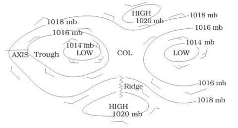
Small differences in pressure are highly significant in terms of the wind direction and velocity. Horizontal distribution of pressure is studied by drawing isobars at constant levels.
Isobars are lines connecting places having equal pressure. In order to eliminate the effect of altitude on pressure, it is measured at any station after being reduced to sea level for purposes of comparison.
The spacing of isobars expresses the rate and direction of pressure changes and is referred to as pressure gradient.
Close spacing of isobars indicates a steep or strong pressure gradient, while wide spacing suggests weak gradient. The pressure gradient may thus be defined as the decrease in pressure per unit distance in the direction in which the pressure decreases most rapidly.
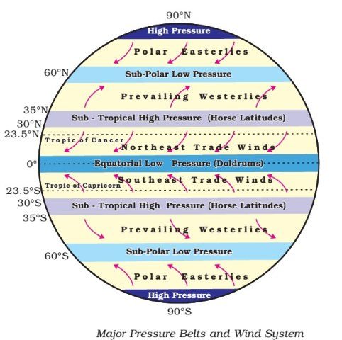
There are distinctly identifiable zones of homogeneous horizontal pressure regimes or ‘pressure belts’. On the earth’s surface, there are in all seven pressure belts.
The seven pressure belts are :
equatorial low,
the sub-tropical highs,
the sub-polar lows, and
the polar highs.
Except the equatorial low, all others form matching pairs in the northern and southern hemispheres.
Closed Isobars or Closed Pressure centers
Low pressure system is enclosed by one or more isobars with the lowest pressure in the centre. High-pressure system is also enclosed by one or more isobars with the highest pressure in the centre.
World Distribution of Sea Level Pressure
The atmosphere exerts a pressure of 1034 gm per square cm at sea level. This amount of pressure is exerted by the atmosphere at sea level on all animals, plants, rocks, etc.
Near the equator the sea level pressure is low and the area is known as equatorial low. Along 30° N and 30° S are found the high-pressure areas known as the subtropical highs. Further pole wards along 60° N and 60° S, the low-pressure belts are termed as the sub polar lows. Near the poles the pressure is high and it is known as the polar high.
These pressure belts are not permanent in nature. They oscillate with the apparent movement of the sun. In the northern hemisphere in winter they move southwards and in the summer northwards.
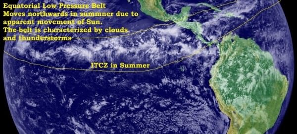
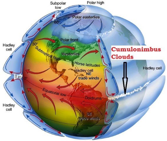
Equatorial Low Pressure Belt or ‘Doldrums’
Lies between 10°N and 10°S latitudes.
Width may vary between 5°N and 5°S and 20°N and 20°S.
This belt happens to be the zone of convergence of trade winds from two hemispheres from sub-tropical high pressure belts.
This belt is also called the Doldrums, because of the extremely calm air movements.
The position of the belt varies with the apparent movement of the Sun.
Formation
As this region lies along the equator, it receives highest amount of insolation.
Due to intense heating, air gets warmed up and rises over the equatorial region (convection).
Whenever there is vertically upward movement of air, the region at the surface will be at low pressure. Thus the belt along the equator is called equatorial low pressure belt.
Climate
This belt is characterized by extremely low pressure with calm conditions.
This is because of the absence of Surface winds since winds approaching this belt begin to rise near its margin. Thus, only vertical currents are found.
As the larger part of the low pressure belt passes along the oceans, the winds obtain huge amount of moisture.
Vertical winds (convection) carrying moisture form cumulonimbus clouds and lead to thunderstorms (convectional rainfall).
Inspite of high temperatures, cyclones are not formed at the equator because of ‘zero’ coriolis force. (we will see more later)
Sub-Tropical High Pressure Belt or Horse Latitudes
The sub-tropical highs extend from near the tropics to about 35°N and S.
Formation
After saturation (complete loss of moisture) at the ITCZ, the air moving away from equatorial low pressure belt in the upper troposphere becomes dry and cold.
This dry and cold wind subsides at 30°N and S.
So the high pressure along this belt is due to subsidence of air coming from the equatorial region which descends after becoming heavy.
The high pressure is also due to the blocking effect of air at upper levels because of the Coriolis force.
Climate
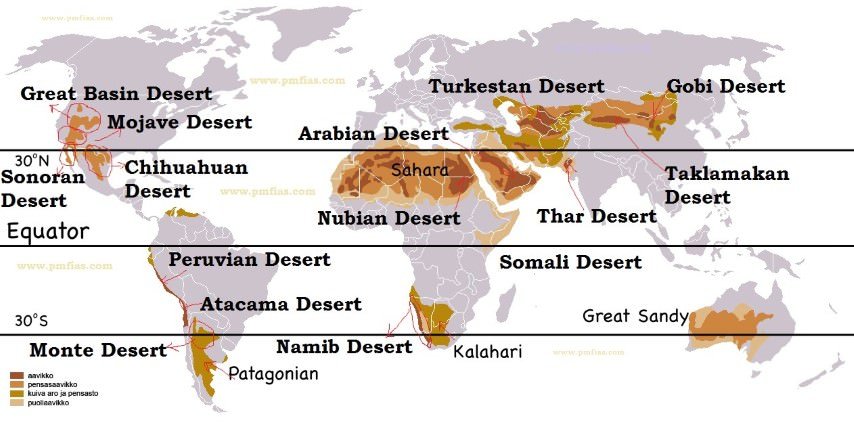
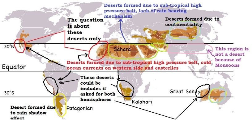
The subsiding air is warm and dry, therefore, most of the deserts are present along this belt, in both hemispheres.
A calm condition (anticyclonic) with feeble winds is created in this high pressure belt.
The descending air currents feed the winds blowing towards adjoining low pressure belts.
This belt is frequently invaded by tropical and extra-tropical disturbances.
Horse Latitudes
The corresponding latitudes of sub-tropical high pressure belt are called horse latitudes.
In early days, the sailing vessels with cargo of horses found it difficult to sail under calm conditions of this high pressure belt.
They used to throw horses into the sea when fodder ran out. Hence the name horse latitudes.
Question mains 2013
Major hot deserts in northern hemisphere are located between 20-30 degree north and on the western side of the continents. Why?
Why between 20 – 30 degree?
Answer: The subsiding air is warm and dry, therefore, most of the deserts are present along this belt, in both hemispheres.
Why on western side of the continents?
We will get answer for this while studying ocean currents.
Sub-Polar Low Pressure Belt
Located between 45°N and S latitudes and the Arctic and the Antarctic circles (66.5° N and S latitudes).
Owning to low temperatures in these latitudes the sub polar low pressure belts are not very well pronounced year long.
On long-term mean climatic maps, the sub polar low-pressure belts of the northern hemisphere are grouped into two centers of atmospheric activity: the Iceland low and the Aleutian depression (Aleutian low).
Such belts in the southern hemisphere surround the periphery of Antarctica and are not as well differentiated.
Formation
These are dynamically produced due to
Coriolis Force produced by rotation of the earth on its axis, and.
Ascent of air as a result of convergence of westerlies and polar easterlies (we will more about these in next topic – wind systems).
Sub polar low-pressure belts are mainly encountered above
Seasonal behavior
During winter, because of a high contrast between land and sea, this belt is broken into two distinct low centers – one in the vicinity of the Aleutian Islands and the other between Iceland and Greenland.
During summer, a lesser contrast results in a more developed and regular belt.
Climate
The area of contrast between cold and warm air masses produces polar jet streams which encircles the earth at 60 degrees latitudes and is focused in these low pressure areas.
Due to a great contrast between the temperatures of the winds from sub-tropical and polar source regions, extra tropical cyclonic storms or lows’ (temperate cyclones or frontal cyclones) are produced in this region.
Polar High Pressure Belt
The polar highs are small in area and extend around the poles.
They lie around poles between 80 – 90° N and S latitudes.
Formation
The air from sub-polar low pressure belts after saturation becomes dry. This dry air becomes cold while moving towards poles through upper troposphere.
The cold air (heavy) on reaching poles subsides creating a high pressure belt at the surface of earth.
Climate
The lowest temperatures are found over the poles.
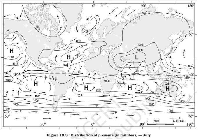
Pressure belts in July
In the northern hemisphere, during summer, with the apparent northward shift of the sun, the thermal equator (belt of highest temperature) is located north of the geographical equator.
The pressure belts shift slightly north of their annual average locations.
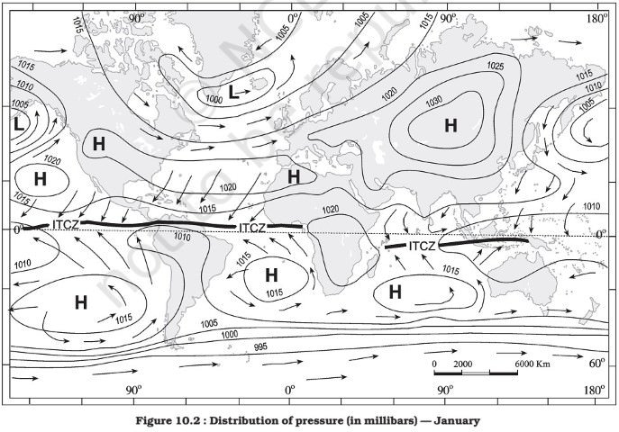
Pressure belts in January
During winter, these conditions are completely reversed and the pressure belts shift south of their annual mean locations. Opposite conditions prevail in the southern hemisphere. The amount of shift is, however, less in the southern hemisphere due to predominance of water.
Similarly, distribution of continents and oceans have a marked influence over the distribution of pressure. In winter, the continents are cooler than the oceans and tend to develop high pressure centres, whereas in summer, they are relatively warmer and develop low pressure. It is just the reverse with the oceans.
Factors Controlling Pressure Systems
There are two main causes, thermal and dynamic, for the pressure differences resulting in high and low pressure systems.
Thermal Factors
When air is heated, it expands and, hence, its density decreases. This naturally leads to low pressure. On the contrary, cooling results in contraction. This increases the density and thus leads to high pressure.
Formation of equatorial low and polar highs are examples of thermal lows and thermal highs, respectively.
Dynamic Factors
Apart from variations of temperature, the formation of pressure belts may be explained by dynamic controls arising out of pressure gradient forces and rotation of the earth (Coriolis force).
Example
After saturation (complete loss of mosture) at the ITCZ, the air moving away from equatorial low pressure belt in the upper troposphere becomes dry and cold. This dry and cold wind subsides at 30°N and S.
So the high pressure along this belt is due to subsidence of air coming from the equatorial region which descends after becoming heavy.
The rate of deflection increases with the distance from the equator (Coriolis force). As a result, by the time the poleward directed winds reach 25° latitude, they are deflected into a nearly west-to-east flow. It produces a blocking effect and the air piles up. This causes a general subsidence in the areas between the tropics and 35°N and S, and they develop into high pressure belts.
The location of pressure belts is further affected by differences in net radiation resulting from apparent movement of the sun and from variations in heating of land and water surfaces.
Thus formation of sub-tropical high and sub-polar low pressure belts are due to dynamic factors like pressure gradient forces, apparent movement of sun and rotation of the earth (Coriolis force)
Very nice , i am secretly following this page since long , just one question > if i purchase the geography set , will it also includes the links of video mapped many times with topics
What do you mean by “will it also includes the links of video mapped many times with topics”?
You will get all that you see on the website.
okay that is what I asked , thanks !!
Why the wind from equatorial low move towards polar high?? Usually wind flows from high pressure to low pressure
when the warm currents rise in low pressure zone they get condensed as they move above and accumulate, causing rainfall. after the saturation(losing moisture) now their pressure is also increased and as they become heavy they subsides in 30-35 degree N,S and form Sub Tropical High pressure zones
The hot air near the equator rises up and cools down when reaches a higher altitude. This cool air sinks down but due to the Coriolis effect, it turns to its right which will the towards the north in the northern hemisphere and towards the south in the southern hemisphere.
Where the subpolar low pressure belt is developed more regularly, is it southern hemisphere or northern hemisphere?
It is developed more regularly in the Southern Hemisphere due to over dominance of the oceans
A rising pressure indicates fine, settled weather, while a falling pressure indicates unstable and cloudy weather. Why is it so?? Can you please explain?
The subsiding air at STHP is warm and dry. Is it warm and dry or cold and dry? At one place, you have mentioned cold and dry and then in the next point, it is written warm and dry. Please explain?
Sir,a little bit information required that does your notes on the page which I’m reading is a clone of that theme (information)u mentioned in your vedio lectures ? Bcz my ears aren’t works normally.(hearing disability).
Sir,a little bit information required that does your notes on the page which I’m reading is a clone of that theme (information)u mentioned in your vedio lectures ? Bcz my ears aren’t works normally.(hearing disability).so students like me only depend on E- books.are they (written notes) sufficient.
Yes, they are clones. But the PDFs are better clones https://www.pmfias.com/. I recommend the PDFs (2019) over the web content (2016).
Sir can you please make video lectures of Indian geography too. They would be really helpful for us
Throughout the article, it is written that saturation is a complete loss of moisture, which is incorrect as saturation, in this context, means the state of containing moisture to the point that more moisture cannot be acquired or carried in the air. The correct term should be desaturation which is the loss of moisture. I request you to kindly rectify it.
Sir in a point u are saying that the cold and dry air subsides and in another point u are saying the subsiding air are warm and dry . Can u clear it?
Absolutely , fantastic work! May u rise and shine, you are helping students, god will help you definitely.
As temperature is inversely to height,I.e at lower troposhere temp.is high as cold and dry air sink its moisture will get evaporated and becomes dry. And then again on reaching group high pressure created and shows divergent properties
Mcq on earth pressure belt for upse