
Indian Islands: Andaman & Nicobar Islands, Lakshadweep Islands & New Moore Island
Indian Islands
- The major islands groups of India are Andaman and Nicobar Archipelago (A chain of islands similar in origin) in Bay of Bengal and Lakshadweep islands in Arabian Sea.
- Andaman and Nicobar Islands were formed due to collision between Indian Plate and Burma Minor Plate [part of Eurasian Plate][Similar to formation of Himalayas].
- Andaman and Nicobar Islands are southward extension of Arakan Yoma range [Myanmar][Arakan Yoma in itself is an extension of Purvanchal Hills].
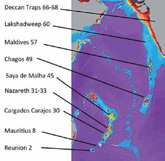
- Lakshadweep Islands are coral islands. These islands are a part Reunion Hotspot volcanism. [Both these concepts are explained in previous posts]
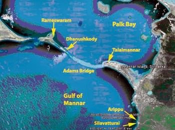
- Other than these two groups there are islands in Indo-Gangetic Delta [they are more a part of delta than islands] and between India and Sri Lanka [Remnants of Adams Bridge or Rama’s Bridge or Rama Setu; formed due to submergence].
Andaman and Nicobar Islands
- This archipelago is composed of 265 big and small islands [203 Andaman islands + 62 Nicobar Islands][Numbers are just for understanding. You need not remember trivial facts].
- The Andaman and Nicobar islands extend from 6° 45′ N to 13° 45′ N and from 92° 10′ E to 94° 15′ E for a distance
 of about 590 km.
 - The Andaman islands are divided into three main islands i.e. North, Middle and South.
- Duncan passage separates Little Andaman from South Andaman.
- The Great Andaman group of islands in the north is separated by the Ten Degree Channel from the Nicobar group in the south [Prelims 2014].
- Port Blair, the capital of Andaman Nicobar Islands lies in the South Andaman.
- Among the Nicobar islands, the Great Nicobar is the largest. It is the southernmost island and is very close to Sumatra island of Indonesia. The Car Nicobar is the northernmost.
- Most of these islands are made of tertiary sandstone, limestone and shale resting on basic and ultrabasic volcanoes [Similar to Himalayas].
- THE BARREN AND NARCONDAM ISLANDS, north of Port Blair, are volcanic islands [these are the only active volcanoes in India][There are no active volcanoes in main land India].
- Some of the islands are fringed with coral reefs. Many of them are covered with thick forests. Most of the islands are mountainous.
- Saddle peak (737 m) in North Andaman is the highest peak.
 of about 590 km.
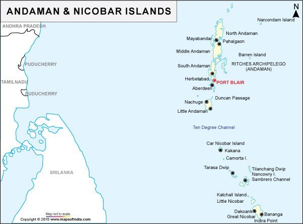
Lakshadweep Islands
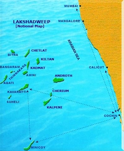
- In the Arabian Sea, there are three types of islands.
- Amindivi Islands (consisting of six main islands of Amini, Keltan, Chetlat, Kadmat, Bitra and Perumul Par). [don’t have to remember all these names]
- Laccadive Islands (consisting of five major islands of Androth, Kalpeni, Kavaratti, Pitti and Suheli Par) and
- Minicoy Island.
- At present these islands are collectively known as Lakshadweep.
- The Lakshadweep Islands are a group of 25 small islands.
- They are widely scattered about 200-500 km south-west of the Kerala coast.
- Amendivi Islands are the northern most while the Minicoy island is the southernmost.
- All are tiny islands of coral origin {Atoll} and are
- surrounded by fringing reefs.
- The largest and the most advanced is
 the Minicoy island with an area of 4.53 sq km.
 - Most of the islands have low elevation and do not rise more than five metre above sea level (Extremely Vulnerable to sea level change).
- Their topography is flat and relief features such as hills, streams, valleys, etc. are absent.
 the Minicoy island with an area of 4.53 sq km.
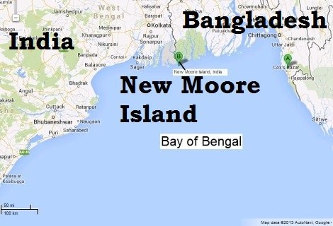
New Moore Island
- It is a small uninhabited offshore sandbar landform {Marine Landforms} in the Bay of Bengal, off the coast of the Ganges-Brahmaputra Delta region.
- It emerged in the Bay of Bengal in the aftermath of the Bhola cyclone in 1970. It keeps on emerging and disappearing.
- Although the island was uninhabited and there were no permanent settlements or stations located on it, both India and Bangladesh claimed sovereignty over it because of speculation over the existence of oil and natural gas in the region.
- The issue of sovereignty was also a part of the larger dispute over the Radcliffe Award methodology of settling the maritim
e boundary between the two nations.
Primary References: NCERT Geography, Indian Geography by Kullar [Amazon and Flipkart]


largest island of lakshadweep is Andrott…according to wikipidia please review it
Adams Bridge : called as RAMA SETU…don’t you write clearly..or you are a ANTI-HINDU element from SO called SECULAR GANG…
It is possible that he has not have knowledge about this fact that Adams bridge is also called rama setu but that doesn’t mean that it is anti hindu,,,,, I cannot believe that in India people of you type are still there in this era,,,,,
It is possible that he/she does not have knowledge about this fact that Adams bridge is also called rama setu but that doesn’t mean that it is anti hindu,,,,, I cannot believe that in India people of you type are still there in this era,,,,,
Amindivi Islands consisting of six main islands of Ami ni,keltan ,chetlat ,kadmat,bitra and perumul par. you have given this information .But you have seen others name like chetlat ,kiltan ,agati on your map .These names are not matching with your previous islands name .plz tell me which is correct .I am confusing to see this .
Lakshadweep island is group of 36 islands not 25 islands