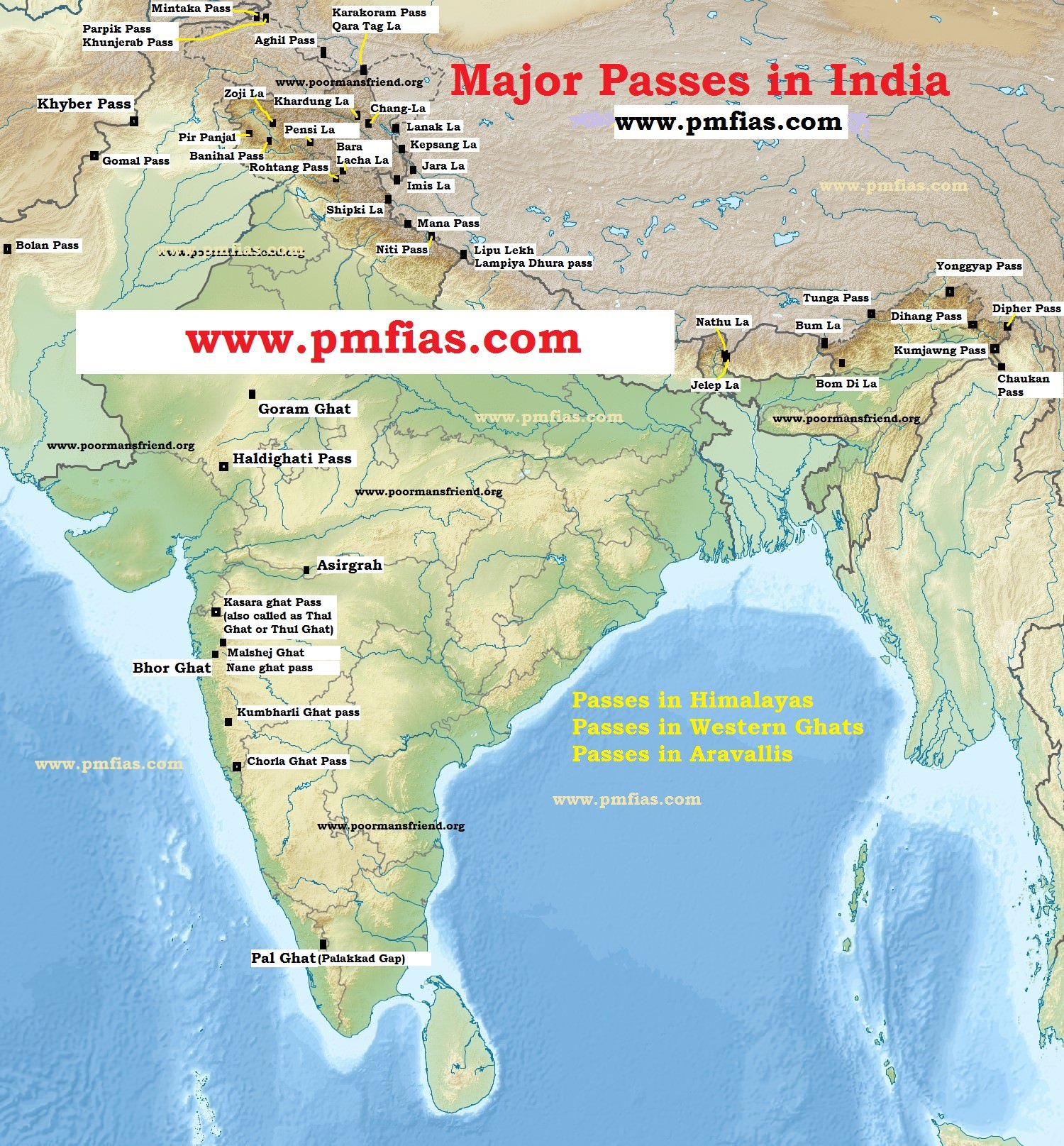
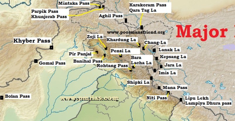
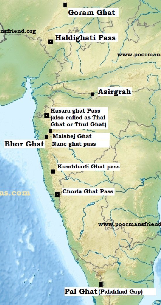
Passes of the Western Himalayas
|
Jammu and Kashmir
|
NAME
|
SIGNIFICANCE (CONNECTS)
|
COMMENTS
|
Mintaka Pass
|
Kashmir and China |
- Trijunction of India-China and Afghanistan border
|
Parpik Pass
|
Kashmir and China |
- East of Mintaka pass on the Indo-China border
|
Khunjerab Pass
|
Kashmir and China |
|
Aghil Pass
|
Ladakh region of India with the Xinjiang (Sinkiang) Province of China |
- 5000 m above sea level.
- north of K2 Peak (the highest peak in India and the second highest peak in the world)
|
Banihal Pass
|
Jammu and Srinigar |
- 2832 m
- across the Pir-Panjal Range
- remains snow covered during winter season
|
- The road from Jammu to Srinagar transversed Banihal Pass until 1956 when Jawahar Tunnel was constructed under the pass. The road now passes through the tunnel and the Banihal Pass is no longer used for road transport.
- Another 11 km long tunnel provides railway link between Banihal and Kazigund. It was thrown open to railway transport in July, 2013
|
Chang-La
|
Ladakh with Tibet |
- altitude of 5360 m
- This has a temple dedicated to Chang-La Baba after whom the temple has been named
|
Khardung La
|
near Leh in the Ladakh range |
The world’s highest motorable road passes through this pass
- remains closed in winter due to heavy snowfall
|
Lanak La
|
India and China (Akasai-Chin area of Jammu and Kashmir) |
- this pass provides passage between Ladak and Lhasa. A road to connect Xinjiang Province with Tibet has been constructed by the Chinese
|
Pir-Panjal pass
|
across the Pir Panjal range |
provides the shortest and the easiest metal road between Jammu and Kashmir Valley. But this route had to be closed down as a result of partition of the subcontinent |
Qara Tag La
|
Indo-China borer across the Karakoram Range |
- located at an elevation of over six thousand metres
|
Imis La
|
Ladakh region of India and Tibet in China |
|
Pensi La
|
vital link between the Kashmir Valley and Kargil |
- remains closed to traffic from November to mid-May due to heavy snowfall
|
Zoji La
|
important road link between Srinagar on one side and Kargil and Leh on the other side |
- The road passing through this pass has been designated at the National Highway (NH-1D)
- Border Road Organisation (BRO) is responsible for maintaining the road and cleaning it off snow during winter. In spite of all these efforts, the road through this pass remains closed from December to mid-May
|
Himachal Pradesh
|
Bara Lacha La
|
Himachal Pradesh and Jammu and Kashmir |
- Elevation: 4,890 m
- National highway connecting Mandi in Himachal Pradesh with Leh in Jammu and Kashmir passes through this pass. Being situated at high altitude, it remains snow covered in winter and is not used as a transport route.
|
Debsa Pass
|
link between Kullu and Spiti districts |
- elevation of 5270 m above sea level
- It offers a much easier and shorter alternative route to traditional Pin-Parbati Pass route between Kullu and Spiti
|
Rohtang Pass
|
road link between Kullu, Lahul and Spiti Valleys |
- Elevation: 3979 m
- Border Road Organisation (BRO) is responsible for constructing and maintaining roads in this area. Rohtang pass is a great tourist attraction and traffic jams are very common because this route is widely used by military, public and private vehicles.
|
Shipki La
|
Himachal Pradesh and Tibet |
- Elevation: 6000 m
- Remains closed in winter season (Nov – Apr)
|
Uttarakhand
|
Lipu Lekh
|
trijunction of Uttarakhand (India), Tibet (China) and Nepal borders |
This pass is used by pilgrims to Kailash-Mansarowar. |
Mana Pass
|
Uttarakhand with Tibet |
- elevation of 5610
- Situated a little north of the holy place of Badhrinath
- Remains closed in winter season (Nov – Apr)
|
Mangsha Dhura
|
Uttarakhand with Tibet |
It is used by pilgrims going to Kailash-Mansarowar |
Niti Pass
|
Uttarakhand with Tibet |
- Remains closed in winter season (Nov – Apr)
|
Muling La
|
Uttarakhand and Tibet |
- situated in the north of Gangotri
- at an elevation of 5669 m in the Great Himalayas
|
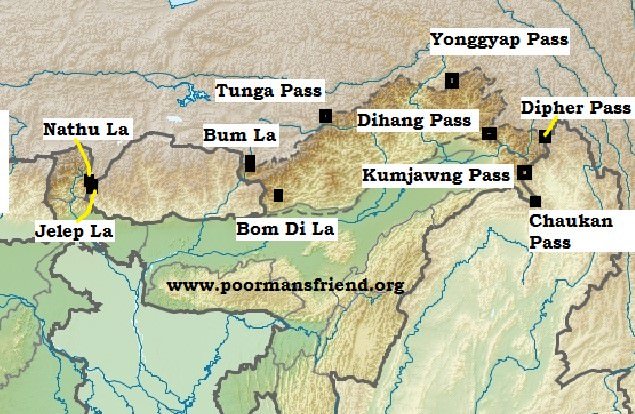
Passes of the Eastern Himalayas
|
Sikkim
|
Nathu La
|
Sikkim with Tibet |
- altitude of 4310 m
- it forms part of an offshoot of the ancient Silk Route
- an important trade route between India and China
- It was closed after the Chinese aggression on India in 1962 but was reopened in 2006 as the governments of the two countries decided to enhance their trade through land routes
|
Jelep La
|
Sikkim-Bhutan border |
- altitude of 4538 m
- passes through Chumbi Valley
- important link between Sikkim and Lhasa
|
Arunachal Pradesh
|
Bom Di La
|
Arunachal Pradesh with Bhutan |
- altitude of 4331 m
- Situated at an altitude of 4331 m near the western boundary of Arunachal Pradesh in the Greater Himalayas, this pass connects Arunachal Pradesh with Lhasa
|
Dihang Pass
|
Arunachal Pradesh and Myanmar. |
- elevation of more than 4000 m it provides passage
|
Yonggyap Pass
|
Arunachal Pradesh with Tibet |
|
Dipher Pass
|
trijunction of India, China and Myanmar |
- easy access between Arunachal Pradesh and Mandalay in Myanmar. It is an important land trade route between India and Myanmar and remains open throughout the year.
|
Kumjawng Pass
|
Arunachal Pradesh with Myanmar |
|
Hpungan Pass
|
Arunachal Pradesh with Myanmar |
|
Chankan Pass
|
Arunachal Pradesh with Myanmar |
|


This is a great initiative . If you link yourself with telegram and making its settings such that only you can post in the group whereas others can only view and no comment as many group owners have done it,it would be great.This move will be a bonus for many who through the telegram can view it as itll be updated on a daily basis.
Facebook page is more convenient.
Well said dude
Is the Dipher pass also call Talu Pass??
Some sources mention that on the Bhutanese side it is called as Talu Pass.
Arunachal pradesh having Bum La pass in Tawang ..
Can I get a pdf of this page? I have already subscribed to Geography GS notes but the passes section is not present in the downloads
It is given in Indian Geography PDF
Mast app
hmm
Informative bhai