Himalayan River Systems
- The Indus, the Ganga and the Brahmaputra comprise the Himalayan river systems.
- The Himalayan Rivers existed even before the formation of Himalayas i.e. before the collision of Indian Plate with the Eurasian plate. {Antecedent Drainage}
- They were flowing into the Tethys Sea. These rivers had their source in the now Tibetan region.
- The deep gorges of the Indus, the Satluj, the Brahmaputra etc. clearly indicate that these rivers are older than the Himalayas.
- They continued to flow throughout the building phase of the Himalayas; their banks rising steeply while the beds went lower and lower due to vertical erosion (Vertical down cutting was significant and was occurring at a rate faster than the rising of Himalayas), thus cutting deep gorges.
- Thus, many of the Himalayan Rivers are typical examples of antecedent drainage.
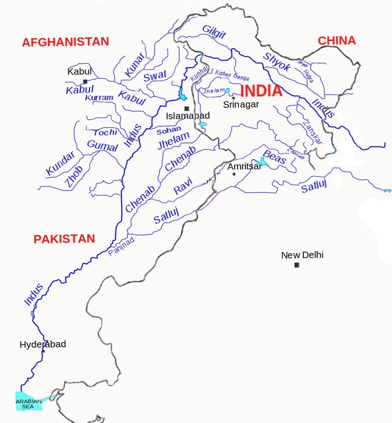
Indus River System
| Sindhu |
Sanskrit |
| Sinthos |
Greek |
| Sindus |
Latin |
Major Rivers of Indus River System
|
Source
|
Length
|
| Indus |
Glaciers of Kailas Range (Close to Manasarovar Lake) |
2880 km total.
710 km in India |
| Jhelum |
Verinag |
720 km |
| Chenab |
Bara Lacha Pass |
1180 km |
| Ravi |
Near Rohtang Pass |
725 km |
| Beas |
Near Rohtang Pass |
460 km |
| Satluj |
Manasarovar-Rakas Lakes |
1450 km total
1050 km in India |
Indus River
- India got her name from Indus.
- ‘The Indus Valley Civilization’ was born around this river.
- It flows in north-west direction from its source (Glaciers of Kailas Range – Kailash range in Tibet near Lake Manasarovar) till the Nanga Parbhat Range.
- It’s length is about 2,900 km. Its total drainage area is about 1,165,000 square km [more than half of it lies in semiarid plains of Pakistan]. It is joined by Dhar River near Indo-China border.
- After entering J&K it flows between the Ladakh and the Zaskar Ranges. It flows through the regions of Ladakh, Baltistan and Gilgit.
- The gradient of the river in J&K is very gentle (about 30 cm per km).
- Average elevation at which the Indus flows through JK is about 4000 m above sea level.
- It is joined by the Zaskar River at Leh (these kind of points are important for prelims).
- Near Skardu, it is joined by the Shyok at an elevation of about 2,700 m.
- The Gilgit, Gartang, Dras, Shiger, Hunza are the other Himalayan tributaries of the Indus.
- It crosses the Himalayas (ends its mountainous journey) through a 5181 m deep gorge near Attock, lying north of the Nanga Parbat. It takes a sharp southerly bend here (syntaxial bend).
- Kabul river from Afghanistan joins Indus near Attock. Thereafter it flows through the Potwar plateau and crosses the Salt Range (South Eastern edge of Potwar Plateau).
- Some of the important tributaries below Attock include the Kurram, Toch and the Zhob-Gomal.
- Just above Mithankot, the Indus receives from Panjnad (Panchnad), the accumulated waters of the five eastern tributaries—the Jhelum, the Chenab, the Ravi, the Beas and the Satluj.
- The river empties into the Arabian Sea south of Karachi after forming a huge delta.
Major Tributaries of Indus River
Jhelum River
- The Jhelum has its source in a spring at Verinag in the south-eastern part of the Kashmir Valley.
- It flows northwards into Wular Lake (north-western part of Kashmir Valley). From Wular Lake, it changes its course southwards. At Baramulla the river enters a gorge in the hills.
- The river forms steep-sided narrow gorge through Pir Panjal Range below Baramula.
- At Muzaffarabad, the river takes a sharp hairpin bend southward.
- Thereafter, it forms the India-Pakistan boundary for 170 km and emerges at the Potwar Plateau near Mirpur.
- After flowing through the spurs of the Salt Range it debouches (emerge from a confined space into a wide, open area) on the plains near the city of Jhelum.
- It joins the Chenab at Trimmu.
- The river is navigable for about 160 km out of a total length of 724 km.
Chenab River
- The Chenab originates from near the Bara Lacha Pass in the Lahul-Spiti part of the Zaskar Range.
- Two small streams on opposite sides of the pass, namely Chandra and Bhaga, form its headwaters at an altitude of 4,900 m.
- The united stream Chandrabhaga flows in the north-west direction through the Pangi valley, parallel to the Pir Panjal range.
- Near Kistwar, it cuts a deep gorge.
- It enters the plain area near Akhnur in Jammu and Kashmir.
- From here it through the plains of Pakistani Punjab to reach Panchnad where it joins the Satluj after receiving the waters of Jhelum and Ravi rivers.
Ravi River
- The Ravi has its source in Kullu hills near the Rohtang Pass in Himachal Pradesh.
- It drains the area between the Pir Panjal and the Dhaola Dhar ranges.
- After crossing Chamba, it takes a south-westerly turn and cuts a deep gorge in the Dhaola Dhar range.
- It enters Punjab Plains near Madhopur and later enters Pakistan below Amritsar.
- It debouches into the Chenab a little above Rangpur in Pakistani Punjab.
Beas River
- The Beas originates near the Rohtang Pass, at a height of 4,062 m above sea level, on the southern end of the Pir Panjal Range, close to the source of the Ravi.
- It crosses the Dhaola Dhar range and it takes a south-westerly direction and meets the Satluj river at Harike in Punjab.
- It is a comparatively small river which is only 460 km long but lies entirely within the Indian territory.
Satluj River
- The Satluj rises from the Manasarovar-Rakas Lakes in western Tibet at a height of 4,570 m within 80 km of the source of the Indus.
- Like the Indus, it takes a north-westerly course upto the Shipki La on the Tibet-Himachal Pradesh boundary.
- It cuts deep gorges where it pierces the Great Himalaya and the other Himalayan ranges.
- Before entering the Punjab plain, it cuts a gorge in Naina Devi Dhar, where the famous Bhakra dam has been constructed.
- After entering the plain at Rupnagar (Ropar), it turns westwards and is joined by the Beas at Harike.
- From near Ferozepur to Fazilka it forms the boundary between India and Pakistan for nearly 120 km.
- During its onward journey it receives the collective drainage of the Ravi, Chenab and Jhelum rivers. It joins the Indus a few kilometres above Mithankot.
- Out of its total length of 1,450 km, it flows for 1,050 km in Indian territory.
Indus water treaty
- The waters of the Indus river system are shared by India and Pakistan according to the Indus Water Treaty signed between the two countries on 19th September, 1960.
- According to this treaty, India can utilize only 20 per cent of its total discharge of water.
Primary References: NCERT Geography, Govt Website, Indian Geography by Kullar [Amazon and Flipkart]


good information
It crosses the Himalayas (ends its mountainous journey) through a 5181 m deep gorge near Attock, lying north of the Nanga Parbat. It takes a sharp southerly bend here (syntaxial bend).
Sir some mistake here
Indus take sharp turn north of nanga parbat and reaches attock(a place in pakistan),it is not near nanga parbat
its a shame..!! map to sahi bana dete sir
Apologies, I will correct the map in the next revision.
still not corrected
Will be doing it in Jan 2019
you know PMFIAS, there is a law to punish those who intentionally depict wrong map of India. People have pointed out the mistake that you had committed, but instead of correcting it immediately, you have very conveniently said that you will do it in Jan 2019.
Please correct it asap or delete the wrong map. Otherwise, I will complain to the authorities.
That was not intentional. I just didn’t give it a good look while uploading. However, I have corrected it now. I am working on remedying every single map. Just give me some time. I will finish the corrections by Jan 2019.
Sir aap he btao . 2021 pre me Indus wale ka answer kya hoga… Chenab ya Sutlej?
Sir/Ma’am,
Indus never flows between Ladakh and Zanskar range. It always stays in between Karakoram and Ladakh Range. The map in NCERT Class XI : Physical Indian Geography shows it that way too. Please verify the diagrams.
Appreciate the work you do.
Thank You.
I stand corrected. The later diagrams in NCERT show the position properly.
In diagram it shows Karakoram and Ladakh range but read the text of the book it says Indus flows between Ladakh and Zaskar range.
J&K nikalke Ladak union territory ka correction kariye sr/mam.
It is not south of karachi it is east of karachi
When will the Indian geography book come???