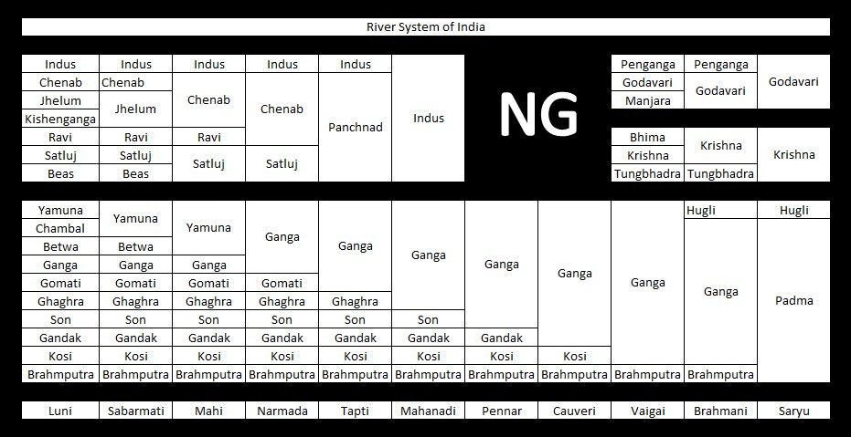
Ganga River System
River
|
Source
|
| Bhagirathi (Ganga) |
Gangotri glacier |
| Yamuna |
Yamnotri glacier on the Bandarpunch Peak |
| Chambal |
Janapao Hills in the Vindhya Range |
| Banas |
Aravali Range |
| Betwa |
Bhopal district |
| Ken |
Barner Range |
| Son |
Amarkantak Plateau |
| Damodar (‘Sorrow of Bengal’) |
Chotanagpur plateau |
| Ramganga River |
Garhwal district of Uttarakhand |
| Ghaghra River
|
Gurla Mandhata peak, south of Manasarovar in Tibet (river of the trans-Himalayan origin) |
| The Kali River (border between Nepal and Uttarakhand) |
Glaciers of trans-Himalayas |
| Gandak River |
Tibet-Nepal border |
| Burhi Gandak |
Sumesar hills near the India-Nepal border |
| Kosi (‘Sorrow of Bihar’) |
Tumar, Arun and Sun Kosi unite at Triveni north of the Mahabharata Range to form the Kosi. |
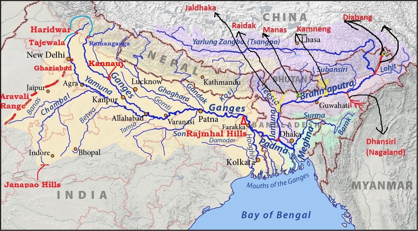
Ganga River
- The Ganga originates as Bhagirathi from the Gangotri glacier in Uttar Kashi District of Uttarakhand at an elevation of 7,010 m.
- Alaknanda River joins Bhagirathi at Devaprayag.
- From Devapryag the river is called as Ganga.
- The Ganges was ranked as the fifth most polluted river of the world in 2007.
- Pollution threatens many fish species and amphibian species and the endangered Ganges river dolphin (Blind Dolphin).
- The Ganga Action Plan, an environmental initiative to clean up the river, has been a major failure thus far, due to corruption, lack of technical expertise, poor environmental planning, and lack of support from religious authorities.
|
Major tributaries of Alaknanda
- East Trisul (joins Alaknanda at Karan Prayag)
- Pindar (rises from Nanda Devi)
- Mandakini or Kali Ganga (joins Alaknanda at Rudra Prayag)
- Dhauliganga
- Bishenganga.
[Kishenganga is the tributary of Jhelum] |
Major tributaries of Bhagirathi
|
- Ganga debouches [emerge from a confined space into a wide, open area] from the hills into plain area at
- It is joined by the Yamuna at Allahabad.
- Near Rajmahal Hills it turns to the south-east.
- At Farraka, it bifurcates into Bhagirathi-Hugli in West Bengal and Padma-Meghna in Bangladesh (it ceases to be known as the Ganga after Farraka).
- Brahmaputra (or the Jamuna as it is known here) joins Padma-Meghna at
- The total length of the Ganga river from its source to its mouth (measured along the Hugli) is 2,525 km.
Ganga – Brahmaputra Delta
- Before entering the Bay of Bengal, the Ganga, along with the Brahmaputra, forms the largest delta of the world between the Bhagirathi/Hugli and the Padma/Meghna covering an area of 58,752 sq km.
- The coastline of delta is a highly indented area.
- The delta is made of a web of distributaries and islands and is covered by dense forests called the
- A major part of the delta is a low-lying swamp which is flooded by marine water during high tide.
Right Bank Tributaries of The Ganga
- Most of them except Yamuna originate in the peninsular region.
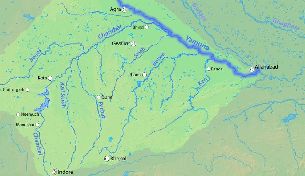
Yamuna River
- Largest and the most important tributary.
- It originates from the Yamnotri glacier on the Bandarpunch Peak in the Garhwal region in Uttarakhand at an elevation of about 6,000 meters.
- It cuts across the Nag Tibba, the Mussoorie and the Shiwalik ranges.
- It emerges out of the hilly area and enters plains near
- Its main affluent in the upper reaches is the Tons which also rises from the Bandarpunch glacier.
- It joins Yamuna below Kalsi before the latter leaves the hills.
- At this site, the water carried by the Tons is twice the water carried by the Yamuna.
Non – Peninsular Tributaries
1. Rishiganga
2. Uma
3. Hanuman Ganga and
4. Tons join it in the mountains.
5. Hindon joins at Ghaziabad in the plain area |
Peninsular Tributaries
Most of the Peninsular rivers flow into the Yamuna between Agra and Allahabad.
1. Chambal
2. Sind
3. Betwa
4. Ken. |
- It unites with the Ganga near Triveni Sangam, Allahabad.
- The total length of the Yamuna from its origin till Allahabad is 1,376 km.
- It creates the highly fertile alluvial, Yamuna-Ganges Doab region between itself and the Ganges in the Indo-Gangetic plain.
Chambal River
- The Chambal rises in the highlands of Janapao Hills (700 m) in the Vindhyan Range.
- It flows through the Malwa Plateau.
- It joins the Yamuna in Etawah district of Uttar Pradesh.
- The river flows much below its banks due to severe erosion because of poor rainfall and numerous deep ravines have been formed in the Chambal Valley, giving rise to badland topography. {Arid Landforms}
- The total length of the river is 1,050 km.
Dams on the Chambal
- The Gandhi Sagar dam is the first of the four dams built on the Chambal River, located on the Rajasthan-Madhya Pradesh border.
- The Rana Pratap Sagar dam is a dam located 52 km downstream of Gandhi Sagar dam on across the Chambal River in Chittorgarh district in Rajasthan.
- The Jawahar Sagar Dam is the third dam in the series of Chambal Valley Projects, located 29 km upstream of Kota city and 26 km downstream of Rana Pratap Sagar dam.
- The Kota Barrage is the fourth in the series of Chambal Valley Projects, located about 0.8 km upstream of Kota City in Rajasthan.
- Water released after power generation at Gandhi Sagar dam, Rana Pratap Sagar dam and Jawahar Sagar Dams, is diverted by Kota Barrage for irrigation in Rajasthan and in Madhya Pradesh through canals.
| Keoladeo National Park is supplied with water from Chambal river irrigation project. |
Banas River
- The Banas is a tributary of the Chambal.
- It originates in the southern part of the Aravali Range.
- It join the Chambal on Rajasthan – Madhya Pradesh border near Sawai Madhopur.
Sind River
- The Sind originates in Vidisha Plateau of Madhya Pradesh.
- It flows for a distance of 415 km before it joins the Yamuna.
Betwa River
- The Betwa rises in Bhopal district (Vindhyan Range) and joins the Yamuna near
- It has a total length of 590 km.
- The Dhasan is its important tributary.
Ken River
- The Ken river rising from the Barner Range of Madhya Pradesh joins the Yamuna near Chila.
Son River
- The Son River rises in the Amarkantak Plateau.
- Its source is close to the origin of the Narmada.
- It passes along the Kaimur Range.
- It joins the Ganga near Danapur in Patna district of Bihar.
- It flows for a distance of 784 km from its source.
- The important tributaries of the Son are the Johilla, the Gopat, the Rihand, the Kanhar and the North Koel. Almost all the tributaries join it on its right bank.
Damodar river
- The Damodar river rises in the hills of the Chotanagpur plateau and flows through a rift valley.
- Rich in mineral resources, the valley is home to large-scale mining and industrial activity.
- It has a number of tributaries and subtributaries, such as Barakar, Konar, Bokaro, Haharo, etc.
- The Barakar is the most important tributary of the Damodar.
- Several dams have been constructed in the valley, for the generation of hydroelectric power. The valley is called “the Ruhr of India”.
- The first dam was built across the Barakar River, a tributary of the Damodar river.
- It used to cause devastating floods as a result of which it earned the name ‘Sorrow of Bengal’. Now the river is tamed by constructing numerous dams.
- It joins the Hugli River 48 km below Kolkata.
- The total length of the river is 541 km.
Left Bank Tributaries of The Ganga River
- These rivers originate in the Himalayas.
- The major tributaries apart from the Yamuna, are the Ramganga, the Gomati, the Ghaghra, the Gandak, the Burhi Gandak, the Bagmati, and the Kosi.
Ramganga River
- The Ramganga river rises in the Garhwal district of Uttarakhand.
- It enters the Ganga Plain near Kalagarh.
- It joins the Ganga at
- The Khoh, the Gangan, the Aril, the Kosi, and the Deoha (Gorra) are important tributaries of Ramganga.
Ghaghra River
- Its source is near Gurla Mandhata peak, south of Manasarovar in Tibet (river of the trans-Himalayan origin).
- It is known as the Karnaili in Western Nepal.
- Its important tributaries are the Sarda, the Sarju (Ayodhya is located on its bank) and the Rapti.
- The Ghaghara joins the Ganga a few kilometres downstream of Chhapra in Bihar.
- After reaching the plain area, its stream gets divided into many branches of which, Koriyab and Garwa are important.
- The river bed is sandy and sudden bends start occurring in the stream.
- The river has a high flood frequency and has shifted its course several times.
Kali River
- Rises in the high glaciers of trans-Himalaya.
- It forms the boundary between Nepal and Kumaon.
- It is known as the Sarda after it reaches the plains near Tanakpur.
- It joins the
Gandak River
- Originates near the Tibet-Nepal border at a height of 7,620 m
- It receives a large number of tributaries in Nepal Himalaya.
- Its important tributaries are the Kali Gandak, the Mayangadi, the Bari and the Trishuli.
- It debouches into the plains at
- It flows into Ganga at Hajipur in Bihar.
Burhi Gandak
- Originates from the western slopes of Sumesar hills near the India-Nepal border.
- It joins the Ganga near Monghyr town.
Kosi River
- The Kosi river consists of seven streams namely Sut Kosi, Tamba Kosi, Talkha, Doodh Kosi, Botia Kosi, Arun and Tamber and is popularly known as
- These streams flow through eastern Nepal which is known as the Sapt Kaushik region.
- The sources of seven streams of the Kosi are located in snow covered areas which also receive heavy rainfall.
- Consequently, huge volume of water flows with tremendous speed.
- Seven streams mingle with each other to form three streams named the Tumar, Arun and Sun Kosi.
- They unite at Triveni north of the Mahabharata Range to form the Kosi.
- The river enters the Tarai of Nepal after cutting a narrow gorge in the Mahabharata Range.
- The joins the Ganga near
- Soon after debouching onto the plain the river becomes sluggish.
- Large scale deposition of eroded material takes place in the plain region.
- The river channel is braided and it shifts its course frequently. This has resulted in frequent devastating floods and has converted large tracts of cultivable land into waste land in Bihar. Thus the river is often termed as the ‘Sorrow of Bihar’.
- In order to tame this river, a barrage was constructed in 1965 near Hanuman Nagar in Nepal.
- Embankments for flood control have been constructed as a joint venture of India and Nepal.
Brahmaputra River System
Region
|
Name
|
| Tibet |
Tsangpo (meaning ‘The Purifier’) |
| China |
Yarlung Zangbo Jiangin |
| Assam Valley |
Dihang or Siong, South of Sadiya: Brahmaputra |
| Bangladesh |
Jamuna River |
| Padma River: Combined Waters of Ganga and Brahmaputra |
| Meghana: From the confluence of Padma and Meghna [View image above] |
- The Brahmaputra (meaning the son of Brahma).
- It is 2,900 km in length.
- Source: Chemayungdung glacier (Kailas Range) at an elevation of about 5,150 m. It’s source is very close to the sources of Indus and Satluj.
- Mariam La separates the source of the Brahmaputra from the Manasarovar Lake.
- Brahmaputra flows eastwards in Southern Tibet for about 1,800 km.
- In Tibet it passes through the depression formed by the Indus-Tsangpo Structure Zone between the Great Himalayas in the south and the Kailas Range in the north.
- Inspite of the exceptionally high altitude, the Tsangpo has a gentle slope. The river is sluggish and has a wide navigable channel for about 640 km.
- It receives a large number of tributaries in Tibet. The first major tributary is the Raga Tsangpo meeting the Tsangpo near Lhatse Dzong.
- The river Ngangchu flows through the trade centre of Gyantse in the south and joins the main river.
- Towards the end of its journey in Tibet, its course abruptly takes a south ward turn around Namcha Barwa (7,756 m)(Syntaxial Bend).
- Here it cuts across the eastern Himalaya through the Dihang or Siang Gorge and emerges from the mountains near Sadiya in the Assam Valley.
- Here it first flows under the name of Siong and then as the Dihang.
- In the north-eastern parts of Assam Valley, it is joined by two important tributaries viz, the Dibang (or Sikang) from the north and Lohit from the south.
- From Sadiya (Assam Valley) onwards, this mighty river is known as the
- The main streams merging with the Brahmaputra from the north are, Subansiri, Kameng, Dhansiri (north), Raidak, Tista etc..
- The Tista was a tributary of the Ganga prior to the floods of 1787 after which it diverted its course eastwards to join the Brahmaputra.
- The Brahmaputra has a braided channel (flow into shallow interconnected channels divided by deposited earth) for most of its passage through Assam where channels keep shifting. It carries a lot of silt and there is excessive meandering.
- The river is nearly 16 km wide at Dibrugarh and forms many islands, the most important of which is MAJULI. It is 90 km long and measures 20 km at its widest.
- With rainfall concentrated during the monsoon months only the river has to carry enormous quantities of water and silt which results in disastrous floods. The Brahmaputra is thus truly a River of Sorrow.
- The river is navigable for a distance of 1,384 km upto Dibrugarh from its mouth and serves as an excellent inland water transport route.
- Brahmaputra bends southwards and enters Bangladesh near Dhubri.
- It flows for a distance of 270 km in the name of Jamuna river and joins the Ganga at
- The united stream of the Jamuna and the Ganga flows further in the name of
- About 105 km further downstream, the Padma is joined on the left bank by the Meghna, originating in the mountainous region of Assam.
- From the confluence of Padma and Meghna, the combined river is known as the Meghna which makes a very broad estuary before pouring into the Bay of Bengal.
Primary References: NCERT Geography, Govt Website, Indian Geography by Kullar [Amazon and Flipkart]


thanks
It would be better if you could mention the sides from which tributaries merge in main river.
Also, Please correct north and south tributaries of Brahmaputra. (Dibang, Lohit and Dhansiri are south bank tributaries)
Helpfull pdf
The Betwa rises in Bhopal district (Vindhyan Range) and joins the Yamuna near
near what sir?
It is very helpful and easy to understand. This post is covered all major rivers of India. Pics of the Ganga river is awesome, as well as showing of the table of tributaries style is really amazing.
Thanks for sharing this informative post.
some key words are missing like Ganga rebounces at….. what?. Many such places are there. otherwise it is very help full.
..
its very helpful to understand the river range in India but we dont get the full knowledge abut the Indian river means in sequal wise.
Kindly correct elevation of gangotri glacier
Hi, please fill in the words that are missing. It is mostly the keywords.
Informative but many keywords are missing.
Please fill them, it will become more informative and one will not need to search more content for the sake of finding these missing words and it will eventually save the time.
Thank you.