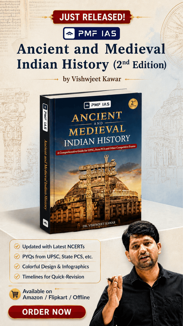
Statement 2 is correct
- Textile and Textile articles” constitute an important item of trade between India and Bangladesh.
- Textiles contributed 31.3% of Indian exports to Bangladesh in 2016-17. The other prominent products of export were engineering products (around 25% of exports), Chemical products (9% of exports) and vegetable products such as fresh vegetables (8% of exports).
Statement 3 is incorrect
Answer: (b) 2 only; Difficulty Level: Hard
In which one of the following groups are all the four countries members of G20?
- Argentina, Mexico, South Africa and Turkey
- Australia, Canada, Malaysia and New Zealand
- Brazil, Iran, Saudi Arabia and Vietnam
- Indonesia, Japan, Singapore and South Korea
Explanation
Option (a) is correct
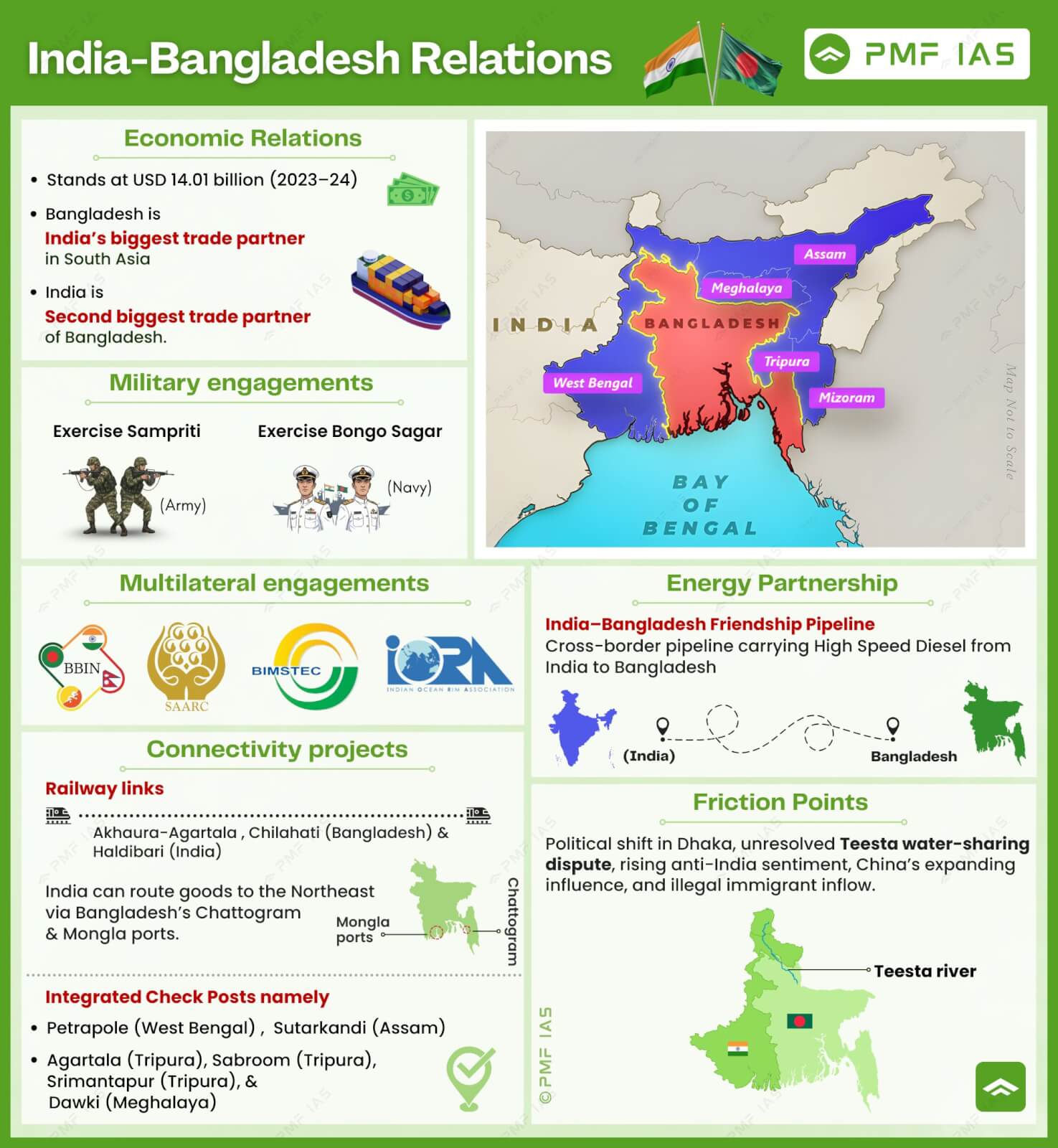
- The Group of Twenty (G20) is a forum for international economic cooperation consisting of 19 countries, the EU, and the African Union.
Answer: (a) Argentina, Mexico, South Africa and Turkey; Difficulty Level: Medium
Under the Kisan Credit Card Scheme, short-term credit support is given to farmers for which of the following purposes?
- Working capital for maintenance of farm assets
- Purchase of combine harvesters, tractors and mini trucks
- Consumption requirements of farm households
- Post-harvest expense
- Construction of family house and setting up of village cold storage facility
Select the correct answer using the code given below:
- 1, 2 and 5 only
- 1, 3 and 4 only
- 2, 3, 4 and 5 only
- 1, 2, 3, 4 and 5
Explanation
Option (b) is correct
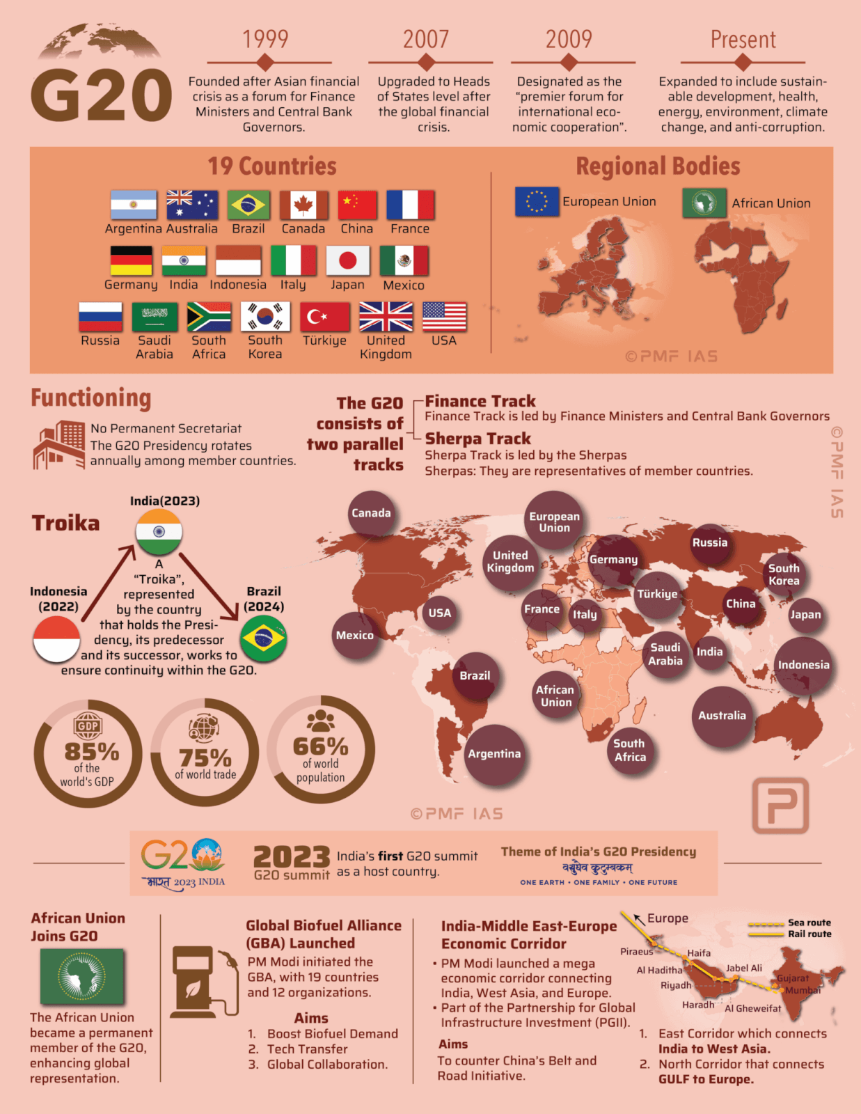
- The scheme was introduced in 1998 to provide farmers with adequate and timely credit support. It was extended for Allied and non-farm activities in 2004. Electronic Kisan Credit Cards have been issued on the Working Group report under T. M. Bhasin. The age group of 18-75 years is eligible for KCC. Senior citizens must have a legal heir as a co-borrower.
- Objectives: To meet the short-term credit requirements for the cultivation of crops.
- Post-harvest expenses.
- Produce marketing loan.
- Consumption requirements of farmer households.
- Working capital for maintenance of farm assets and activities allied to agriculture.
- Investment credit requirement for agriculture and allied activities.
Answer: (b) 1, 3 and 4; Difficulty Level: Hard
Consider the following statements:
- The weightage of food in Consumer Price Index (CPI) is higher than that in Wholesale Price Index (WPI).
- The WPI does not capture changes in the prices of services, which CPI does.
- The Reserve Bank of India has now adopted WPI as its key measure of inflation and to decide on changing the key policy rates.
Which of the statements given above is/are correct?
- 1 and 2 only
- 2 only
- 3 only
- 1, 2 and 3
Explanation
Statement 1 is correct
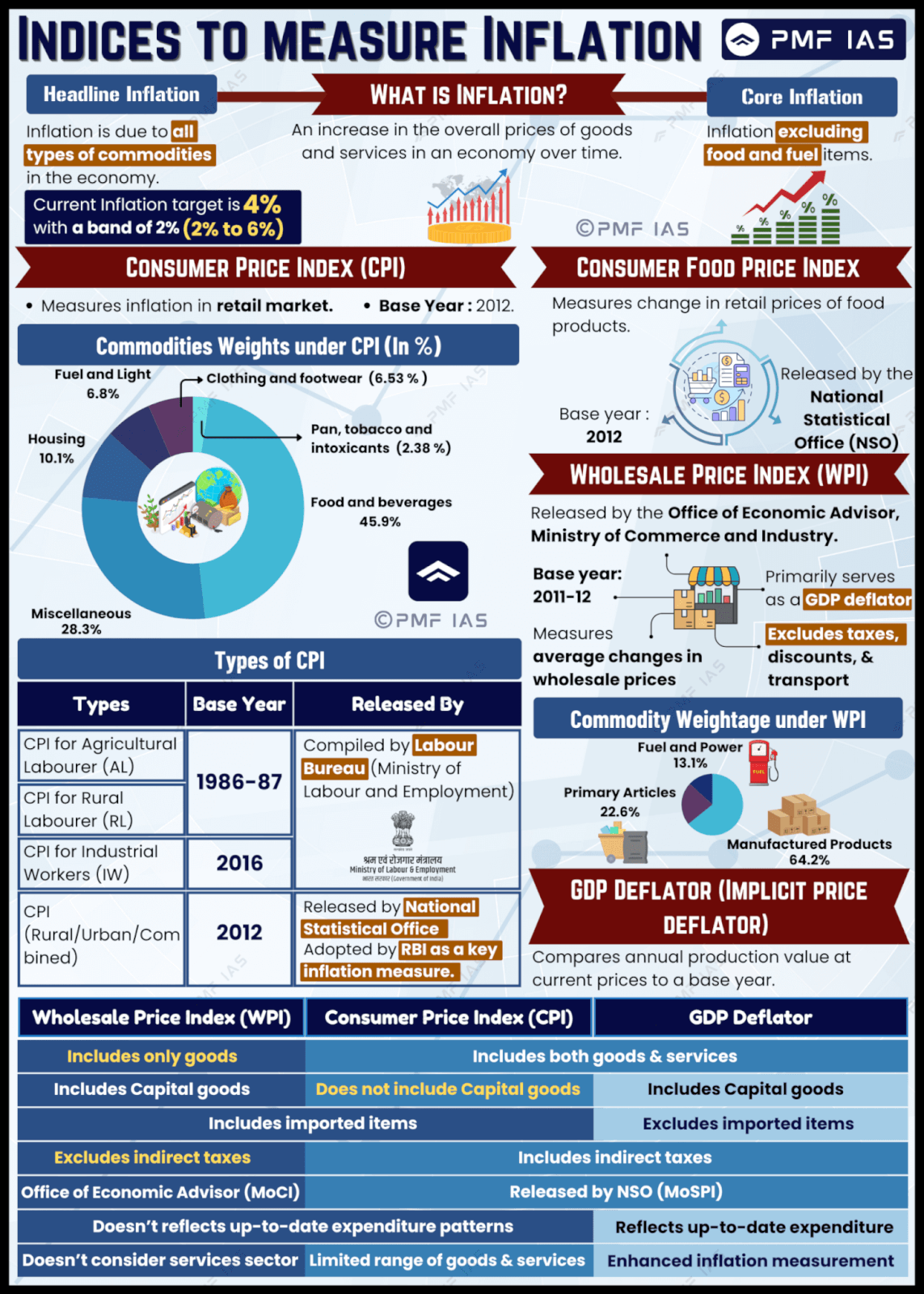
- Food accounts for 45.9% of the weight in the Consumer Price Index (CPI-Combined), compared to 24.4% in the Wholesale Price Index (WPI).
Statement 2 is correct
- The two indices also differ in including non-tradable services such as health, education, recreation, and amusement. While the WPI excludes services completely, services comprise 28.32 per cent of the CPI.
Statement 3 is incorrect
- The Reserve Bank of India (RBI) has adopted the Consumer Price Index (CPI) (combined) as the key measure of inflation. Earlier, the RBI had given more weightage to the Wholesale Price Index (WPI) than the CPI as the key measure of inflation for all policy purposes. It was one of the recommendations of the Urjit R. Patel Committee.
Answer: (a) 1 and 2 only; Difficulty Level: Medium
Consider the following pairs:
| River |
Flows into |
| 1.Mekong |
Andaman Sea |
| 2.Thames |
Irish Sea |
| 3.Volga |
Caspian Sea |
| 4.Zambezi |
Indian Ocean |
Which of the Pairs given above is/are correct?
- 1 and 2 only
- 3 only
- 3 and 4 only
- 1, 2 and 4 only
Explanation
Pair 1 is incorrect
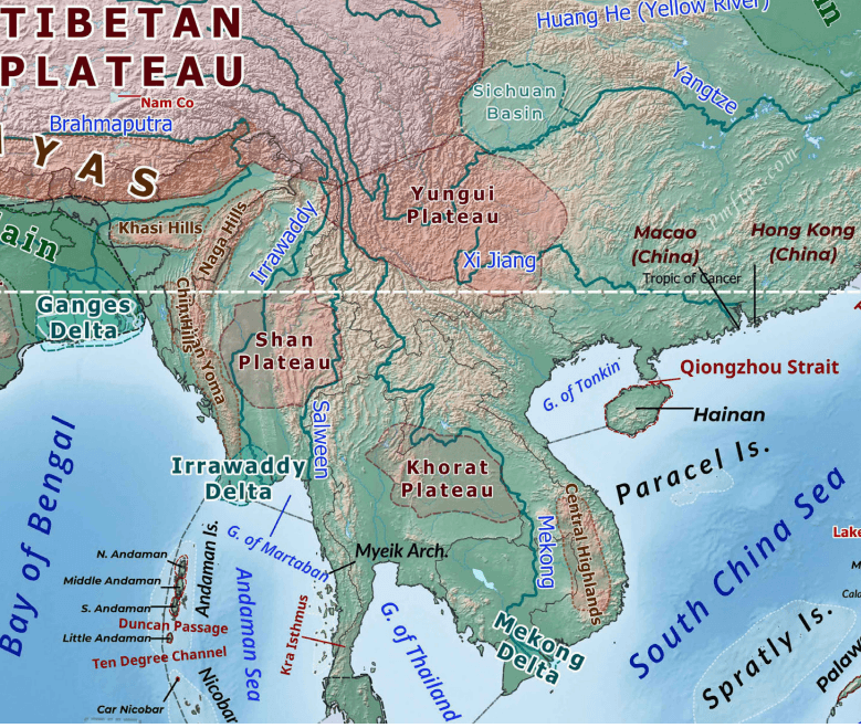
- The Mekong River, known as the Lancang River in China, is a major transboundary river in Southeast Asia and is the twelfth longest river in the world and seventh longest in Asia, with an estimated length of about 4,350 km. Originating from the Tibetan Plateau, it flows through China → Myanmar → Laos → Thailand → Cambodia → Vietnam before draining into the South China Sea through the Mekong Delta. Along its course, the river also forms parts of the international borders between Myanmar and Laos, and Laos and Thailand.
Pair 2 is incorrect
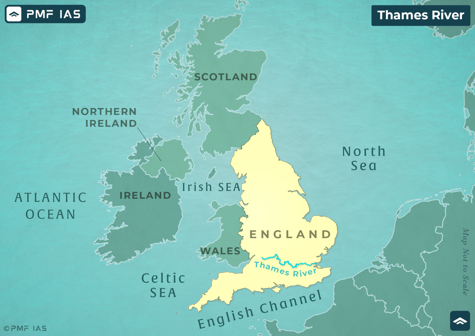
- The River Thames is a 346 km river that flows through southern England. The river passes numerous popular cities, such as London, Reading, Hendley-on-Thomas, Windsor and Oxford, where it is also called the Isis River, and flows into the North Sea via the Thames Estuary.
Pair 3 is correct
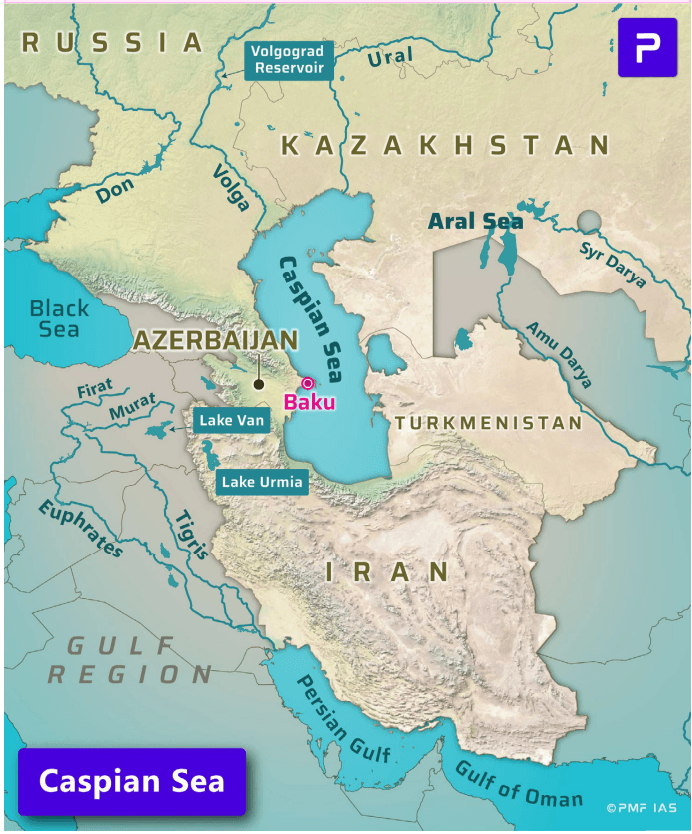
- Europe’s longest river and the principal waterway of Russia, the Volga arises in the Valdai Hills northwest of Moscow and flows southeastward for 2,325 miles (3,740 kilometers) to empty into the Caspian Sea.
Pair 4 is correct
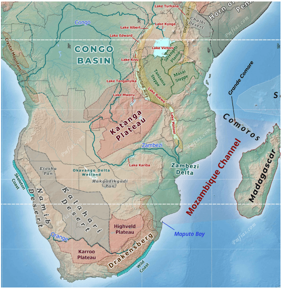
- The Zambezi (also Zambeze) is the fourth largest river in Africa, and the largest east-flowing waterway. From headwaters in Zambia, it rolls across 2,574 kilometres (1,599 miles) of the south-central African plateau before pouring water and sediment into the Indian Ocean through a vast delta in Mozambique.
- Victoria Falls is located on the Zambezi River in Africa, straddling the border of Zambia to the east and Zimbabwe to the west.
Answer: (c) 3 and 4 only; Difficulty Level: Hard
Consider the following statements:
- In the case of all cereals, pulses and oil seeds, the procurement at Minimum Support Prices (MSP) is unlimited in any State/UT of India.
- In the case of cereals and pulses, the MSP is fixed in any State/UT at a level to which the market price will never rise.
Which of the statements given above is/are correct?
- 1 only
- 2 only
- Both 1 and 2
- Neither 1 nor 2
Explanation
Statement is correct
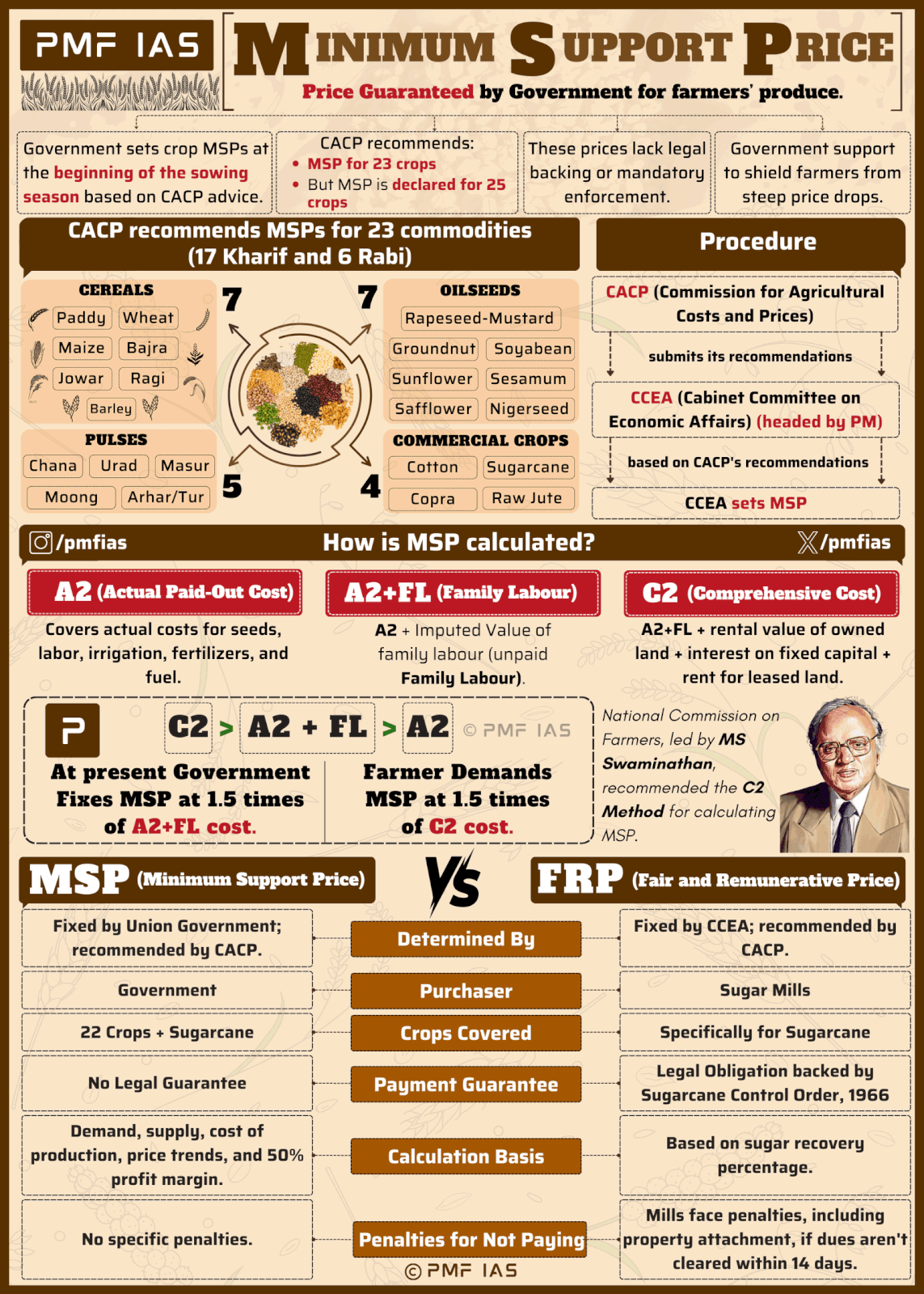
- The procurement at Minimum Support Prices (MSP) is not unlimited. The government typically purchase certain quantities based on its needs and budgetary constraints. This applies differently for cereals, pulses, and oilseeds.
- For example, the government’s procurement of pulses and oilseeds under the scheme has gradually increased. Initially, it was mandated to buy only 25% of production. This limit was later raised to 40%. Most recently, for the 2023-24 season, the cap was entirely removed for arhar, urad, and masoor.
Statement 2 is incorrect
- The MSP is a price floor set by the government to ensure farmers are protected from any sharp fall in market prices, but it is not true that the market price will “never rise” above the MSP. Market prices can and do fluctuate above the MSP based on supply and demand dynamics.
- The MSP is fixed by the Central government on the recommendations of the Commission for Agricultural Costs and Prices (CACP).
Answer: (d) Neither 1 nor 2; Difficulty Level: Easy
With reference to the Indian economy, consider the following statements:
- ‘Commercial Paper’ is a short-term unsecured promissory note.
- ‘Certificate of Deposit’ is a long-term instrument issued by the Reserve Bank of India to a corporation.
- ‘Call Money’ is a short-term finance used for interbank transactions.
- ‘Zero-Coupon Bonds’ are the interest bearing short-term bonds issued by the Scheduled Commercial Banks to corporations.
Which of the statements given above is/are correct?
- 1 and 2 only
- 4 only
- 1 and 3 only
- 2, 3 and 4 only
Explanation
Statement 1 is correct
- Commercial paper is an unsecured, short-term debt instrument issued by corporations to meet immediate financial needs such as payroll, accounts payable, and inventory financing. It is typically issued at a discount to its face value, and investors earn returns from the difference between the purchase price and the face value at maturity. Although commercial paper carries lower credit risk than many other short-term instruments, it generally offers higher yields, making it an attractive option for investors seeking short-term returns.
Statement 2 is incorrect
- Certificates of Deposit (CDs) are negotiable money market instruments issued in demat form or as Usance Promissory Notes by banks and financial institutions. Banks issue CDs with maturities ranging from 7 days to 1 year, while financial institutions can issue them for 1 year to 3 years. CDs function similarly to bank term deposits; however, unlike traditional time deposits, they are freely negotiable, and hence are often referred to as Negotiable Certificates of Deposit. They typically offer higher returns than bank term deposits, making them attractive to investors. Additionally, CDs are rated by approved credit rating agencies such as CRISIL, ICRA, CARE Ratings, and Fitch Ratings, which enhances their credibility and improves their tradability in the secondary market depending on demand.
Statement 3 is correct
- Call Money is a very short–term loan, usually overnight, utilised by banks to fulfil urgent liquidity requirements. It operates within the money market, facilitating short-term borrowing and lending between banks, known as interbank transactions. It allows banks to earn interest, known as the call loan rate, on their surplus funds.
Statement 4 is incorrect
- A zero-coupon bond, also known as an accrual bond, is a debt security that does not pay interest but instead trades at a deep discount, rendering a profit at maturity, when the bond is redeemed for its full-face value.
Answer: (c) 1 and 3 only; Difficulty Level: Hard
With reference to the cultural history of India, consider the following pairs:
| 1.Parivrajak |
Renunciant and wanderer |
| 2.Shramana |
Priest with a high status |
| 3.Upasaka |
Lay follower of Buddhism |
Which of the pairs given above are correctly matched?
- 1 and 2 only
- 1 and 3 only
- 2 and 3 only
- 1,2 and 3
Explanation
Pair 1 is correct, and pair 2 is incorrect
- Vedic literature and some texts like the Aranyakas and Upanishads were overly concerned with asceticism.
- Tapasvin, sramana, sanyasin, parivrajaka, yogi are some of the terms that we come across in the texts. They were all renouncers who, having given up on the pleasures of life, had taken to a life of austerity.
- They were given to controlling the functions of the body (breathing mainly) and wandering from place to place in search for the Ultimate Truth.
- Parivrajaka was a young man who had taken to the life of a wanderer for a short while before becoming a grihastha. But more often, parivrajaka was a state of permanent renunciation.
Pair 3 is correct
- According to the teachings of Buddha, an individual who takes refuge in the three gems – namely, the Buddha, the Dhamma, and the Saṅgha – is referred to as a lay devotee. An Upasaka, in particular, is a layman who not only embraces the three refuges but also upholds ethical precepts and sustains himself through honourable means of livelihood. In simple terms, it refers to any Buddhist who is not a member of a monastic order.
Answer: (b) 1 and 3 only; Difficulty Level: Easy
With reference to Indian Elephants, consider the following statements:
- The leader of an elephant group is a female.
- The maximum gestation period can be 22 months.
- An elephant can normally go on calving till the age of 40 years only.
- Among the States in India, the highest elephant population is in Kerala.
Which of the statements given above is/are correct?
- 1 and 2 only
- 2 and 4 only
- 3 only
- 1, 3 and 4 only.
Explanation
Statement 1 is correct
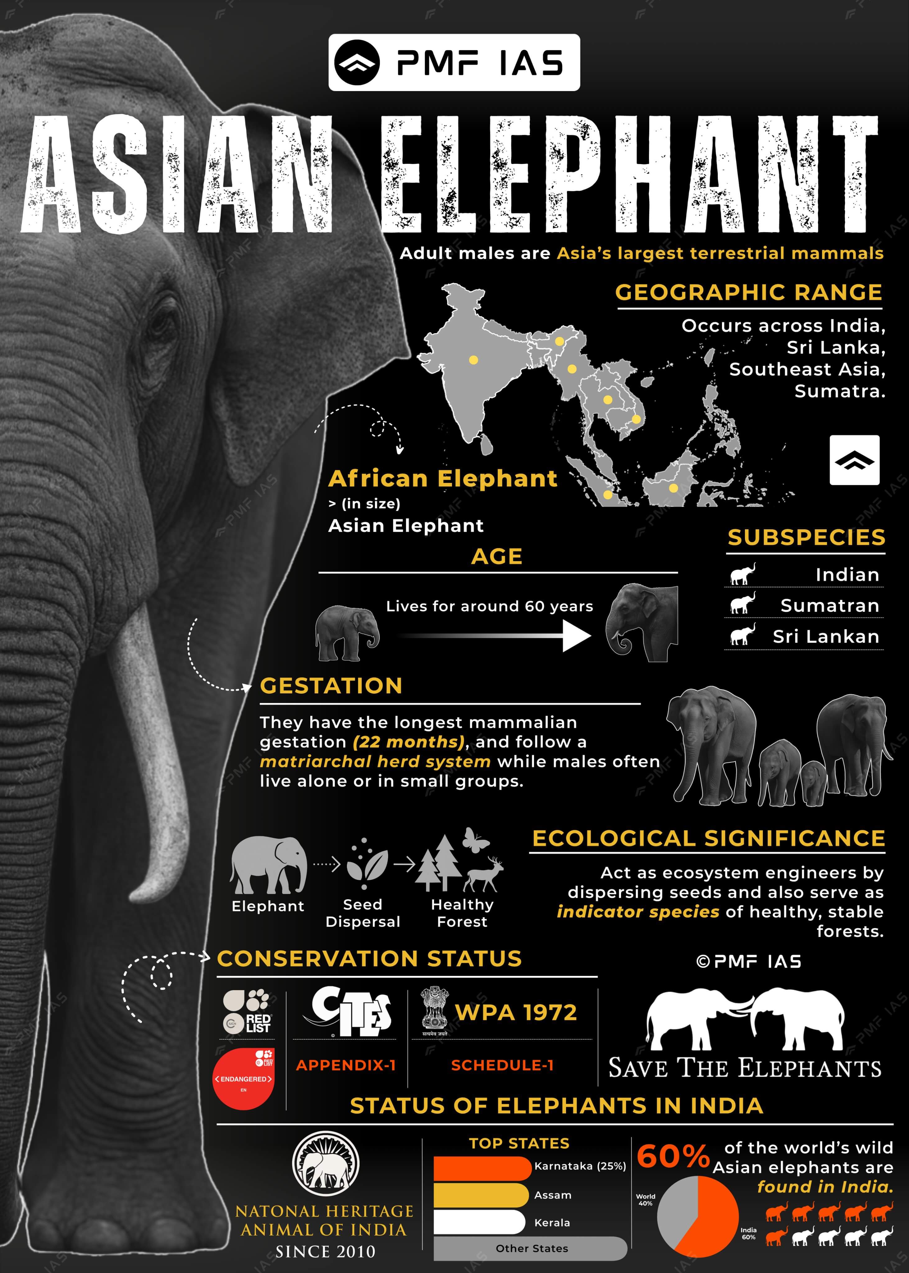
- Elephants are matriarchal, meaning they live in female-led groups.
Statement 2 is correct
- The elephant’s gestation period is 18 to 22 months, and the calf is nursed for 2 to 4 years. The lifespan of elephants is 60-70 years in the wild.
Statement 3 is incorrect
- Elephants can reproduce beyond the age of 40, with some elephants calving even in their 50s. There is no clear-cut age in Asian elephants after which further reproduction is impossible. Instead, fertility may be greatly reduced at old ages but still greater than zero.
Statement 4 is incorrect
- India is home to 60% of the Asian elephant population.
- India states with highest elephant population: 1st Karnataka (25%) > 2nd Assam > 3rd Kerala > 4th Tamil Nadu > 5th Odisha > 6th Uttarakhand.
- The Indian subspecies has the widest range among Asian elephants.
- India declared the elephant a national heritage animal by acknowledging its ecological sensitivity.
Additional Information
- There are three species of elephants: African Forest Elephant (CR), African Savanna Elephant (EN), and Asian Elephant (EN).
- There are three subspecies of Asian elephant: Indian, Sumatran, and Sri Lankan.
|
Answer: (a) 1 and 2 only; Difficulty Level: Hard
Which of the following Protected Areas are located in the Cauvery basin?
- Nagarhole National Park
- Papikonda National Park
- Sathyamangalam Tiger Reserve
- Wayanad Wildlife Sanctuary
Select the correct answer using the code given below:
- 1 and 2 only
- 3 and 4 only
- 1, 3 and 4 only
- 1, 2, 3 and 4
Explanation
Nagarhole National Park is correct
- Nagarhole National Park is located in the foothills of the Western Ghats. It is recognised as an Important Bird Area. Jenu Kurubas (honey-collecting tribe) live in this park.
- Vegetation: Moist & dry deciduous forests, swamp forests, and bamboo.
- Major Flora: Rosewood, teak, sandalwood and silver oak.
- Major Fauna: Bengal tiger, leopard, Indian elephant, chital, chausingha, gaur, mugger (marsh crocodile).
- Threats: Tourism, fragmentation of forests, and poaching.
- Nagarahole River flows through the park and gradually joins the Kabini River (a tributary of the Cauvery), which is also a boundary between Nagarahole and Bandipur
Papikonda National Park is incorrect
- Papikonda National Park, located in the Papi Hills across the East Godavari and West Godavari districts of Andhra Pradesh, India, is part of the Eastern Ghats and lies within the Godavari river basin. It is an Important Bird and Biodiversity Area.
- Major Fauna: Bengal tiger, leopard, hyena, Indian gaur, sloth bear, spotted deer (chital), sambar, barking deer (or Indian muntjac), four-horned antelope (chausingha), kanchu mekha (an endemic dwarf goat).
- Major Avifauna: Common peacock, red jungle fowl.
- Major Reptiles: Indian golden gecko, monitor lizard.
- The National Park has a population of both Rhesus macaque (normally found north of Godavari) and Bonnet macaque (usually found south of Godavari).
- Threats: Polavaram irrigation project (will submerge parts of the National Park), and clearing forest for Podu cultivation.
Sathyamangalam Tiger Reserve is correct
- Located in Tamil Nadu’s Erode District and part of the Nilgiri Biosphere Reserve, is crossed by the Bhavani River, a tributary of the Cauvery River.
- Sathyamangalam Tiger Reserve = Sathyamangalam + Hasanur Forest Divisions.
- It is a wildlife corridor in the Nilgiris Biosphere Reserve between the Western Ghats and the Eastern Ghats and a genetic link between BR Hills Wildlife Sanctuary, Mudumalai National Park and Bandipur National Park.
- Vegetation: Dry deciduous forest and grasslands.
- Major Fauna: Bengal tiger, elephant, gaur, leopard, spotted deer, blackbuck, sambar deer, barking deer.
- Threats: Rampant poaching of tigers and elephants.
Wayanad Wildlife Sanctuary is correct
- The Kabini River, a tributary of the Cauvery River, flows through the Wayanad Wildlife Sanctuary. It is an integral part of the Nilgiri Biosphere Reserve. It is bounded by Nagarhole National Park and Bandipur National Park (Karnataka) and Mudumalai National Park.
Answer: (c) 1, 3 and 4 only; Difficulty Level: Hard
With reference to India’s Biodiversity, Ceylon frogmouth, Coppersmith barbet, Gray-chinned minivet, and White-throated redstart are
- Birds
- Primates
- Reptiles
- Amphibians
Explanation
Ceylon frogmouth
- The Ceylon frogmouth is a species endemic to the Western Ghats, occasionally sighted in Brahmagiri and parts of Dakshina Kannada. It is a nocturnal bird recently recorded for the first time in Uttara Kannada. Frogmouths prefer dense woods and are primarily found in pairs. The bird measures about 9 inches with a wide beak and split nostrils, resembling a frog. The male is predominantly greyish brown, while the female is chestnut brown.
- IUCN Status: Least Concern
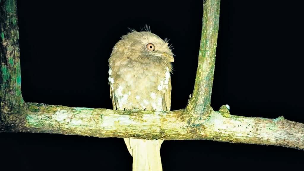
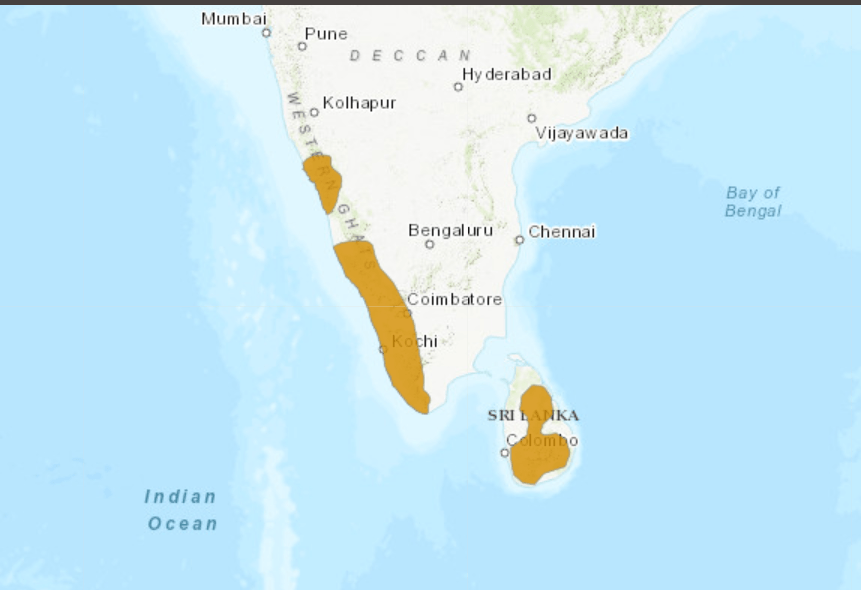
Image Source: Indian Express
Coppersmith barbet
- Coppersmith Barbet (Psilopogon haemacephalus) is a small, approximately 17 cm bird with a distinctive chunky appearance and green plumage. It belongs to the family Megalaimidae (Asian Barbets) and the order Piciformes, which also includes woodpeckers. They are sexually monochromatic, meaning both males and females look alike, and are often observed climbing tree trunks, similar to woodpeckers. The species is a cavity nester, often competing with other birds like mynas for nesting sites.
- Habitat: Prefers open wooded areas, groves, and wooded urban gardens.
- They are a diurnal bird.
- IUCN Status: Least Concern
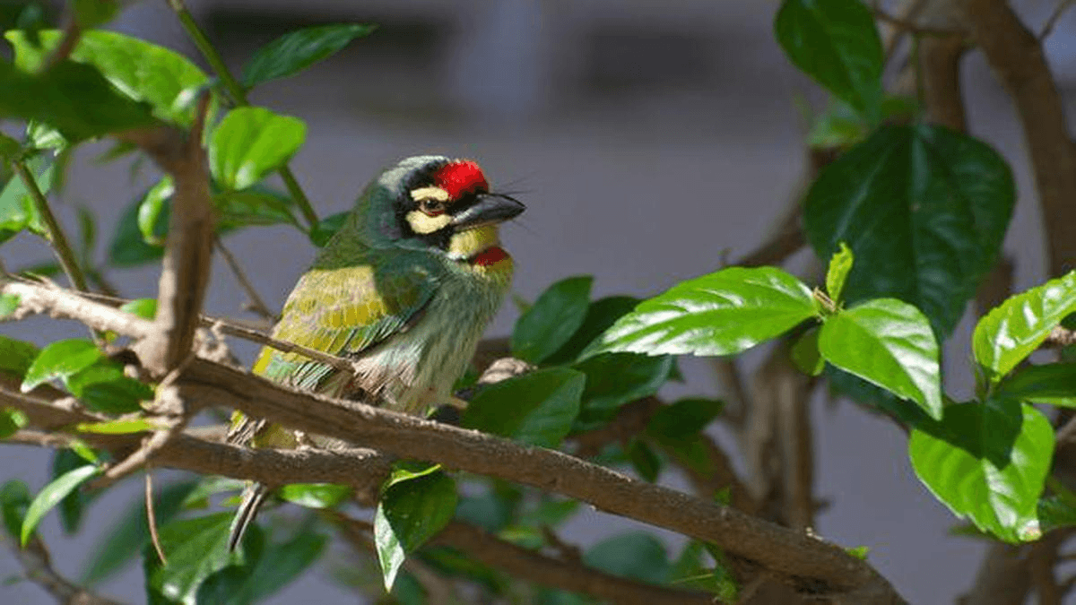
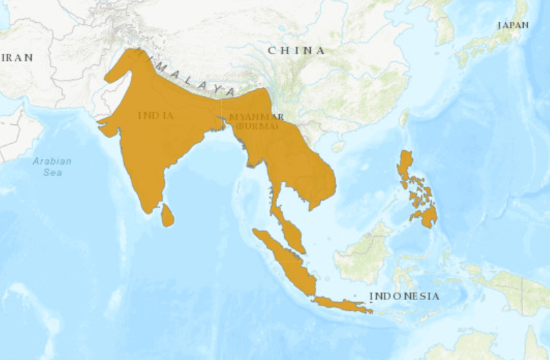
Image Source: The Hindu
Gray-chinned minivet
- The grey-chinned minivet (Pericrocotus solaris) is a species of bird in the family Campephagidae. It is found from the Himalayas to China, Taiwan and Southeast Asia. Its natural habitat is forests about 1,000–2,000 m (3,300–6,600 ft) in elevation.
- IUCN Status: Least-concern
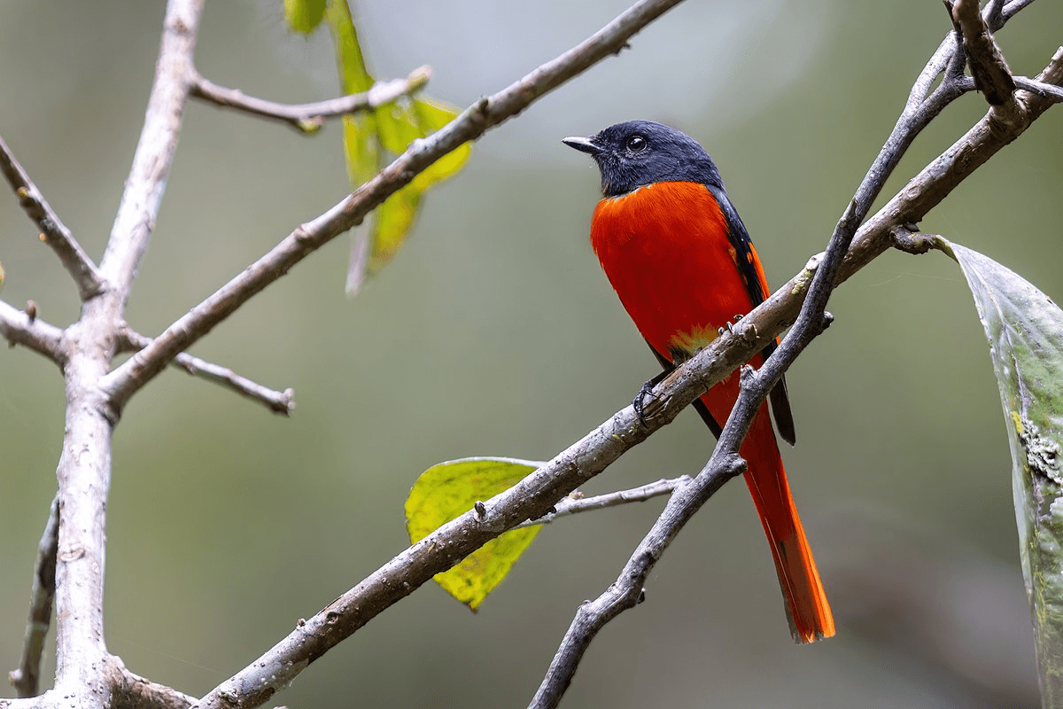
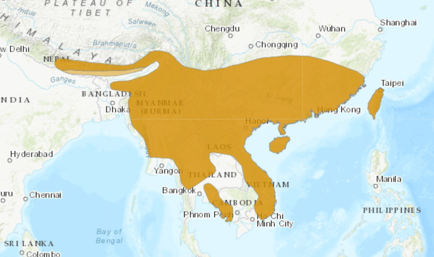 Image Source: IUCN
White-throated redstart
- The white-throated redstart (Phoenicurus schisticeps) is a species of bird in the family Muscicapidae. It is found in Nepal, Bhutan, central China and far northern areas of Myanmar and Northeast India. Its natural habitat is temperate forests.
- IUCN Status: Least Concern
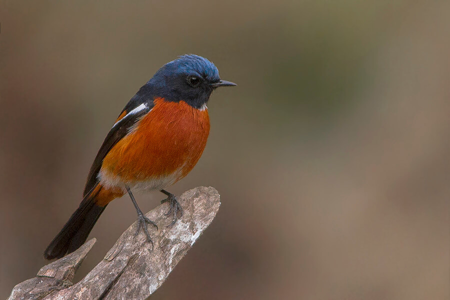
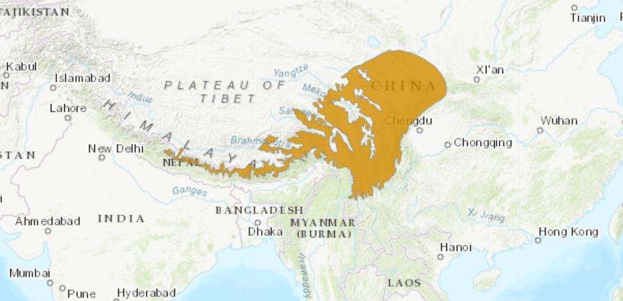
Image Source: IUCN
Answer: (a) Birds; Difficulty Level: Hard
Which one of the following protected areas is well known for the conservation of a sub-species of the Indian swamp deer (Barasingha) that thrives well on hard ground and is exclusively graminivorous?
- Kanha National Park
- Manas National Park
- Mudumalai Wildlife Sanctuary
- Tal Chhapar Wildlife Sanctuary
Explanation
Option (a) is correct
- Hard ground swamp deer (Barasingha or Rucervus duvaucelii, IUCN: VU) is the state animal of Madhya Pradesh. It has seen a revival in the Kanha National Park and Tiger Reserve (KNPTR) after near-extinction. Successful breeding programs and conservation efforts helped in the species’ recovery at KNPTR. Swamp deer are extinct in Pakistan and Bangladesh, now found only in southwestern Nepal and central/northeastern India.
- There are three subspecies of swamp deer in the Indian Subcontinent:
- Western swamp deer (Rucervus duvaucelii) found in Nepal.
- Southern swamp deer (Rucervus duvaucelii branderi) found in central and north India.
- Eastern swamp deer (Rucervus duvaucelii ranjitsinhi) found in Kaziranga and Dudhwa National Parks.
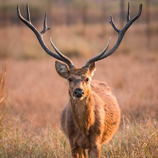
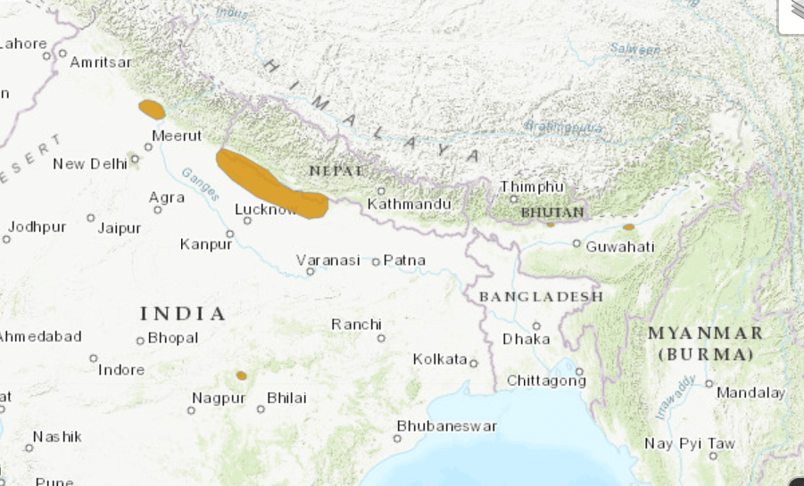
Image Source: IUCN
Additional information
- Kanha National Park, Tiger Reserve, is located in the Maikal Range of Satpuras. It is the largest national park in Madhya Pradesh and Central India. The present-day Kanha area is divided into two protected areas, Hallon and Banjar.
- Tribes displaced from the region: Baiga tribe (a semi-nomadic tribe of Central India) lost their forest rights & were not properly compensated.
- Vegetation: tropical moist and dry deciduous forests.
- Major Flora: Sal, bamboo forests.
- Major Fauna: Bengal tiger, gaur, barasingha (swamp deer; VU), dhole, spotted deer, sambar, chausingha.
- Major Avifauna: Black ibis, Indian grey hornbill, lesser adjutant, steppe eagle.
|
Option (b) is incorrect
- Manas National Park is a UNESCO Natural World Heritage site located on the Himalayan Foothills. It is contiguous with the Royal Manas National Park (Bhutan).
- Manas River (a tributary of Brahmaputra) passes through the heart of the National Park.
- The bhabar-terai region with riverine succession makes it one of the richest areas of biodiversity.
- Vegetation: Semi-evergreen forests, moist & dry deciduous forests, savanna woodland, & grasslands.
- Major Fauna: Hispid hare, pygmy hog, wild water buffalo, rhinoceros (reintroduced in 2007), elephants, sambar, Chinese pangolin, clouded leopards.
- Major Avifauna: It has the world’s largest population of the endangered Bengal florican. Other major bird species include great hornbills, pelicans, eagles, and herons.
Option (c) is incorrect
- Mudumalai Wildlife Sanctuary lies on the north-western side of the Nilgiri Hills (Blue Mountains), in Nilgiri district. It shares its boundaries with the states of Karnataka and Kerala.
- Vegetation: tropical moist deciduous, dry deciduous and dry thorn forests.
- Major Fauna: Indian elephant, Bengal tiger, leopard, bonnet macaque, sloth bear, sambar, Indian giant squirrel.
- Avian Major Fauna: Indian white-rumped vulture (CR) and Indian Vulture (CR). Threats: Tourism and invasive species such as Lantana.
Option (d) is incorrect
- Located in the Churu district of Rajasthan, it is known for blackbucks (LC).
Answer: (a) Kanha National Park; Difficulty Level: Easy
Steel slag can be the material for which of the following?
- Construction of base road
- Improvement of agricultural soil
- Production of cement
Select the correct answer using the code given below:
- 1 and 2 only
- 2 and 3 only
- 1 and 3 only
- 1, 2 and 3
Explanation
The construction of the base road is correct
- Steel slag, a by-product of steel making, is produced during the separation of the molten steel from impurities in steel-making furnaces. The slag occurs as a molten liquid and is a complex solution of silicates and oxides that solidifies upon cooling.
- Steel slag is used as a material in the construction of base layers for roads and highways. Its strong, dense, and durable nature ensures it provides a stable foundation. Moreover, it has excellent drainage properties, making it ideal for use in road construction, particularly in areas with high moisture levels.
- India’s First Steel Slag Road was built at Hazira, Surat, by AMNS India and CSIR-CRRI in April 2022. Countries like the USA and Japan use slags extensively (more than 70% of the output) in areas such as housing, road construction, and land and mine filling.
Improvement of agricultural soil is correct
- The use of steel slag as fertilisers and soil nutrients is gaining importance across the globe as it represents an eco-friendly application wherein the advantages of the chemical properties of steel-making slag can be utilised to promote the growth of plants and increase the yield of agricultural products, particularly in areas where the soil is acidic. Developed countries like Japan and the USA have taken the lead in producing fertilisers such as slag silicate fertiliser, by-product lime fertiliser, slag phosphate fertiliser, or iron matter of special fertiliser using steel-making slag.
Production of cement is correct
- Steel slag can be used in cement production as a supplementary cementitious material. The slag’s chemical composition helps improve the strength and durability of the cement.
Answer: (d) 1, 2 and 3; Difficulty Level: Medium
Which of the following are the most likely places to find the musk deer in its natural habitat?
- Askot Wildlife Sanctuary
- Gangotri National Park
- Kishanpur Wildlife Sanctuary
- Manas National Park
Select the correct answer using the given code below
- 1 and 2 only
- 2 and 3 only
- 3 and 4 only
- 1 and 4 only
Explanation
Askot Wildlife Sanctuary is correct
- It is located in the Pithoragarh district of Uttarakhand. This sanctuary has been set up for conserving the musk deer (EN).
Additional Information: Himalayan Musk Deer / White-Bellied Musk Deer
- India is home to four species of Musk Deer, all of which are distributed across the Himalayan region.
- These species include the Himalayan the white-bellied musk deer (Moschus leucogaster), the Kashmir Musk Deer (Moschus cupreus), the Alpine Musk Deer (Moschus chrysogaster), and the Black Musk Deer (Moschus fuscus).
- The white-bellied musk deer is the state animal of Uttarakhand.
- The Musk deer family differs from true deer (cervids) in that it lacks antlers.
- Male musk deer secretes a scented substance called musk, which is used in the perfume industry.
- Distribution: Himalayas of Bhutan, India, Nepal, and China.
- Habitat: High alpine environments.
- Threats: Hunting (for musk) and habitat loss.
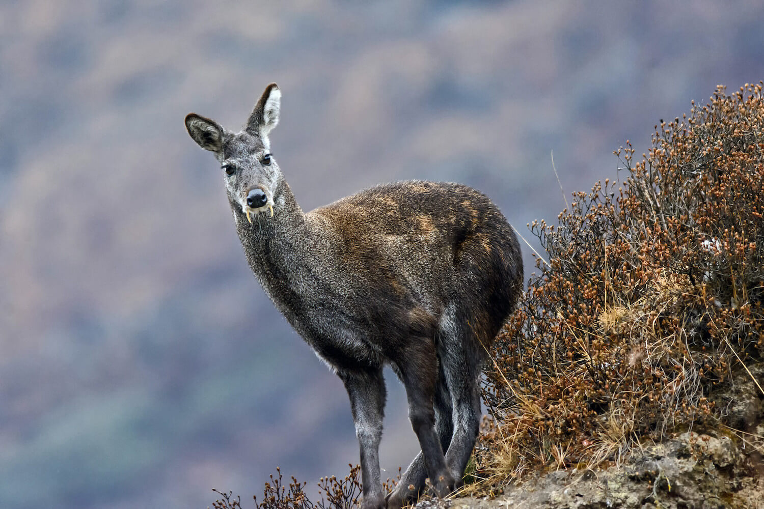 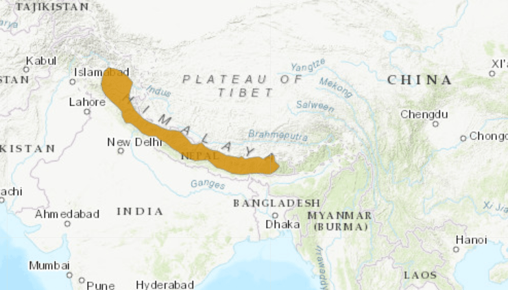
Image source: IUCN
|
Gangotri National Park is correct
- It is located in the upper catchment of the Bhagirathi River. The park area forms a continuity between Govind National Park and Kedarnath Wildlife Sanctuary.
- The Gaumukh glacier, the origin of the river Ganges is located inside the park.
- Habitat: Coniferous forests, alpine meadows and glaciers.
- Vegetation: Pine, deodar, fir, and rhododendrons.
- Major Fauna: Snow leopard, Asian black bear, brown bear, musk deer, blue sheep, Himalayan tahr.
Kishanpur Wildlife Sanctuary is incorrect
- It is contiguous with the Pilibhit Tiger Reserve.
- The Sarda River (known as Kali River before it reaches the plains; it flows along the Indo-Nepal Border) separates Kishanpur Wildlife Sanctuary from the Dudhwa National Park.
- Major Fauna: Swamp deer (VU), Bengal florican (CR), Lesser Florican (CR).
Manas National Park is incorrect
- It is a UNESCO Natural World Heritage site located on the Himalayan Foothills. It is contiguous with the Royal Manas National Park (Bhutan). Manas River (a tributary of Brahmaputra) passes through the heart of the National Park. The bhabar-terai region with riverine succession makes it one of the richest areas of biodiversity.
- Vegetation: Semi-evergreen forests, moist & dry deciduous forests, savanna woodland, & grasslands.
- Major Fauna: Hispid hare, pygmy hog, wild water buffalo, rhinoceros (reintroduced in 2007), elephants, sambar, Chinese pangolin, clouded leopards.
- Major Avifauna: It has the world’s largest population of the endangered Bengal florican. Other major bird species include great hornbills, pelicans, eagles, and herons.
Answer: (a) 1 and 2 only; Difficulty Level: Medium
- Copper slag
- Cold mix asphalt technology
- Geotextiles
- Hot mix asphalt technology
- Portland cement
Select the correct answer using the given code below
- 1, 2 and 3 only
- 2, 3 and 4 only
- 4 and 5 only
- 1 and 5 only
Explanation
Copper slag is correct
- Copper slag, a by-product of the copper smelting process, offers a prime example of waste being converted into wealth and contributing to environmental sustainability. Generated during the extraction of copper from sulphide ore, copper slag primarily consists of iron silicates. India alone produces approximately 22.17 million tons of copper slag annually from companies like Birla Copper, Sterlite Copper, and Hindustan Copper, while globally, 400 million tons are generated each year.
- Contrary to common misconceptions, copper slag is not classified as hazardous waste. Regulatory bodies such as the US Environmental Protection Agency (US EPA) have declared it non-hazardous, after extensive studies. In India, the Bureau of Indian Standards (BIS) and the Indian Roads Congress (IRC) have approved the use of copper slag in various applications, including road construction, cement blending, and concrete production. In construction, copper slag improves the strength of concrete when used as a substitute for sand and gravel. Its inert nature, stability, and poor leachability ensure minimal environmental impact, even in large-scale usage. The material is also known to reduce the carbon footprint in construction.
Cold mix asphalt technology is correct
- This method uses asphalt emulsions that don’t require heating, significantly reducing energy consumption during production and construction compared to traditional hot mix asphalt. Additionally, cold mix asphalt can often incorporate recycled materials, further lowering its environmental impact.
Geotextiles is correct
- Geotextiles are permeable fabrics that, when combined with soil, serve functions such as separation, filtration, reinforcement, protection, and drainage. Commonly made from synthetic polymers or natural fibres, they improve soil stability and drainage in road construction. By reducing the dependence on natural aggregates, geotextiles help extend the lifespan of roads, decreasing the need for frequent repairs and maintenance, and thus contributing to sustainability.
Hot mix asphalt technology is incorrect
- As mentioned earlier, this method requires significant energy for heating the asphalt, leading to higher carbon emissions compared to cold mix.
Portland cement is incorrect
- While commonly used in construction, its production is energy-intensive and contributes significantly to carbon emissions.
Answer: (a) 1, 2 and 3 only; Difficulty Level: Medium
Consider the following statements
- Coal ash contains arsenic, lead and mercury.
- Coal fired power plants release sulphur dioxide and oxides of nitrogen into the environment.
- High ash content is observed in Indian Coal.
Which of the above given statements is/are correct?
- 1 only
- 2 and 3 only
- 3 only
- 1, 2 and 3
Explanation
Statement 1 is correct
- Coal ash, a catchall term for several kinds of waste left over at power plants that burn coal, typically contains a number of substances harmful to human health—arsenic, chromium, lead, and mercury among them.
Statement 2 is correct
- Burning coal releases various pollutants, including sulfur dioxide (SO2) and nitrogen oxides (NOx), which contribute to acid rain, smog, and respiratory problems
Statement 3 is correct
- Ash content of coal produced in the country is generally 25 to 45 %, whereas the average ash content of imported coal varies from 10 to 20 %.
Answer: (a) 1, 2 and 3 only; Difficulty Level: Easy
What is the use of Biochar in farming?
- Biochar can be used as a part of the growing medium in the vertical farming
- When biochar is a part of the growing medium, it promotes the growth of nitrogen fixing microorganisms.
- When biochar is a part of the growing medium, it enables the medium to retain water for a longer time.
Which of the above given statements is/are correct?
- 1 and 2 only
- 2 only
- 1 and 3 only
- 1, 2 and 3 only
Explanation
Statement 1 is correct
- Biochar is utilised in vertical farming to improve soil quality and support plant growth.
Statement 2 is correct
- Biochar provides a habitat for beneficial microorganisms, including those that fix nitrogen, which enhances soil fertility.
Statement 3 is correct
- Biochar improves water retention in the soil.
- Concerns with Biochar: Contaminated feedstocks may transfer pollutants like heavy metals into biochar.
- During pyrolysis, carbon-containing gases are emitted, mainly volatile organic carbon species (VOC), carbon monoxide, and aerosols.
- It can alter soil pH, affect nutrient availability, and disrupt microbial communities.
Additional Information
- Biochar is charcoal that is used as a soil amendment (minor improvement). It is created by pyrolysis (decomposition at high temperatures), heating biomass in a low-oxygen environment. Once the pyrolysis reaction has begun, it is self-sustaining and requires no external energy input.
- By-products of the process include syngas (H2 + CO), minor quantities of methane (CH4), organic acids and excess heat. The syngas and excess heat can be used directly or employed to produce a variety of biofuels.
- Benefits of Biochar:
- Improves soil health: It improves soil structure, water retention, and nutrient-holding capacity.
- Carbon sequestration: It is a stable form of carbon that can be stored for centuries.
- Reduces water pollution: It can filter out pollutants from water, such as pesticides and heavy metals.
- It can reduce the amount of pathogens in the soil.
- It can reduce emissions by 70% as compared to open stubble burning.
|
Answer: (a) 1, 2 and 3 only; Difficulty Level: Easy
If a particular plant species is placed under Schedule VI of the Wildlife Protection Act,1972, what is the implication?
- licence is required to cultivate that plant.
- Such a plant cannot be cultivated under any circumstances.
- It is a Genetically Modified crop plant.
- Such a plant is invasive and harmful to the ecosystem.
Explanation
Option (a) is correct
- Schedule VI of the Act includes certain plant species whose cultivation and planting are prohibited without a license. Therefore, if a plant species is listed under Schedule VI, obtaining a license is mandatory for its cultivation. The Act was amended in 2022, with the Wild Life (Protection) Amendment Act, 2022, which came into effect from April 1, 2023. Among other significant changes, it also reduced the number of schedules from six to four.
- In the amendment act:
- Schedule I specifies the animal species with the highest level of protection,
- Schedule II specifies the animal species with a relatively lower degree of protection.
- Schedule III in the amendment act is for plant species and
- Schedule IV is for species protected under the Convention on International Trade in Endangered Species of Wild Fauna and Flora (CITES).
Answer: (a) licence is required to cultivate that plant; Difficulty Level: Hard
With reference to the period of Gupta dynasty in ancient India, the towns Ghantasala, kadura and Chaul were well known as
- ports handling foreign trade.
- capitals of powerful kingdoms.
- places of exquisite stone art and architecture.
- important Buddhist pilgrimage centres.
Explanation
Option (a) is correct
- Prominent sea ports of the Gupta era included Tamralipti, Arikamedu, Muziris, Sopara, Chaul (23 miles to the south of Mumbai, West coast), kadura, and Kontakossylla (Ghantasala, Andhra coast) all of which were well connected via inland routes across the Gupta Empire.
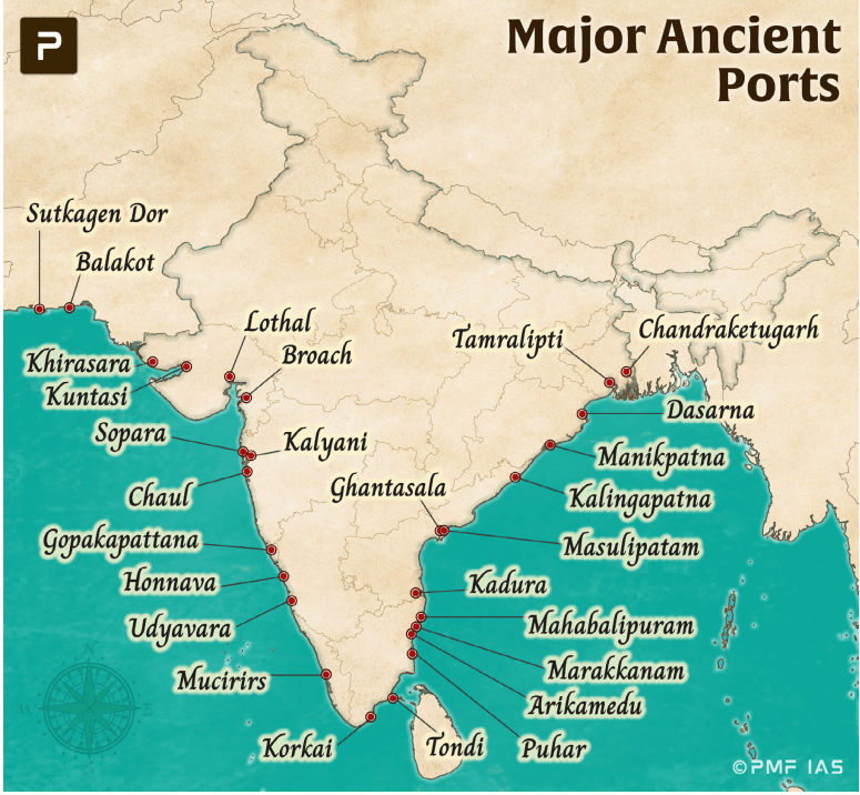
Answer: (a) ports handling foreign trade; Difficulty Level: Medium
What is/are the advantage/advantages of zero tillage in agriculture?
- Sowing of wheat is possible without burning the residue of the previous crop.
- Without the need for a nursery of rice saplings, direct planting of paddy seeds in the wet soil is possible.
- Carbon sequestration in the soil is possible.
Select the correct answer using the code given below:
- 1 and 2 only
- 2 and 3 only
- 3 only
- 1, 2 and 3 only
Explanation
Statement 1 is correct
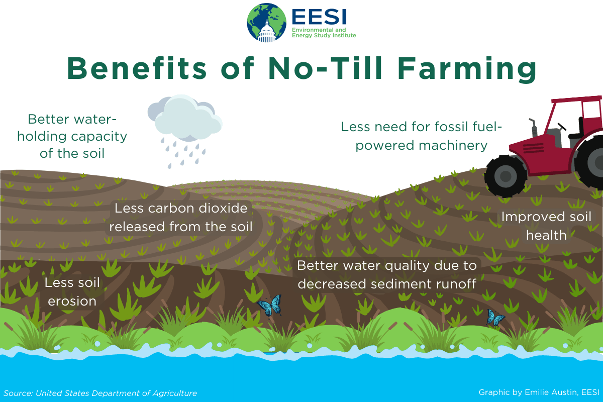
- Zero tillage is the process where the crop seed will be sown through drillers without prior land preparation and disturbing the soil where previous crop stubbles are present. It allows for sowing wheat crop without needing to burn the previous crop’s stubble, which helps reduce air pollution and preserve soil nutrients
Statement 2 is correct
- Unlike traditional rice cultivation, zero tillage allows for direct seeding of paddy into the field, eliminating the need for a nursery. This reduces the labour-intensive process of transplanting saplings, saving water and lowering labour costs.
Statement 3 is correct
- This practice, which reduces soil disturbance, can improve soil aggregation and help preserve or increase Soil Organic Carbon (SOC), a key factor in achieving global targets for soil carbon sequestration. No-tillage methods in agro-ecosystems are recommended as an effective strategy for enhancing carbon (C) sequestration in soils.
Answer: (d) 1, 2 and 3; Difficulty Level: Easy
According to India’s National Policy on Biofuels, which of the following can be used as raw materials for the production of biofuels?
- Cassava
- Damaged wheat grains
- Groundnut seeds
- Horse gram
- Rotten potatoes
- Sugar beet
Select the correct answer using the code given below:
- 1, 2, 5 and 6 only
- 1, 3, 4 and 6 only
- 2, 3, 4 and 5 only
- 1, 2, 3, 4, 5 and 6
Explanation
Option (a) is correct
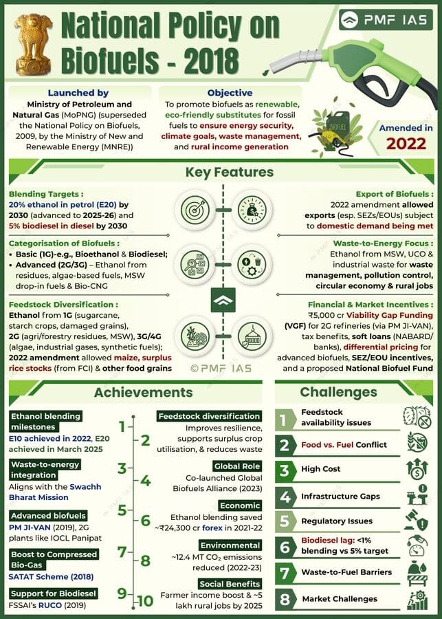
- According to the National Policy on Biofuels, 2018, the following materials can be used for biofuel production:
- For Ethanol Production:
- B-Molasses, Sugarcane juice, biomass in form of grasses, agriculture residues (Rice straw, cotton stalk, corn cobs, saw dust, bagasse etc.) , sugar containing materials like sugar beet, sweet sorghum, etc. and starch containing materials such as corn, cassava, rotten potatoes etc., Damaged food grains like wheat, broken rice etc. which are unfit for human consumption, Food grains during surplus phase. Algal feedstock and cultivation of sea weeds can also be a potential feedstock for ethanol production.
- For Biodiesel Production:
- Non- edible Oilseeds, Used Cooking Oil (UCO), Animal tallow, Acid Oil, Algal feedstock etc.
- For Advanced Biofuels:
- Biomass, MSW, Industrial waste, Plastic waste, etc
PMF Concept Hack
- Focus on the policy intent of National Policy on Biofuels — it encourages use of non-food, damaged, or surplus feedstock, not actively used food or oilseed crops. Thus, groundnut seeds and horse gram (Statements 3 and 4) can be eliminated as they are valuable food/oilseed crops and diverting them for biofuel is unlikely.
|
Answer: (a) 1, 2, 5 and 6 only; Difficulty Level: Easy
Which one of the following statements best describes the term ‘Social Cost of Carbon? It is a measure, in monetary value, of the
- Long-term damage done by a tonne of CO2 emissions in a given year.
- Requirement of fossil fuels for a country to provide goods and services to its citizens, based on the burning of those fuels.
- Efforts put in by a climate refugee to adapt to live in a new place.
- Contribution of an individual person to the carbon footprint on the planet Earth.
Explanation
Option (a) is correct
- The social cost of carbon (SCC) is an estimate, in dollars, of the economic damages that would result from emitting one additional ton of carbon dioxide into the atmosphere. The SCC puts the effects of climate change into economic terms to help policymakers and other decisionmakers understand the economic impacts of decisions that would increase or decrease emissions.
Answer: (a) Long-term damage done by a tonne of CO2 emissions in a given year; Difficulty Level: Easy
With reference to pulse production in India, consider the following statements:
- Black gram can be cultivated as both Kharif and rabi crops.
- Green-gram alone accounts for nearly half of pulse production.
- In the last three decades, while the production of kharif pulses has increased, the production of rabi pulses has decreased.
Which of the statements given above is/are correct?
- 1 only
- 2 and 3 only
- 2 only
- 1, 2 and 3 only
Explanation
Statement 1 is correct
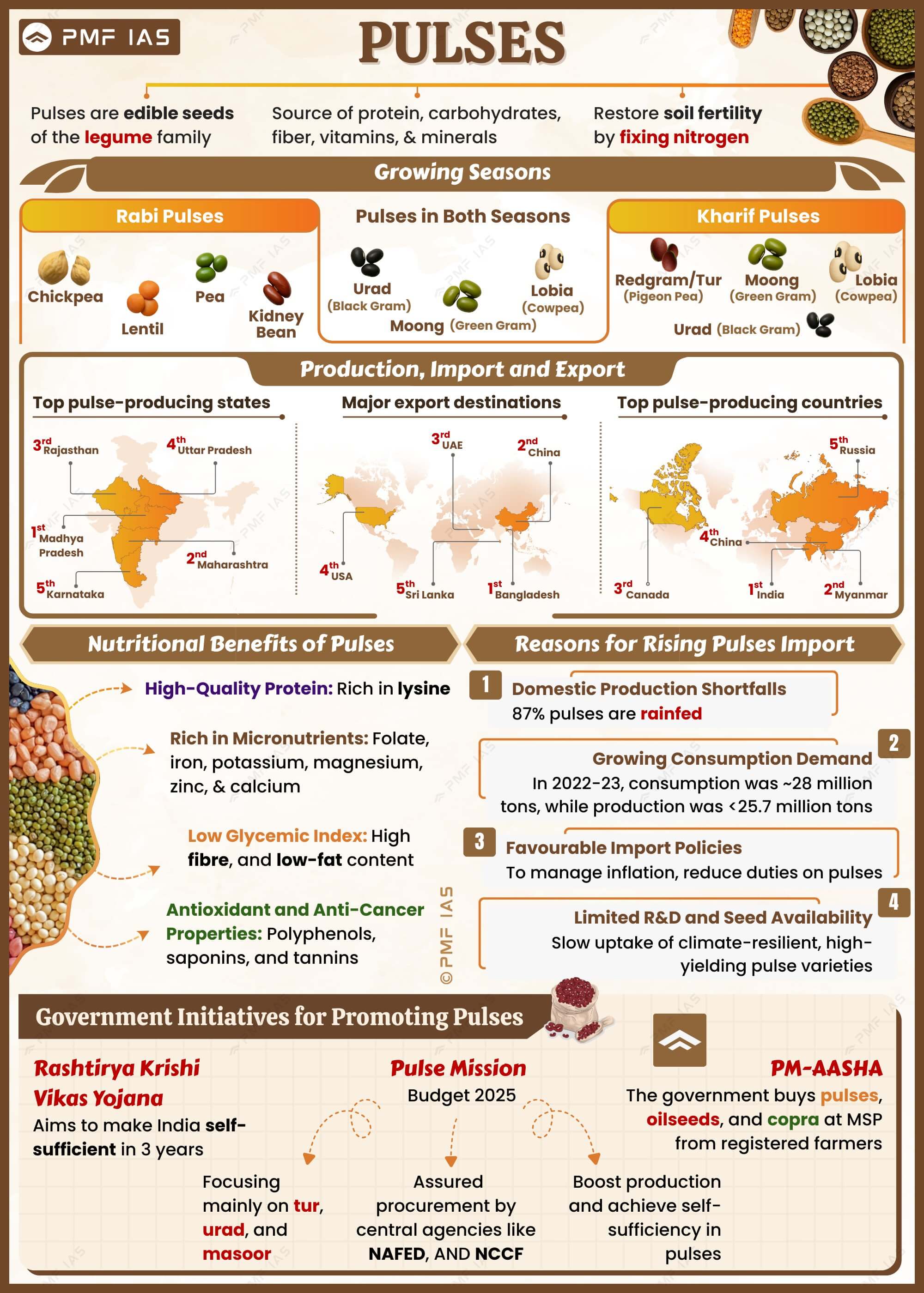
- Black gram (Vigna Mungo L.) is one of the important pulse crops, grown throughout the country.
- Kharif & Rabi Seasons: During kharif, it is cultivated throughout the country. It is best suited to rice fallows during rabi in the southern and south-eastern parts of India.
- It can be grown on a variety of soils ranging from sandy soils to heavy cotton soils. The ideal soil is a well-drained loam with a pH of 6.5 to 7.8. Black gram cannot be grown on alkaline and saline soils. The crop is resistant to adverse climatic conditions and improve the soil fertility by fixing atmospheric nitrogen in the soil. It is very rich in phosphoric acid.
- Global Production: India currently represents the largest producer of black gram, accounting for more than 70% of the global production. India is followed by Myanmar and Pakistan. Madhya Pradesh and Uttar Pradesh are major blackgram-growing states, area-wise.
Statement 2 is incorrect
- Greengram is an important pulse crop in India. It can be cultivated on wide range of soil. Gives the best result when grown on well-drained loamy to sandy-loam soils. It is a short-duration legume crop grown mostly as a fallow crop in rotation with rice. Similar to the leguminous pulses, greengram enriches soil nitrogen content. Saline and waterlogged soils are not suitable for cultivation. The fertiliser requirement is less, and it is disease-resistant.
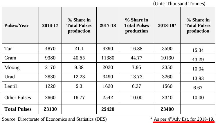
- According to the Directorate of Economics and Statistics (DES), the share of pulse production in 2018- 19 comprised Tur (15.34%), Gram (43.29%), Moong (green gram,10.04%), Urad (black gram, 13.93%), Lentil (6.67%), and Other Pulses (10%).
Statement 3 is incorrect
- According to a NITI Aayog report titled Demand and Supply Projections Towards 2033, production of kharif pulses was rising by 8.7 per cent in 1980 but fell to -6.6 per cent by 1990.
- Production of rabi pulses, too, was increasing at 5.5 per cent and fell to -3.2 per cent in 1990, but it then made a recovery in the next decade and grew at 4.2 per cent after 2000 due to programmes such as the Integrated Scheme of Oilseed, Pulses, Oil Palm and Maize and the National Food Security Mission.
Answer: (a) 1 only; Difficulty Level: Hard
“The crop is subtropical in nature. A hard frost is injurious to it. It requires at least 210 frost – free days and 50 to 100 centimetres of rainfall for its growth. A light, well-drained soil capable of retaining moisture is ideally suited for the cultivation of the crop.” Which one of the following is that crop?
- Cotton
- Jute
- Sugarcane
- Tea
Explanation
Option (a) is correct
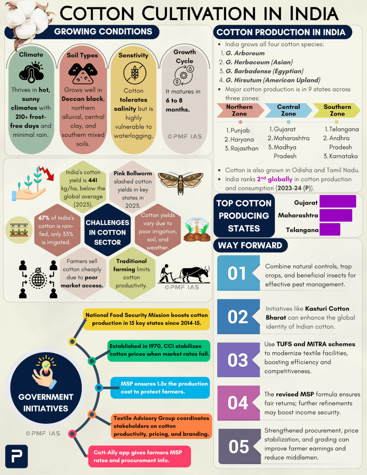
- Cotton crop thrives in hot, sunny climates with long frost-free periods (210 days) and requires high temperatures, light rainfall or irrigation, and bright sunshine.
- Soil: It grows well in the Deccan plateau’s black cotton soil, deep alluvial soils in northern India, black clayey soils in central regions, and mixed black and red soils in the southern zone.
- While cotton can tolerate some salinity, it is highly vulnerable to waterlogging. As a Kharif crop, cotton requires 6 to 8 months to mature. Adequate water needs can be fulfilled with an annual rainfall of 50-100 cm, but successful cultivation is also achievable in regions with lower rainfall through the use of irrigation.
Option (b) is incorrect
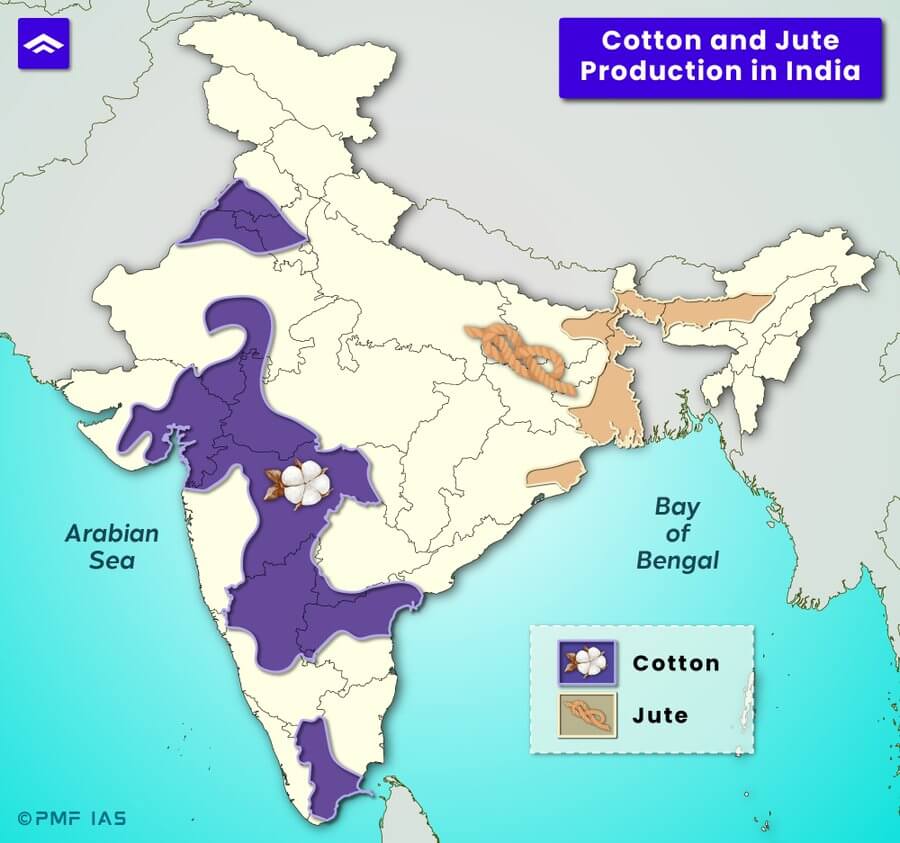
- Jute is the second most important fibre crop of India after cotton. It is a rain-fed crop with little need for fertiliser or pesticides. This is in contrast to cotton’s heavy fertiliser and pesticide requirements.
- Climate: Hot (24 °C to 35 °C) and humid climate (minimum rainfall of 120 cm/year) with 80 per cent relative humidity.
- Soil: Highly fertile alluvial soil (light sandy or clayey soils).
- Plenty of standing water is required for the growth and processing of the jute crop.
- Cropping season:
- Sowing and raising of saplings are carried out in the pre-monsoon season so as to take full advantage of the monsoon season.
- Jute is generally sown in February and harvested in October (crop takes 8-10 months to mature).
- The plants are usually harvested (stalks are cut off close to the ground) before the flowers turn into seeds.
- India is the world’s largest producer of jute. Bangladesh is the second largest with around 25% of the world’s jute production. Over 99 per cent of India’s total jute is produced in just five states: West Bengal, Bihar, Assam (Brahmaputra & Surma valleys), Andhra Pradesh, and Odisha.
Option (c) is incorrect
- Sugarcane has the largest value of production among all the commercial crops in India. It is indigenous to India. It belongs to the bamboo family.
- Climate: Sugarcane is predominantly a tropical crop. Requires a hot (21°-27°C) and humid (75-150 cm) climate. It requires 10 to 18 months to mature, depending on the geographical conditions. Too heavy rainfall results in low sugar content & deficiency in rainfall produces a fibrous crop. Temperature above 20°C combined with open sky in the second half of the crop season helps in acquiring juice and its thickening. A short, cool, dry winter season during ripening and harvesting is ideal.
- Frost is detrimental to sugarcane. It must be harvested before the frost season in the northern parts, where frost is a common phenomenon. On the other hand, hot, dry winds like “Loo” are hostile to sugarcane. (Both frost and loo are absent in South India. So south is ideal). It can tolerate any soil that retains moisture. Sugarcane exhausts the soil’s fertility.
- Sugar beet (tuber crop) is the temperate alternative for sugarcane)
Option (d) is incorrect
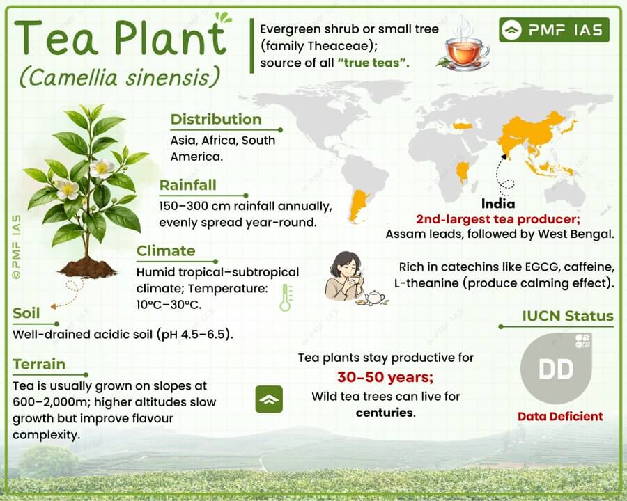
- Tea bush is indigenous to China. It was introduced in India by the British.
Answer: (a) Cotton; Difficulty Level: Medium
With reference to solar water pumps, consider the following statements:
- Solar power can be used for running surface pumps and not for submersible pumps.
- Solar power can be used for running centrifugal pumps and not the ones with piston.
Which of the statements given above is/are correct?
- 1 only
- 2 only
- Both 1 and 2
- Neither 1 nor 2
Explanation
Statement 1 is incorrect
- Solar power can be effectively used to run both surface pumps and submersible pumps. Surface pumps are used when water is close to the surface, such as in rivers or shallow wells. Submersible pumps, on the other hand, are designed to operate underwater, typically used in deeper wells.
- Solar-powered submersible pumps are widely used in agriculture and rural areas to access groundwater from deep sources. The solar panels provide the necessary electricity to power the pump, regardless of whether it is a surface or submersible type.
Statement 2 is incorrect
- Solar power can run both centrifugal and piston pumps. The choice between a centrifugal pump (which moves water by converting rotational kinetic energy) and a piston pump (which uses the back-and-forth motion of a piston to push water) depends on the specific water needs, such as volume and pressure
- Solar water pumps can be designed to accommodate different types of pumps, including those with pistons, depending on the user’s requirements. The source of power (solar energy) does not limit the type of pump that can be used.
Answer: (d) Neither 1 nor 2; Difficulty Level: Easy
With reference to the current trends in the cultivation of sugarcane in India, consider the following statements:
- A substantial saving in seed material is made when ‘bud chip settlings are raised in a nursery and transplanted in the main field.
- When direct planting of setts is done, the germination percentage is better with single-budded setts as compared to sets with many buds.
- If bad weather conditions prevail when setts are directly planted, single-budded setts have better survival as compared to large setts.
- Sugarcane can be cultivated using settlings prepared from tissue culture.
Which of the statements given above is/are correct?
- 1 and 2 only
- 3 only
- 1 and 4 only
- 2, 3 and 4 only
Explanation
Statement 1 is correct
- Chip bud technology is a highly promising approach for sugarcane production. This method involves excising sugarcane buds with a small portion of the root band, growing them in plant media, and transplanting the seedlings into the main field with precise row spacing. Using single-eyed seedlings significantly reduces seed requirements by 70%, needing only 1 ton per hectare, and allows leftover cane to be used for milling. This approach has been shown to increase cane yield by 11% compared to traditional methods and is considered a viable and economical alternative for reducing sugarcane production costs.
Statement 2 is incorrect
- The germination percentage is generally better with setts containing multiple buds rather than single-budded setts. Single-budded setts are more vulnerable to poor environmental conditions, which can reduce the overall germination rate compared to setts with multiple buds that offer better resilience.
Statement 3 is incorrect
- In adverse weather conditions, setts with multiple buds tend to survive better than single-budded setts.
- The presence of multiple buds increases the chances of at least one bud successfully germinating, providing more resilience compared to single-budded setts.
Statement 4 is correct
- Tissue culture is a method where plant fragments are cultured and grown in a laboratory setting. This technique enables the rapid production and supply of disease-free seed cane from existing commercial varieties. It involves cloning the mother plant using meristem tissue, which helps maintain the plant’s genetic identity. However, due to its complex process and physical constraints, tissue culture is proving to be economically unviable.
PMF Concept Hack
- Statement 2 can be eliminated first — logically, setts with many buds have better chances of germination than single-budded setts, making Statement 2 unlikely. Statement 3 is also incorrect because, under adverse weather conditions, larger setts with more buds and reserves generally have better survival than single-budded setts. After eliminating Statements 2 and 3, 1 and 4 remain correct — Answer: (c) 1 and 4 only.
|
Answer: (c) 1 and 4 only; Difficulty Level: Easy
In the context of India, which of the following is/are considered to be practice(s) of eco-friendly agriculture?
- Crop diversification
- Legume intensification
- Tensiometer use
- Vertical farming
Which of the statements given above is/are correct?
- 1, 2 and 3 only
- 3 only
- 4 only
- 1, 2, 3 and 4
Explanation
Crop diversification is correct
- It increases agricultural biodiversity (genetic, species and ecosystem), improves crop yields and produces quality to address both food and nutritional security. This practice also acts as a buffer against pests and diseases, as it can yield many agronomic benefits in pest management by breaking insect and disease cycles, reducing weeds and soil erosion, and conserving soil moisture. The more diverse a farming system is, with plants, animals, and soil-borne organisms, the more varied the population of beneficial, pest-fighting microbes in the soil.
Legume intensification is correct
- Legumes, such as pulses and beans, are known to fix atmospheric nitrogen into the soil, reducing the need for synthetic fertilizers. This practice improves soil fertility and promotes sustainable agricultural practices, contributing to eco-friendly farming.
Tensiometer use is correct
- A tensiometer measures soil moisture levels, helping farmers apply the right amount of irrigation. This practice reduces water wastage and promotes efficient water use, which is beneficial for eco-friendly agriculture
Vertical farming is incorrect
- In vertical farming, crops are grown indoors, under artificial conditions of light and temperature. It aims at higher productivity in smaller spaces. It uses soil-less methods such as hydroponics, aquaponics and aeroponics. Vertical Farming, while innovative and promising, is not as widely adopted in India compared to the other practices and is often associated with higher infrastructure costs (relies heavily on artificial inputs) and specific conditions not prevalent in all agricultural settings in India. It requires high energy consumption and specialised technology; therefore, it is not widely regarded as an eco-friendly practice.
Answer: (a) 1, 2 and 3 only; Difficulty Level: Easy
What are the advantages of fertigation in agriculture?
- Controlling the alkalinity of irrigation water is possible.
- Efficient application of Rock Phosphate and all other phosphatic fertilisers is possible.
- Increased availability of nutrients to plants is possible.
- Reduction in the leaching of chemical nutrients is possible.
Select the correct answer using the code given below:
- 1, 2 and 3 only
- 1, 2 and 4 only
- 1, 3 and 4 only
- 2, 3 and 4 only
Explanation
Statement 1 is correct
- Fertigation is a method of fertilizer application in which fertilizer is incorporated within the irrigation water by the drip system. In this system fertilizer solution is distributed evenly in irrigation. The availability of nutrients is very high, therefore the efficiency is higher. This method allows better control of irrigation water alkalinity by adjusting the fertiliser mix.
Statement 2 is incorrect
- While water-soluble phosphatic fertilisers such as urea are suitable for fertigation, rock phosphate is not, due to its insolubility.
Statement 3 is correct
- Fertigation enhances the efficiency of nutrient uptake by delivering nutrients directly to the plant roots in a readily available form, improving nutrient availability.
Statement 4 is correct
- Fertigation helps in reducing nutrient leaching because it delivers nutrients directly to the root zone in precise amounts, minimising runoff and wastage.
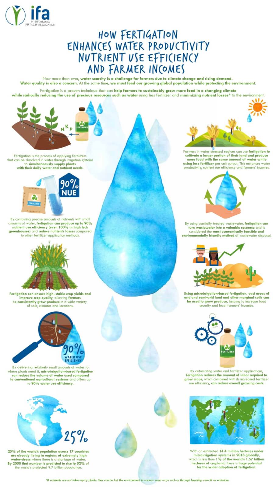
Image Source: Fertilizer.org
PMF Concept Hack
- Statement 2 can be eliminated because Rock Phosphate is not water-soluble, whereas fertigation generally requires water-soluble fertilizers. Moreover, the statement uses extreme wording by saying “all phosphatic fertilisers,” which is unlikely. Once Statement 2 is eliminated, only one option remains, making the correct answer easier to identify.
|
Answer: (c) 1, 3 and 4 only; Difficulty Level: Easy
Consider the following minerals:
- Bentonite
- Chromite
- Kyanite
- Sillimanite
In India, which of the above is/are officially designated as major minerals?
- 1 and 2 only
- 4 only
- 1 and 3 only
- 2, 3 and 4 only
Explanation
Bentonite is incorrect
- A mineral is a naturally occurring substance characterized by unique chemical and physical properties, composition, and atomic structure. In India, minerals are classified as major or minor under the Mines and Minerals (Development and Regulation) Amendment Act, 2015, to assess output value in the mining and quarrying sector.
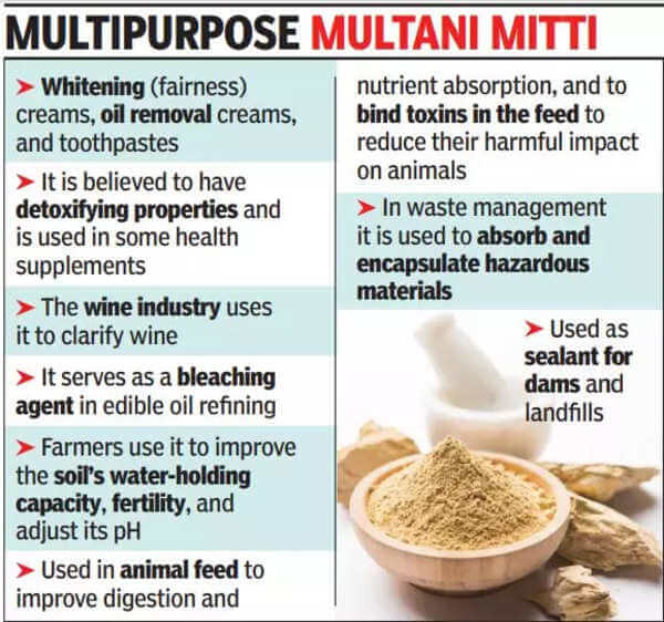
- As per Government of India official notification released in 2015 Bentonite (locally known as multani mitti or Fuller’s earth) has been declared as ‘Minor Mineral’.
Chromite is correct
- Chromite is a major mineral. It is a dark grey, metallic, oxide mineral often mistaken for magnetite due to its metallic lustre and occasional magnetic properties. It can be found in basic igneous rocks, as well as in metamorphic and sedimentary rocks created by weather-affected chromite-containing rocks. It is a crucial metal used to make hard, tough, and chemically resistant steel. The chromium extracted from chromite is used in chrome plating and alloying to produce corrosion-resistant superalloys, nichrome, and stainless steel. More than 96% of chromite resources are located in Odisha (Jajpur, Kendujhar, and Dhenkanal).
Kyanite is correct
- Kyanite is a major mineral. It occurs in metamorphic aluminous rocks. It has high-temperature resilience.
- Its quality relies on aluminium content: more aluminium, higher grade. It is primarily used in metallurgical, ceramic, glass, and cement industries. It is also used to make spark plugs in automobiles. Jharkhand, Maharashtra, and Karnataka produce nearly all of India’s kyanite. Jharkhand’s Singhbhum district leads in kyanite production (4/5th), followed by Maharashtra and Karnataka.
Sillimanite is correct
- Sillimanite is a major mineral. It is mainly composed of aluminium, silicon, and oxygen. It is commonly found in metamorphic rocks like schists, gneisses, and granulites. It is utilised in ceramics, glass, and metal production for its high melting point and thermal stability. It is ideal for lining kilns, furnaces, and high-temperature industrial processes due to its heat resistance, chemical inertness, and low electrical conductivity. It is valued as a gemstone but is relatively rare and not widely commercially available.
- Orissa is India’s largest producer of sillimanite, with Ganjam district contributing significantly.
Answer: (d) 2, 3 and 4 only; Difficulty Level: Hard
With reference to Ocean Mean Temperature (OMT), which of the following statements is/are correct?
- OMT is measured upto a depth of 26 degree Celsius isotherm which is 129 metres in the south- western Indian Ocean during January-March.
- OMT collected during January-March can be used in assessing whether the amount of rainfall in monsoon will be less or more than a certain long-term mean.
Select the correct answer using the code given below:
- 1 only
- 2 only
- Both 1 and 2
- Neither 1 nor 2
Explanation
- Ocean Mean Temperature (OMT) is an important parameter in oceanography and climate science, reflecting the average temperature of the ocean to a certain depth. It provides critical insights into climatic events like monsoon patterns.
Statement 1 is incorrect
- Sea Surface Temperature (SST), which is confined to the top few millimetres of the ocean and is heavily influenced by factors like strong winds, evaporation, and thick clouds, OMT is measured down to the depth of the 26-degree Celsius isotherm. This depth provides a more stable and consistent measure of ocean temperature, with less spatial variability. The 26-degree Celsius isotherm is typically found at depths ranging from 50 to 100 meters. In the Southwestern Indian Ocean during January to March, the average depth of the 26-degree Celsius isotherm is 59 meters.
Statement 2 is correct
- Sea surface temperature (SST) is routinely used for predicting whether the total amount of rainfall that India receives during the monsoon season will be less or more than the long-term mean of 887.5 mm.
- Scientists from Pune’s Indian Institute of Tropical Meteorology (IITM) find that ocean mean temperature (OMT) that has better ability to predict this than the sea surface temperature. Compared with SST which has 60% success rate of predicting the Indian summer monsoon, OMT has 80% success rate. In addition to better predictive success, the information on whether the amount of monsoon rainfall will be more or less than the long-term mean will be available by the beginning of April, two months before the southwest monsoon can set in. This is because OMT is analysed by measuring ocean thermal energy during January to March. The southwest monsoon sets in around June 1 each year in Kerala.
Answer: (b) 2 only; Difficulty Level: Hard
With reference to chemical fertilisers in India, consider the following statements:
- At present, the retail price of chemical fertilisers is market-driven and not administered by the Government.
- Ammonia, which is an input of urea, is produced from natural gas.
- Sulphur, which is a raw material for phosphoric acid fertiliser, is a by-product of oil refineries.
Which of the statements given above is/are correct?
- 1 only
- 2 and 3 only
- 2 only
- 1, 2 and 3
Explanation
Statement 1 is incorrect
- In India, the retail price of chemical fertilizers, especially urea, is regulated by the government under the Fertilizer Subsidy Scheme. The government sets maximum retail prices (MRP) for key fertilizers like urea and provides subsidies to manufacturers, allowing them to sell below market rates, ensuring affordability for farmers and boosting agricultural productivity.
Statement 2 is correct
- Ammonia is a vital industrial chemical, predominantly produced through Steam Methane Reforming (SMR) to generate hydrogen, followed by the Haber-Bosch process to synthesise the ammonia.
Statement 3 is correct
- Sulphur is a by-product produced in various refineries processing high-sulphur crude oil. Sulphur is produced from the sulphur-rich fuel gas as a process to reduce the emission level of sulphur in the atmosphere along with flue gases from the furnaces. It has been a key raw material for the fertiliser and chemical industries. It is the primary source for sulphuric acid, the world’s most widely used chemical, in a host of manufacturing processes. Sulphuric acid is used by the fertiliser industry to manufacture primarily phosphates and phosphoric acid, as well as other fertilisers such as ammonium sulphate.
Answer: (b) 2 and 3 only; Difficulty Level: Hard
With reference to India’s Desert National Park, which of the following statements are correct?
- It is spread over two districts.
- There is no human habitation inside the Park.
- It is one of the natural habitats of the Great Indian Bustard.
Select the correct answer using the code given below:
- 1 and 2 only
- 2 and 3 only
- 1 and 3 only
- 1, 2 and 3
Explanation
Statement 1 is correct
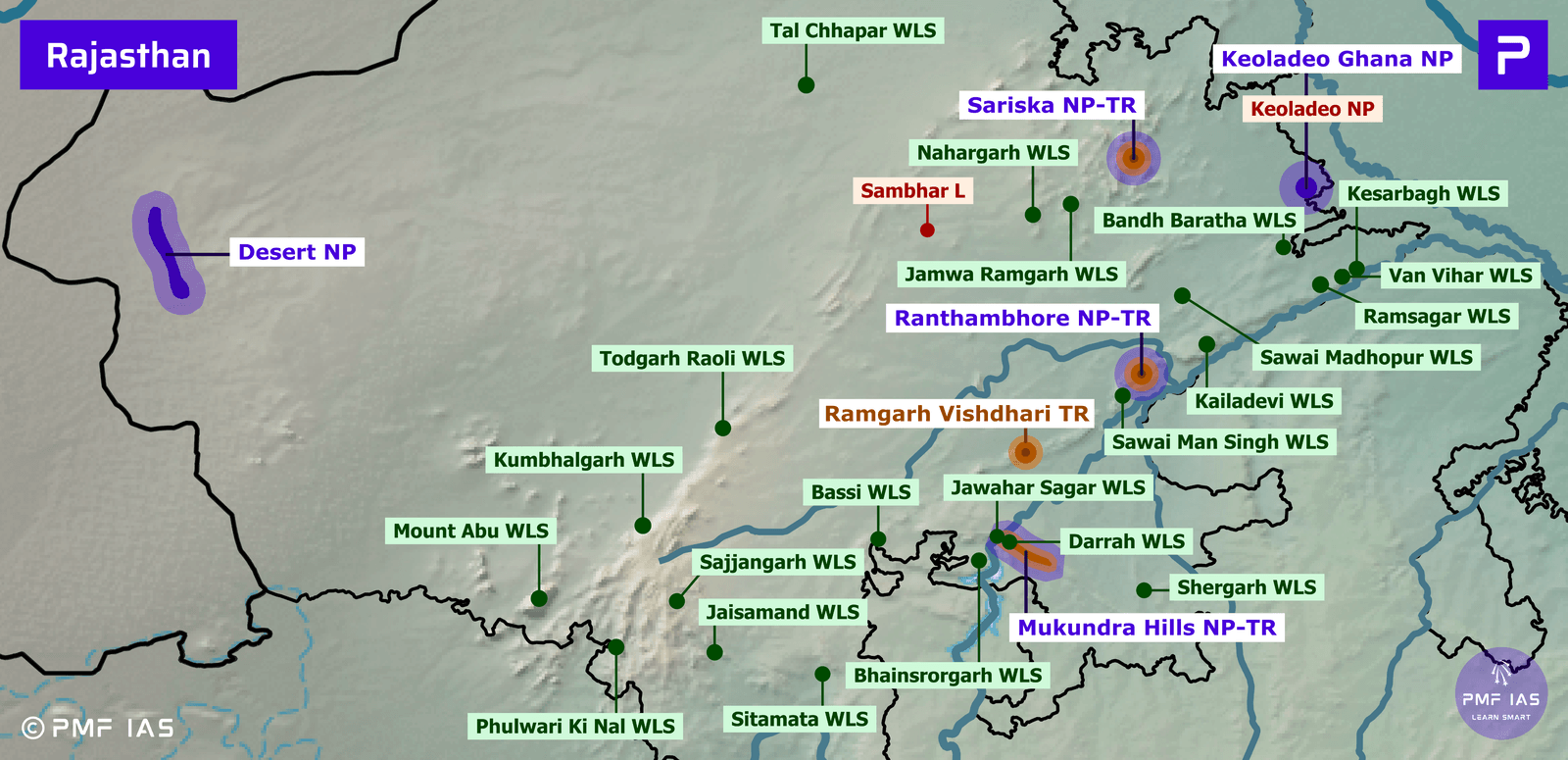
- Desert National Park: It is situated in the Jaisalmer and Barmer districts of Rajasthan.
- Vegetation: Open grassland, thorny bushes, and dunes.
- Major Flora: Patches of sewan grass and aak shrub.
Statement 3 is correct
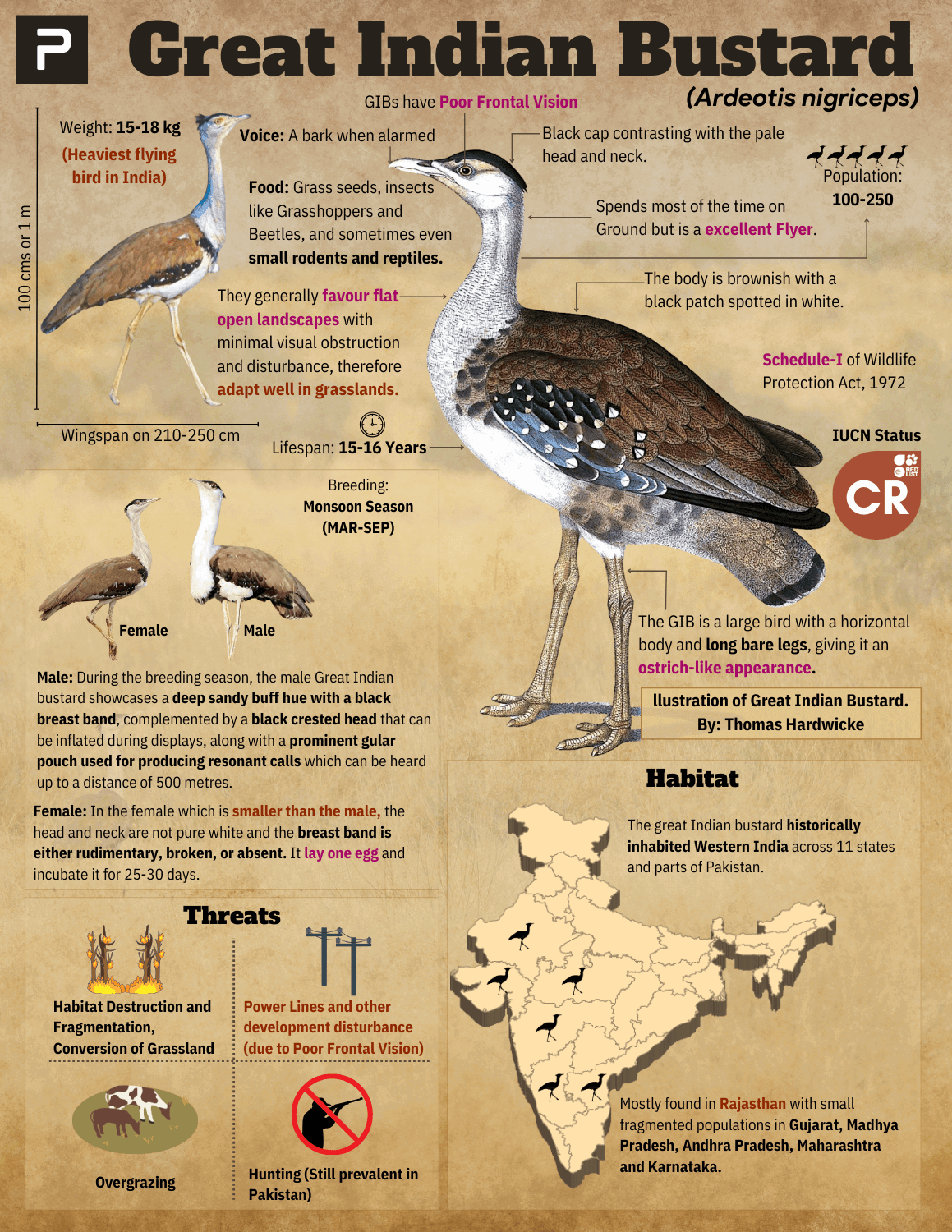
- Major Avifauna: Great Indian bustard (CR), eagles, harriers, falcons, buzzards, and vultures.
- Major Fauna: Chinkara or Indian Gazelle, desert fox.
Statement 2 is incorrect
- The area falls in the extreme hot and arid region of a very low rainfall zone (<100mm) of the country.
- Usually, no human settlements are allowed in a National Park. But there are some exceptions.
- The human population within the DNP is low (4-5 persons per km²). There are 73 villages and settlements or Dhanis existing within the Park. These communities have inhabited this area for hundreds of years and with their rich culture and tradition they are an integral part of this ecosystem.
Answer: (c) 1 and 3 only; Difficulty Level: Medium
Siachen Glacier is situated to the
- East of Aksai Chin
- East of Leh
- North of Gilgit
- North of Nubra Valley
Explanation
Option (d) is correct
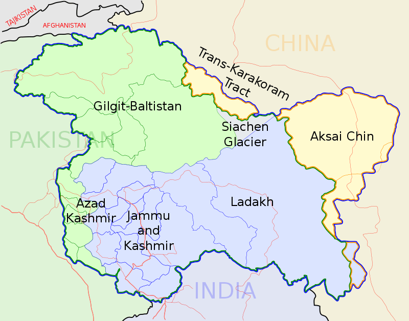
- It is located in the eastern Karakoram range in the Himalayas Mountains, just northeast of the point NJ9842, where the Line of Control between India and Pakistan ends. It forms part of the Union Territory of Ladakh.
- It is 76 km long, and its width varies between 2 km and 8 km, and it extends up to Gilgit-Baltistan. The glacier hangs at the snout towards OP Baba Shrine (a multifaith temple named after Om Prakash, an artillery soldier) and Indira Col (called by the Workman expedition after goddess Laxmi) at the northernmost point of the Saltoro Ridge.
- It is the Second-Longest glacier in the Non-Polar areas after the Fedchenko Glacier in Tajikistan. The Siachen Glacier lies immediately south of the great drainage divide that separates the Eurasian Plate from the Indian subcontinent in the extensively glaciated portion of the Karakoram, sometimes called the “Third Pole“. Nubra River originates from Siachen Glacier.
Answer: (d) North of Nubra Valley; Difficulty Level: Easy
With references to the history of India, consider the following pairs:
| Famous Place |
Present State |
| 1. Bhilsa |
Madhya Pradesh |
| 2. Dwarasamudra |
Maharashtra |
| 3. Girinagar |
Gujarat |
| 4. Sthanesvara |
Uttar Pradesh |
Which of the pairs given above are correctly matched?
- 1 and 3 only
- 1 and 4 only
- 2 and 3 only
- 2 and 4 only
Explanation
Pair 1 is correct
- Vidisha is an important historical city in the state of Madhya Pradesh. During the medieval period, it was known as Bhelsa (later Bhilsa). Situated at the confluence of the Betwa and Bes Rivers, and about 10 km from Sanchi, Vidisha occupied an important place among the ancient cities of India. In the 6th and 5th centuries BCE, it emerged as a major trade centre and flourished under the rule of the Shunga dynasty, Naga dynasty, Satavahana dynasty and Gupta Empire. Ashoka served as the governor of Vidisha, and the city also finds mention in Kalidasa’s immortal work Meghaduta. Until 1956, the city was known as Bhilsa, after which it was renamed Vidisha due to its proximity to the ancient city of great antiquity.
Pair 2 is incorrect
- Dwārasamudra, also known as Halebidu, is a historic town in the Hassan district of Karnataka. It served as the regal capital of the Hoysala Empire in the 12th century and is renowned for its exquisite Hoysala architecture, particularly the Hoysaleswara Temple. The term “Dwārasamudra” translates to “Gateway to the Ocean” in Sanskrit, reflecting its historical significance as a prominent capital during Hoysala rule.
Pair 3 is correct
- Girnar, also known as Girinagar or Revatak Parvata, is a group of mountains in the Junagadh District of Gujarat. It is an important pilgrimage site for both Hindus and Jains. Girnar is one of the five major ‘tirthas’ attributed to the ‘panch kalyanakas’ of various ‘Jain tirthankaras’.
Pair 4 is incorrect
- Thanesar (sometimes called Thaneswar and, archaically, Sthanishvara) is a historic town and an important Hindu pilgrimage centre on the banks of the Ghaggar River in the state of Haryana.
Answer: (a) 1 and 3 only; Difficulty Level: Medium
Consider the following statements:
- 36% of India’s districts are classified as “overexploited” or “critical” by the Central Ground Water Authority (CGWA).
- CGWA was formed under the Environment (Protection) Act.
- India has the largest area under groundwater irrigation in the world.
Which of the statements given above is/are correct?
- 1 only
- 2 and 3 only
- 2 only
- 1 and 3 only
Explanation
Statement 1 is incorrect
- To regulate the groundwater extraction, Government has divided areas with declining water tables mainly in three categories:
- Overexploited – Areas in which groundwater extraction rate is more than the groundwater recharge rate
- Critical – Areas where groundwater extraction rate is 90-100% of the recharge
- Semi-critical – Areas with an extraction rate of 70-100% of groundwater recharge
- The government data shows groundwater level in 16% of the taluka, mandal, block-level units in the country fall under the “over-exploited” category, while 4% fall under the “critical” category.
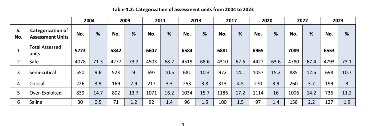
Image Source: CGWA
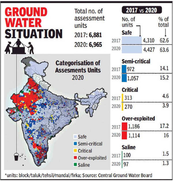
Image Source: TOI
Statement 2 is correct
- Central Ground Water Authority (CGWA):
- CGWA was constituted in January 1997 under sub-section (3) of Section 3 of the Environment Protection Act, 1986. It is responsible for the regulation and control of groundwater development and management at the central level.
- Powers & Functions:
- Exercise of powers under section 5 of the Environment (Protection) Act, 1986 for issuing directions and taking such measures in respect of all the matters referred to in sub-section(2) of section 3 of the said Act.
- To resort to penal provisions contained in sections 15 to 21 of the said Act.
- To regulate and control, management and development of ground water in the country and to issue necessary regulatory directions for the purpose.
- Exercise of powers under section 4 of the Environment (Protection) Act, 1986 for the appointment of officers.
Statement 3 is correct
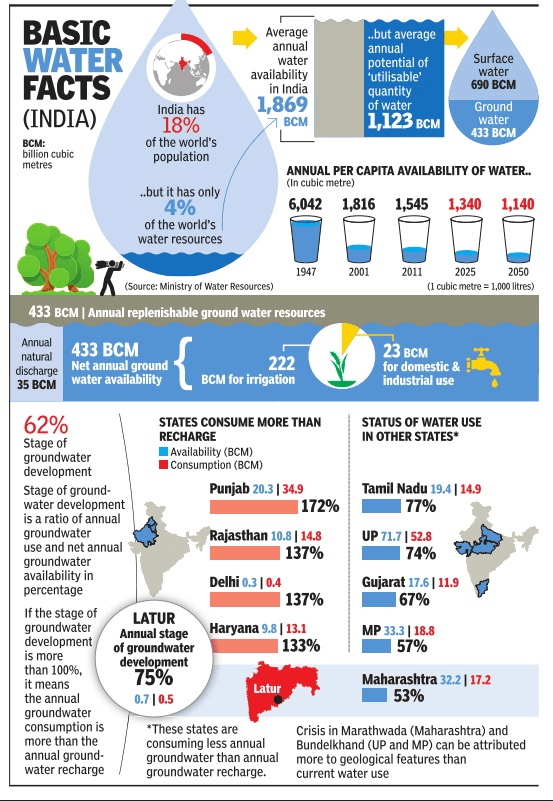
- India is the largest user of groundwater in the world. It uses an estimated 230 cubic kilometres of groundwater per year, over a quarter of the global total. More than 60% of irrigated agriculture and 85% of drinking water supplies are dependent on groundwater.
Answer: (b) 2 and 3 only; Difficulty Level: Hard
Consider the following statements:
- Jet Streams occur in the Northern Hemisphere only.
- Only some cyclones develop an eye.
- The temperature inside the eye of a cyclone is nearly 10 degree Celsius lesser than that of the surroundings.
Which of the statements given above is/are correct?
- 1 only
- 2 and 3 only
- 2 only
- 1 and 3 only
Explanation
Statement 1 is incorrect
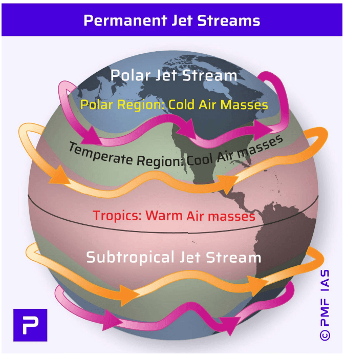
- Jet streams occur in both the Northern and Southern Hemispheres.
Statement 2 is correct
- The center of a tropical cyclone is called the eye, where winds are calm and there is typically no rainfall. In contrast, in a temperate cyclone (or extratropical cyclone), there is no single region where winds and precipitation are completely inactive.
Statement 3 is incorrect
- Along the eye, the air is slowly sinking and is heated due to compressional warming (adiabatic). The eye temperature may be 10°C warmer or more at an altitude of 12 km than the surrounding environment, but only 0-2°C warmer at the surface in the tropical cyclone.
- Eyes range in size from 8 km to over 200 km across, but most are approximately 30-60 km in diameter
Answer: (b) 2 and 3 only; Difficulty Level: Medium
Among the following Tiger Reserves, which one has the largest area under “Critical Tiger Habitat”?
- Corbett
- Ranthambore
- Nagarjunasagar-Srisailam
- Sunderbans
Explanation
Option (c) is correct
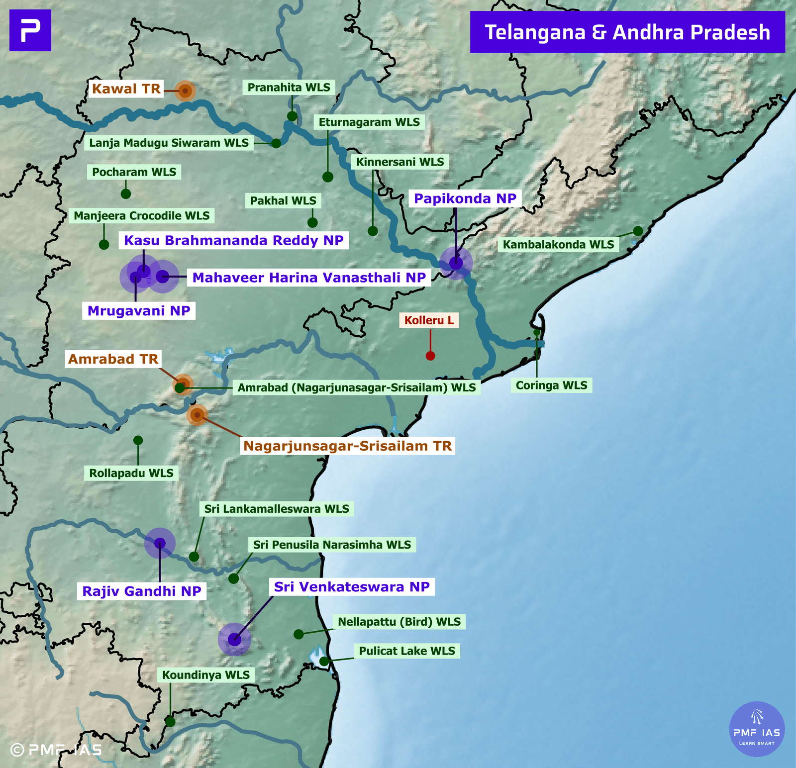
- Nagarjunsagar-Srisailam Tiger Reserve stands as the largest tiger reserve in India and possesses the most expansive core/critical tiger habitat within its boundaries. It spans the states of Andhra Pradesh and Telangana and lies in the Nallamala Hills. The Krishna River flows through the reserve, while both the Srisailam Reservoir and Nagarjunasagar Reservoir lie within its boundaries.
- Vegetation: tropical dry mixed deciduous forest.
- Major Fauna: Bengal tiger (EN), leopard, Indian pangolin (EN), spotted deer (chital) (LC), sambar (VU), blackbuck, chinkara, four-horned antelope (chausingha) (VU), mugger (marsh crocodile) (VU), etc.
Option (a) is incorrect
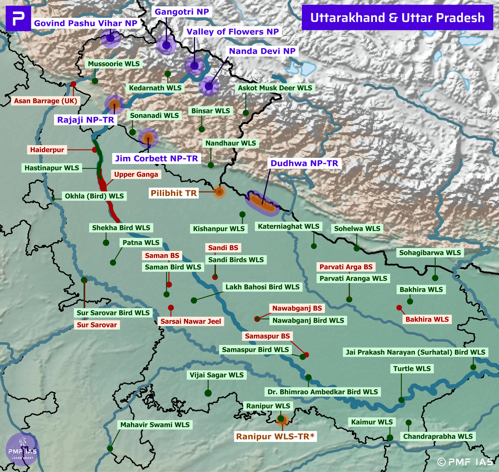
- Jim Corbett National Park, Corbett Tiger Reserve, is the oldest National Park in India and is located in Nainital. In 1936, it was established to protect the Bengal tiger. It was named after Jim Corbett, a well-known hunter and naturalist. The park was the first National Park to come under the Project Tiger initiative. Corbett Tiger Reserve’s core area is formed by Jim Corbett National Park, while the buffer contains Sonanadi Wildlife Sanctuary. Ramganga, Sonanadi and Kosi are the major rivers flowing through the National Park and Ramganga Reservoir is located within the National Park.
- Vegetation: Dense, moist deciduous forests, marshy depressions and grasslands.
- Major Fauna: Bengal tigers, elephants, leopards, Himalayan black bears, Himalayan goral, rhesus macaque.
- Local crocodiles and gharials were saved from extinction by captive breeding programs that subsequently released crocodiles into the Ramganga River.
- Threats: Invasive weeds and poaching.
- Corbett National Park is one of the thirteen protected areas covered by the World Wildlife Fund for Nature under their Terai Arc Landscape Program.
Option (b) is incorrect
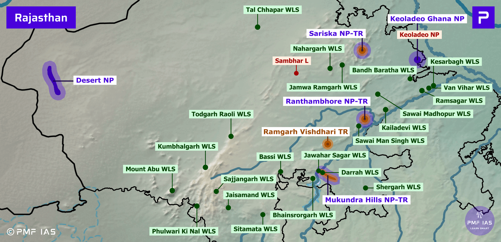
- Ranthambhore National Park, Tiger Reserve is bounded to the north by the Banas River and to the south by the Chambal River. According to experts, there is overcrowding at the Ranthambore reserve. The Rajasthan government has announced plans to develop the Bundi Wildlife Sanctuary as a Tiger Reserve, providing a second habitat for tigers alongside the Ranthambore Tiger Reserve.
- Vegetation: Dry deciduous forests and grasslands.
- Major Fauna: Bengal Tiger, leopard, nilgai, sambar.
- Major Reptilian Fauna: Mugger crocodile.
- Threats: Poaching, poisoning of tigers by villagers, habitat fragmentation.
Option (d) is incorrect
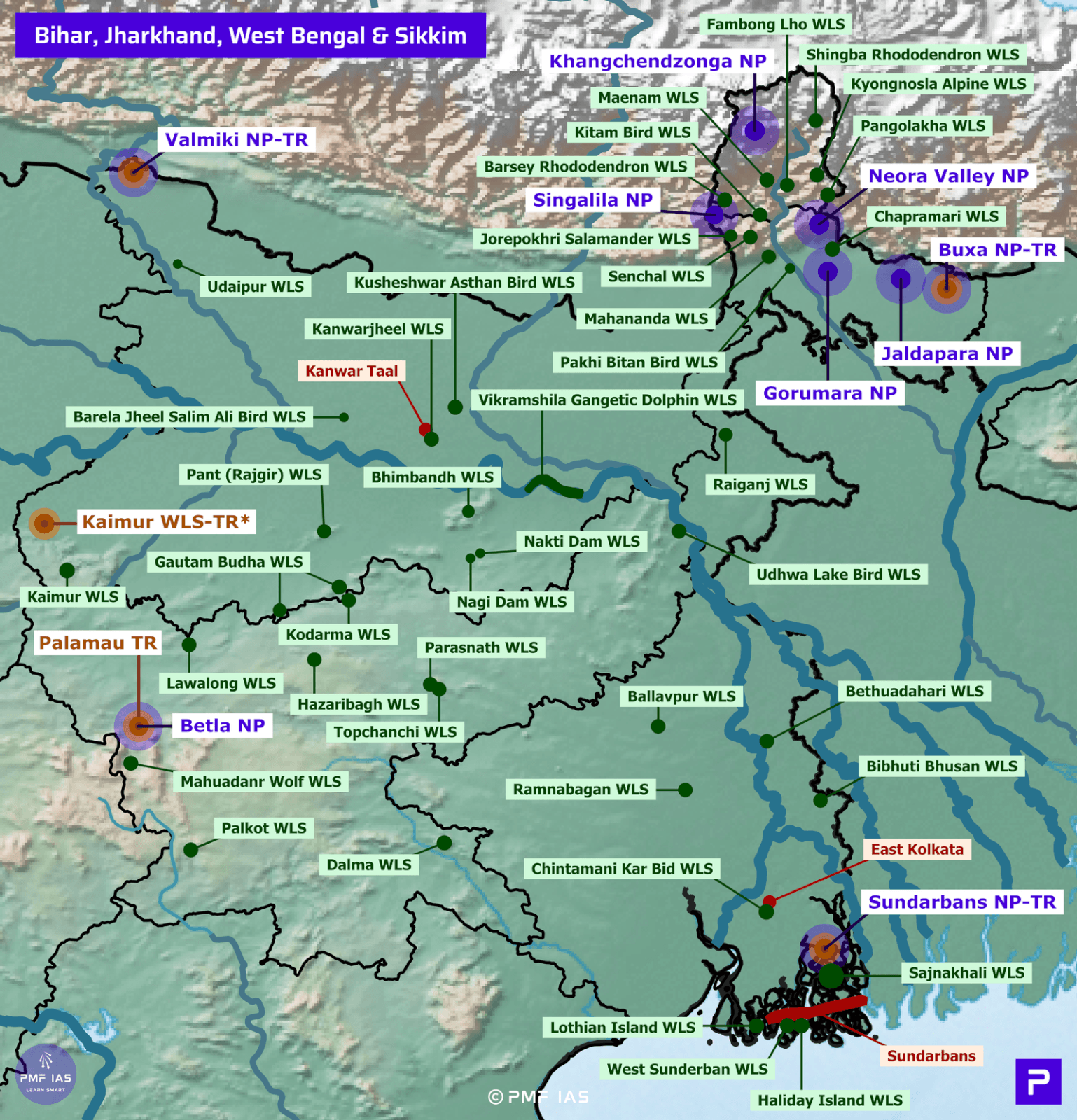
- Sunderban Biosphere Reserve, National Park, Tiger Reserve is the largest delta and mangrove forest in the world. Sundarbans National Park is a part of the Sundarbans on the Ganges Delta and is adjacent to the Sundarban Reserve Forest in Bangladesh. It is bound on the west by river Muriganga and on the east by rivers Harinbhahga and Raimangal. It is also a BR, a Tiger Reserve, a Ramsar Site, and a UNESCO World Heritage Site. The eco-geography of this area is dependent on the tidal effect. The tidal action deposits silts back on the channels, raising the bed and forming new islands and creeks.
- Vegetation: Mangrove forests (Sundarbans has achieved its name from the Sundari mangrove tree).
- Major Fauna: Royal Bengal Tiger, saltwater crocodile, river terrapin, olive ridley turtle, Ganges River dolphin, hawksbill turtle, mangrove horseshoe crab.
Additional Information
- Critical ‘tiger’ habitats (CTHs), also known as core areas of tiger reserves, are identified under the Wild Life Protection Act (WLPA) based on scientific evidence that “such areas are required to be kept as inviolate for the purpose of tiger conservation, without affecting the rights of the Scheduled Tribes or such other forest dwellers”. The notification of CTH is done by the state government in consultation with the expert committee constituted for the purpose. ‘Inviolate’ is a general term used to indicate no human settlement or usage. This inevitably implies that designating CTHs as inviolate areas requires relocating people living in them.
|
Answer: (c) Nagarjunasagar – Srisailam; Difficulty Level: Medium