
Comparison of Tropical Cyclones & Temperate Cyclones
Subscribe to Never Miss an Important Update! Assured Discounts on New Products!
Must Join PMF IAS Telegram Channel & PMF IAS History Telegram Channel
Tropical Cyclones and Temperate Cyclones -Comparison
Tropical Cyclone |
Temperate Cyclone |
|
Origin |
Thermal Origin | Dynamic Origin – Coriolis Force, Movement of air masses. |
Latitude |
Confined to 100 – 300 N and S of equator. | Confined to 350 – 650 N and S of equator. More pronounced in Northern hemisphere due to greater temperature contrast. |
Frontal system |
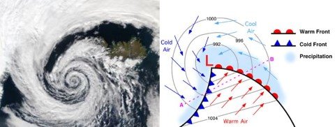
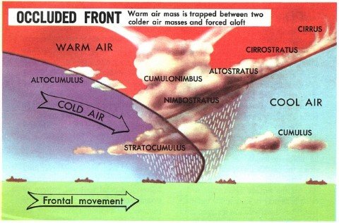
Absent | The very cyclone formation is due to frontogenesis.[Occluded Front] |
Formation |
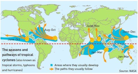
They form only on seas with temperature more than 26-270 C. They dissipate on reaching the land. | Can form both on land as well as seas |
Season |
Seasonal: Late summers (Aug – Oct) | Irregular. But few in summers and more in winters. |
Size |
Limited to small area.
Typical size: 100 – 500 kms in diameter. Varies with the strength of the cyclone. |
They cover a larger area.
Typical size: 300 – 2000 kms in diameter. Varies from region to region. |
Shape |
Elliptical
|
Inverted ‘V’
|
Rainfall |
Heavy but does not last beyond a few hours. If the cyclone stays at a place, the rainfall may continue for many days. | In a temperate cyclone, rainfall is slow and continues for many days, sometimes even weeks. |
Wind Velocity and destruction |
Much greater (100 – 250 kmph)(200 – 1200 kmph in upper troposphere)
Greater destruction due to winds, storm surges and torrential rains. |
Comparatively low. Typical range: 30 – 150 kmph.
Less destruction due to winds but more destruction due to flooding. |
Isobars |
Complete circles and the pressure gradient is steep | Isobars are usually ‘V’ shaped and the pressure gradient is low. |
Life time |
Doesn’t last for more than a week | Last for 2-3 weeks. |
Path |
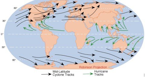
East – West. Turn North at 200 latitude and west at 300 latitude.
Move away from equator. The movement of Cyclones in Arabian Sea and Bay of Bengal is a little different. Here, these storms are superimposed upon the monsoon circulation of the summer months, and they move in northerly direction along with the monsoon currents.
|
West – East (Westerlies – Jet Streams). Move away from equator.
|
Temperature distribution |
The temperature at the center is almost equally distributed. | All the sectors of the cyclone have different temperatures |
Calm region |
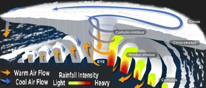
The center of a tropical cyclone is known as the eye. The wind is calm at the center with no rainfall. | In a temperate cyclone, there is not a single place where winds and rains are inactive.
|
Driving force |
The tropical cyclone derives its energy from the latent heat of condensation, and the difference in densities of the air masses does not contribute to the energy of the cyclone. | The energy of a temperate cyclone depends on the densities of air masses.
|
Influence of Jet streams |
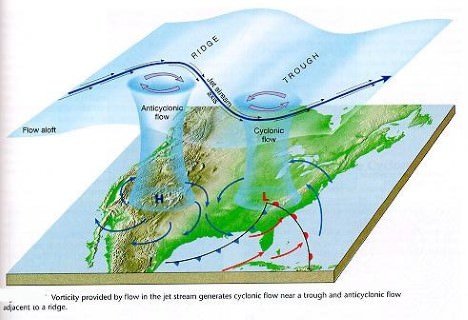
The relationship between tropical cyclones and the upper level air-flow is not very clear. | The temperate cyclones, in contrast, have a distinct relationship with upper level air flow (jet streams, Rossby waves etc.)
|
Clouds |
The tropical cyclones exhibit fewer varieties of clouds – cumulonimbus, nimbostratus, etc.. | The temperate cyclones show a variety of cloud development at various elevations.
|
Surface anti-cyclones |
The tropical cyclones are not associated with surface anticyclones and they have a greater destructive capacity. | The temperate cyclones are associated with anticyclones which precede and succeed a cyclone. These cyclones are not very destructive. |
Influence on India |
Both coasts effected. But east coast is the hot spot. | Bring rains to North – West India. The associated instability is called ‘Western Disturbances’. |
- Titbit: In certain instances, two cyclones move toward each other and revolve around one another, with the smaller and less intense one moving more quickly. This phenomenon is called the Fujlwara effect.
Primary References: NCERT Geography, IMD, Encyclopedia Britannica, Spectrum’s Geography [Amazon and Flipkart] and Savindra Singh [Amazon and Flipkart]






Dear sir
I have no words to explain about ur notes more than excellent well defined digram and note. One thing i want to say kindly prepare the agriculture geography notes also .
I will post Indian Agriculture notes in a week
Brilliant work!! No words to define.
Secure your content, else many people will copy-paste it.
Also start selling PDFs like other online websites do.
I do sell PDFs.
I have no problem with people copy pasting from my website. But those pathetic Piracy websites are the real problem. They make money out of somebody else’s hard work. Shame!
The favourite breeding grounds of temperate cyclones are:
1) Over USA and Canada, extending over Sierra Nevada, Colorado, Eastern Canadian
Rockies and the Great Lakes region.
2) Mexican Gulf
3) The belt extending from Iceland to Barents Sea and continuing over Russia and
Siberia.
4)Winter storms over Baltic Sea.
5) Mediterranean basin extending upto Russia and even upto India in winters (called
western disturbances)
6)The Antarctic frontal zone
NOT FOUND IN
1) South-east Caribbean region, May be it is quite near to the equator.
2) North-west Australia
May be here no occluded front forms as no airmass exits due to warm current.
Could you please explain why temperate cyclone doesnot form over these above two areas?
The prerequisite for the formation of Temperate cyclones is the convergence of a warm and cold air masses. Such a condition is met only between 30 degree and 60-70 degree N and S (that’s why they are called temperate cyclones). South-east Caribbean region and North-west Australia fall in tropics where there is no converging of warm and cold air masses (that’s why temperate cyclones are also called as extra-tropical cyclones).
Australia is between 15-38 degree N and Gulf of Mexico between 23 half and 30 degree N.So, in Gulf of Mexico as well there must be little chance of temperate cyclone .So,do they occur there or not?
Though GULF of Mexico’s Tropical cyclone are more frequent rather Temperate.
Just need some clarity on it.
You see the spatial distribution of temperate climate varies with seasons (in summer it shifts towards north and in winter it shifts south). For example in summer Gulf of Mexico will see tropical cyclones and in Winter they see Temperate cyclones. You can take Western disturbances that India face in winter as an example. The same western disturbances are almost non existent in summer as the temperate climate shifts north in summer.
Why the anticyclones do not intensify as tropical cyclones ?