
El Nino | ENSO | La Nina | El Nino Modoki | Indian Ocean Dipole (IOD)
Subscribe to Never Miss an Important Update! Assured Discounts on New Products!
Must Join PMF IAS Telegram Channel & PMF IAS History Telegram Channel
El Nino
- El Niño is the name given to the occasional development of warm ocean surface waters along the coast of Ecuador and Peru.
- When this warming occurs the usual upwelling of cold, nutrient rich deep ocean water is significantly reduced.
- El Niño normally occurs around Christmas and usually lasts for a few weeks to a few months.
- Sometimes an extremely warm event can develop that lasts for much longer time periods. In the 1990s, strong El Niños developed in 1991 and lasted until 1995, and from fall 1997 to spring 1998.
Normal Conditions
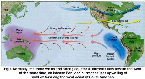
- In a normal year, a surface low pressure develops in the region of northern Australia and Indonesia and a high pressure system over the coast of Peru. As a result, the trade winds over the Pacific Ocean move strongly from east to west.
- The easterly flow of the trade winds carries warm surface waters westward, bringing convective storms (thunderstorms) to Indonesia and coastal Australia. Along the coast of Peru, cold bottom cold nutrient rich water wells up to the surface to replace the warm water that is pulled to the west.
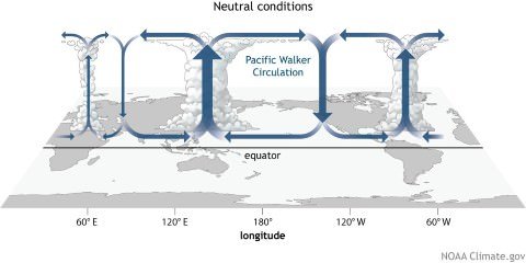
Walker circulation (Occurs during Normal Years)
- The Walker circulation (walker cell) is caused by the pressure gradient force that results from a high pressure system over the eastern Pacific ocean, and a low pressure system over Indonesia.
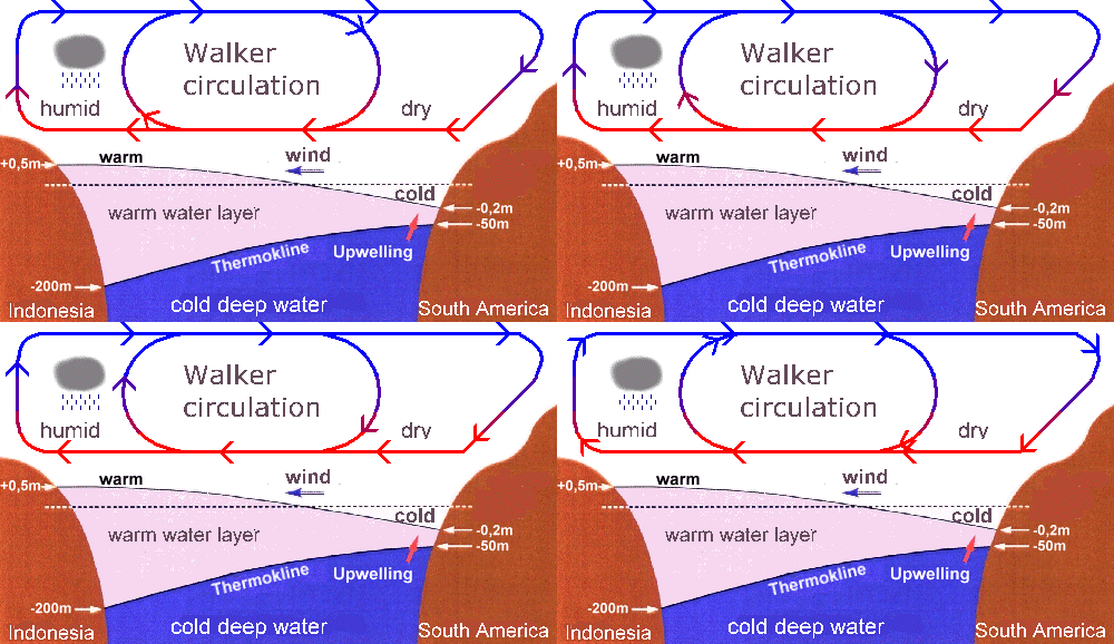
This cross-section of the Pacific Ocean, along the equator, illustrates the pattern of atmospheric circulation typically found at the equatorial Pacific. Note the position of the thermocline.
- Thermocline == noun a temperature gradient in a lake or other body of water, separating layers at different temperatures.
- The Walker cell is indirectly related to upwelling off the coasts of Peru and Ecuador. This brings nutrient-rich cold water to the surface, increasing fishing stocks.
During El Nino year
- In an El Niño year, air pressure drops over large areas of the central Pacific and along the coast of South America.
- The normal low pressure system is replaced by a weak high in the western Pacific (the southern oscillation). This change in pressure pattern causes the trade winds to be reduced == Weak Walker Cell. Sometimes Walker Cell might even get reversed.
- This reduction allows the equatorial counter current (current along doldrums) to accumulate warm ocean water along the coastlines of Peru and Ecuador.
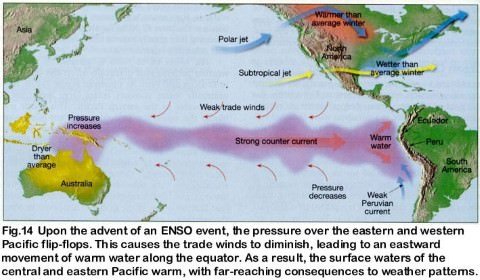
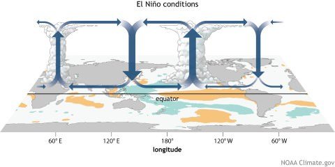
- This accumulation of warm water causes the thermocline to drop in the eastern part of Pacific Ocean which cuts off the upwelling of cold deep ocean water along the coast of Peru.
- Climatically, the development of an El Niño brings drought to the western Pacific, rains to the equatorial coast of South America, and convective storms and hurricanes to the central Pacific.
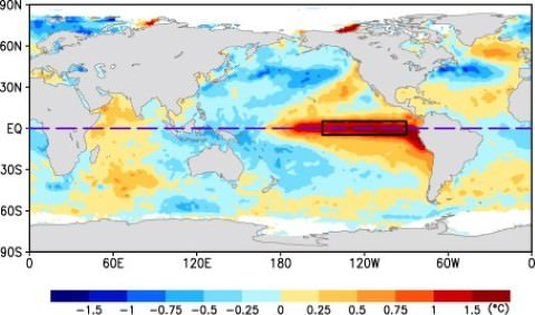
This cross-section of the Pacific Ocean, along the equator, illustrates the pattern of atmospheric circulation that causes the formation of the El Niño.
- In the image above, we can see the presence of a strong El Niño event (October, 1997).
Effects of El Nino
- The warmer waters had a devastating effect on marine life existing off the coast of Peru and Ecuador.
- Fish catches off the coast of South America were lower than in the normal year (Because there is no upwelling).
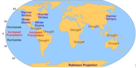
- Severe droughts occur in Australia, Indonesia, India and southern Africa.
- Heavy rains in California, Ecuador, and the Gulf of Mexico.
Normal Conditions
Eastern Pacific == Coast of Peru and Ecuador == Cold Ocean Water == Good for Fishing.
Western Pacific == Indonesia and Australia == Warm Ocean Water == Plenty of rains.
El Nino Condition
Eastern Pacific == Coast of Peru and Ecuador == Warm Ocean Water == Fishing industry takes a hit.
Western Pacific == Indonesia and Australia == Cold Ocean Water == Drought.
How El Nino impacts monsoon rainfall in India
- El Nino and Indian monsoon are inversely related.
- The most prominent droughts in India – six of them – since 1871 have been El Nino droughts, including the recent ones in 2002 and 2009
- However, not all El Nino years led to a drought in India. For instance, 1997/98 was a strong El Nino year but there was no drought (Because of IOD).
- On the other hand, a moderate El Nino in 2002 resulted in one of the worst droughts.
- El Nino directly impacts India’s agrarian economy as it tends to lower the production of summer crops such as rice, sugarcane, cotton and oilseeds.
- The ultimate impact is seen in the form of high inflation and low gross domestic product growth as agriculture contributes around 14 per cent to the Indian economy.
El Nino Southern Oscillation [ENSO]
- The formation of an El Niño [Circulation of Water] is linked with Pacific Ocean circulation pattern known as the southern oscillation [circulation of atmospheric pressure]
- Southern Oscillation, in oceanography and climatology, is a coherent inter-annual fluctuation of atmospheric pressure over the tropical Indo-Pacific region.
- El Nino and Southern Oscillation coincide most of the times hence their combination is called ENSO – El Nino Southern Oscillation.
Only El Nino == [Warm water in Eastern Pacific + Cold water in Western Pacific].
Only SO == [Low Pressure over Eastern Pacific + High Pressure over Western Pacific]
ENSO = [Warm water in Eastern Pacific + Low Pressure over Eastern Pacific] + [Cold water in Western Pacific + High Pressure over Western Pacific].
Southern Oscillation Index and Indian Monsoons
- SO is a see-saw pattern of meteorological changes observed between the Eastern Pacific and Western Pacific.
- When the pressure was high over equatorial Eastern Pacific, it was low over the equatorial Western Pacific and vice versa.
- The pattern of low and high pressures gives rise to vertical circulation along the equator with its rising limb over low pressure area and descending limb over high pressure area. This is known as Walker Circulation.
- The location of low pressure and hence the rising limb over Western Pacific is considered to be conductive to good monsoon rainfall in India.
- Its shifting eastward from its normal position, such as in El Nino years, reduces monsoon rainfall in India.
- Due to the close association between an El Nino (E.N.) and the Southern Oscillation SO the two are jointly referred to as an ENSO event.
- The periodicity of SO is not fixed and its period varies from two to five years.
- Southern Oscillation Index (SOD) is used to measure the intensity of the Southern Oscillation.
- This is the difference in pressure between Tahiti in French Polynesia (Central Pacific), representing the Central Pacific Ocean and Port Darwin, in northern Australia representing the Eastern Pacific Ocean.
- The positive and negative values of the SOI i.e. Tahiti minus the Port Darwin pressure are pointers towards good or bad rainfall in India.
Positive SOI |
Negative SOI |
| Tahiti pressure greater than that of Port Darwin | Reverse |
| Pressure high over eastern Pacific and low over | Reverse |
| Drought conditions in Eastern Pacific and good rainfall in Western Pacific (Northern Australia and Indonesia) | Reverse |
| Good for Indian Monsoons | Bad for Indian Monsoons |
Indian Ocean Dipole effect (Not every El Nino year is same in India)
- Although ENSO was statistically effective in explaining several past droughts in India, in the recent decades the ENSO-Monsoon relationship seemed to weaken in the Indian subcontinent. For e.g. the 1997, strong ENSO failed to cause drought in India.
- However, it was later discovered that just like ENSO was an event in the Pacific Ocean, a similar seesaw ocean-atmosphere system in the Indian Ocean was also at play. It was discovered in 1999 and named the Indian Ocean Dipole (IOD).
- The Indian Ocean Dipole (IOD) is defined by the difference in sea surface temperature between two areas (or poles, hence a dipole) – a western pole in the Arabian Sea (western Indian Ocean) and an eastern pole in the eastern Indian Ocean south of Indonesia.
- IOD develops in the equatorial region of Indian Ocean from April to May peaking in October.
- With a positive IOD winds over the Indian Ocean blow from east to west (from Bay of Bengal towards Arabian Sea). This results in the Arabian Sea (western Indian Ocean near African Coast) being much warmer and eastern Indian Ocean around Indonesia becoming colder and dry.
- In the negative dipole year (negative IOD), reverse happens making Indonesia much warmer and rainier.
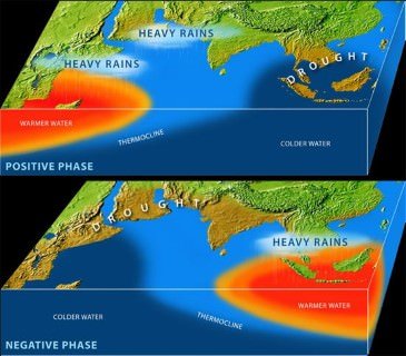
- It was demonstrated that a positive IOD index often negated the effect of ENSO, resulting in increased Monsoon rains in several ENSO years like the 1983, 1994 and 1997.
- Further, it was shown that the two poles of the IOD – the eastern pole (around Indonesia) and the western pole (off the African coast) were independently and cumulatively affecting the quantity of rains for the Monsoon in the Indian subcontinent.
- Similar to ENSO, the atmospheric component of the IOD was later discovered and named as Equatorial Indian Ocean Oscillation [EQUINOO][Oscillation of warm water and atmospheric pressure between Bay of Bengal and Arabian Sea].
Impact on IOD on Cyclonogeneis in Northern Indian Ocean
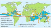
- Positive IOD (Arabian Sea warmer than Bay of Bengal) results in more cyclones than usual in Arabian Sea.
- Negative IOD results in stronger than usual cyclonogenesis (Formation of Tropical Cyclones) in Bay of Bengal. Cyclonogenesis in Arabian Sea is suppressed.
The El Niño Modoki
- El Niño Modoki is a coupled ocean-atmosphere phenomenon in the tropical Pacific.
- It is different from another coupled phenomenon in the tropical Pacific namely, El Niño.
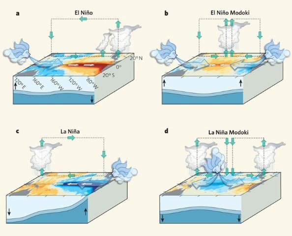
- Conventional El Niño is characterized by strong anomalous warming in the eastern equatorial Pacific.
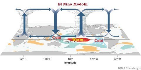
- Whereas, El Niño Modoki is associated with strong anomalous warming in the central tropical Pacific and cooling in the eastern and western tropical Pacific (see figure below).
El Niño Modoki Impacts
- The El Niño Modoki phenomenon is characterized by the anomalously warm central equatorial Pacific flanked by anomalously cool regions in both west and east.
- Such zonal gradients result in anomalous two-cell Walker Circulation over the tropical Pacific, with a wet region in the central Pacific.
La Nina
- After an El Niño event weather conditions usually return back to normal.
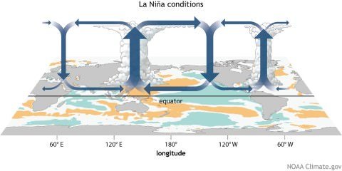
- However, in some years the trade winds can become extremely strong and an abnormal accumulation of cold water can occur in the central and eastern Pacific. This event is called a La Niña.
- A strong La Niña occurred in 1988 and scientists believe that it may have been responsible for the summer drought over central North America. During this period, the Atlantic Ocean has seen very active hurricane seasons in 1998 and 1999.
- One of the hurricanes that developed, named Mitch, was the strongest October hurricane ever to develop in about 100 years of record keeping.
Effects of La Nina
- Some of the other weather effects of La Niña include
- abnormally heavy monsoons in India and Southeast Asia,
- cool and wet winter weather in southeastern Africa, wet weather in eastern Australia,
- cold winter in western Canada and northwestern United States,
- winter drought in the southern United States.
Primary References: NCERT Geography, Spectrum’s Geography [Amazon and Flipkart], Kullar Indian Geography






sir,in impact of iod on cyclonogensis the neative iod is described as warmer arabian sea warme tha bay of bengal, shouldn’t it be positive iod ?
Corrected:
Positive IOD (Arabian Sea warmer than Bay of Bengal) results in more cyclones than usual in Arabian Sea.
Negative IOD results in stronger than usual cyclonogenesis (Formation of Tropical Cyclones) in Bay of Bengal. Cyclonogenesis in Arabian Sea is suppressed.
comprehensive one…
good job//
Sir I am a bit confused, your notes has mentioned Port Darwin as Eastern Pacific, but it lies west to pacific ocean, please correct me if I’m wrong.
Sir I am a bit confused, your notes has mentioned Port Darwin as Eastern Pacific, but it lies west to pacific ocean, please correct me if I’m wrong.
As earth revolves, if you look at the map of only Pacific then Peru is at the east point and Indonesia and Australia are in West relatively. Just look at Pacific not at all earth. Their relative position is considered here. I think it’s clear to you sir.
Thank you.
Port Darwin, in northern Australia representing the ***********************Eastern Pacific Ocean.***************
it ll be western i think.
Yeah it’s western specific
Eastern pacific is Peruvian coast
Port Darwin, in northern Australia representing the ***********************Eastern Pacific Ocean.***************
it ll be western i think.
Best explanation found!!!!!!! Just would like to know impact of el nino Modoki on Cyclogenesis in Arabian sea
will cause subsidence( draught like conditions) near Australia and Indonesia thus less cyclones in BoB but due to the presence of warmer water over Arabian sea more cyclones are produced
Very nicely explaine