• Home
  • Geography
    • Physical Geography
      • Geomorphology
      • Climatology
      • Climatic Regions
      • Oceanography
    • Indian Geography
    • Economic Geography
  • Environment
  • Science
  • Store
  • Newsletter
  • Ad Free
    • One Year Add Free Subscription @ just Rs. 49/- Know More

      Already subscribed? Login Here and Reload the Current Page.

      -------------- OR --------------

      Login with GoogleLogin with Facebook

      Manage Account. Questions? Contact us.

  • Books

PMF IAS

Notes for UPSC IAS Civil Services Exam

 GEO+ENVI @ 119  GEOGRAPHY-90  ENVIRONMENT-60  BIOLOGY-20 MAJOR CROPS-10 ART & CULTURE
PMF IAS > Geography > Geomorphology > Important mountain ranges: Himalayas | Andes | Rockies | Urals | Drakensberg
Visit Edutap.co.in

Important mountain ranges: Himalayas | Andes | Rockies | Urals | Drakensberg

Previous Post:Fold Mountains & Block Mountains (most important types of mountains)
Next Post:Divergent Boundary | African Rift System (The Great Rift)

December 21, 2015 by PMF IAS 2 Comments

Visit Edutap.co.in
Visit Edutap.co.in

Table of Contents

  • 1 Important mountain ranges
  • 2 Andes
  • 3 Rocky Mountains
  • 4 Great Dividing Range
  • 5 Transantarctic Mountains
  • 6 Ural Mountains
  • 7 Atlas Mountains
  • 8 Appalachian Mountains
  • 9 Himalayas
  • 10 Alps
  • 11 Mountain ranges By height
  • 12 Why are world’s highest mountains are at the equator?
  • 13 Highest mountain peaks of the world
  • 14 Highest peak of each continent
Share
WhatsApp
+1
Tweet
Email

In this post we will study about some of the most Important Mountain Ranges of the World.

To know about the formation of different mountains, follow these links

  • Continent – Ocean Convergence – Formation of Andes, Rockies
  • Continent – Continent Convergence: Formation of Himalayas

To know about types of mountains, follow these links

  • Types of Mountains – Classification of Mountains
  • Fold Mountains – Block Mountains

Important mountain ranges

  • The highest known mountain on any planet in the Solar System is Olympus Mons on Mars (~26 km in elevation). It is also the highest active volcano in the Solar System.
  1. Andes – 7,000 km
  2. Rocky Mountains – 4,830 km
  3. Great Dividing Range – 3,500 km
  4. Transantarctic Mountains – 3,500 km
  5. Ural Mountains – 2,500 km
  6. Atlas Mountains – 2,500 km
  7. Appalachian Mountains – 2,414 km
  8. Himalayas – 2,400 km
  9. Altai Mountains – 2,000 km (1,243 mi)
  10. Western Ghats – 1,600 km
  11. Alps – 1,200 km
  12. Drakensberg – 1,125 km
  13. Aravalli Range – 800 km

Mountains-in-the-world mountains in central asia - altai -kunlun-tien shan -pamirsdrakensberg mountains - south africa

Andes

  • The Andes is the longest continental mountain range in the world.
  • Formed due to Ocean-Continent collision.
  • Average height of about 4,000 m.
  • Spread along Venezuela, Colombia, Ecuador, Peru, Bolivia, Chile, and Argentina.
  • The Andes is the world’s highest mountain range outside of Asia.
  • The highest peak, Mount Aconcagua, rises to an elevation of about 6,962 m above sea level
  • World’s highest volcanoes are in the Andes. Ojos del Salado (6,893 m) on the Chile-Argentina border is the highest volcano on earth.
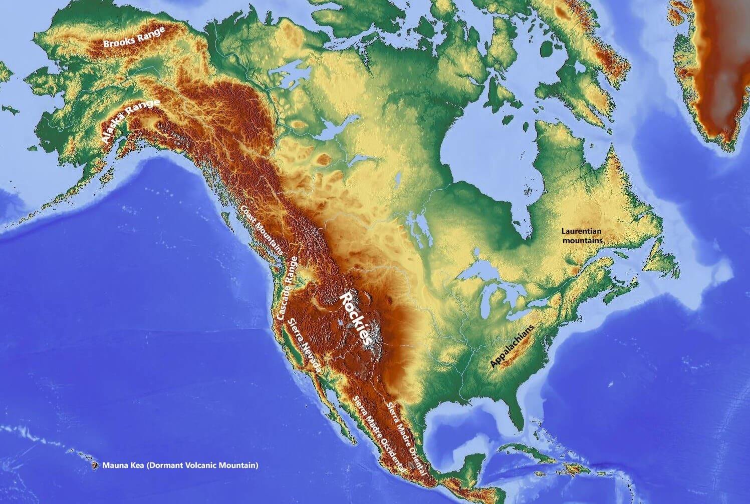
Andes mountains south americaAndes mountains south america

Geology

  • Caused by the subduction of oceanic crust beneath the South American plate.
  • Formed due to compression of western rim of the South American Plate due to the subduction of the Nazca Plate and the Antarctic Plate.

Rocky Mountains

  • Mountain range in western North America.
  • The Rocky Mountains stretch more than 3,000 miles.
  • Spread along northernmost part of British Columbia, in western Canada, to New Mexico, in the southwestern U.S.

Rocky Mountains

Geology of the Rocky Mountains

  • Formed due to Ocean – Continent collision.
  • The rocks making up the mountains were formed before the mountains were raised.
  • The Rocky Mountains took shape during an intense period of plate tectonic activity that resulted in much of the rugged landscape of the western North America.

Great Dividing Range

  • The Great Dividing Range, or the Eastern Highlands, is Australia’s most substantial mountain range and the third longest land-based range in the world.
  • It is also known as the Australian Alps.
  • I was formed due to rifting (divergent boundary).

australian alps-Great Dividing Range formation of Great Dividing Range - australian alps

Transantarctic Mountains

Transantarctic Mountains -antarctic

Ural Mountains

  • Mountain range that runs approximately from north to south through western Russia, from the coast of the Arctic Ocean to the Ural River and northwestern Kazakhstan.
  • Their eastern side is usually considered the natural boundary between Europe and Asia.
  • They are rich in various deposits, including metal ores, coal, precious and semi-precious stones.
  • Since the 18th century the mountains have been a major mineral base of Russia.

Ural Mountains - russia

Geology

  • The Urals are among the world’s oldest extant mountain ranges.
  • Formed due to Continent – Continent collision.
  • They were formed during the Uralian orogeny due to the collision of the eastern edge of the supercontinent Laurussia with the young and weak continent of Kazakhstania, which now underlies much of Kazakhstan. The collision lasted nearly 90 million years in the late Carboniferous – early Triassic.
  • Unlike the other major orogens of the Paleozoic (Appalachians, Caledonides), the Urals have not undergone post-orogenic extensional collapse and are unusually well preserved for their age. For its age of 250 to 300 million years, the elevation of the mountains is unusually high.

Atlas Mountains

  • Mountain range across the northwestern stretch of Africa extending about 2,500 km (1,600 mi) through Algeria, Morocco and Tunisia.
  • The highest peak is Toubkal, with an elevation of 4,165 metres (13,665 ft) in southwestern Morocco.
  • The Atlas ranges separate the Mediterranean and Atlantic coastlines from the Sahara Desert.
  • These mountains were formed when Africa and America collided, and were once a chain rivaling today’s Himalayas.
  • Some remnants can also be found in the later formed Appalachians in North America.

Atlas Mountains - north africa

Appalachian Mountains

  • System of mountains in eastern North America.
  • One of the major mineral bases of America.

Appalachian Mountains - usa

Himalayas

  • They separate the plains of the Indian subcontinent from the Tibetan Plateau.
  • The Himalayan range is home to the planet’s highest peaks, including the highest, Mount Everest.
  • By contrast, the highest peak outside Asia – Aconcagua, in the Andes – is 6,961 metres tall.
  • The first foothills, reaching about a thousand meters along the northern edge of the plains, are called the Shiwalik Hills or Sub-Himalayan Range. Further north is a higher range reaching two to three thousand meters known as the Lower Himalayan or Himachal or Mahabharat Range.
  • Nepal, Bhutan, India, China, Afghanistan and Pakistan, with the first three countries having sovereignty over most of the range.
  • The Himalayas are bordered on the northwest by the Karakoram and Hindu Kush ranges, on the north by the Tibetan Plateau, and on the south by the Indo-Gangetic Plain.
  • Three of the world’s major rivers, the Indus, the Ganges and the Tsangpo-Brahmaputra, all rise near Mount Kailash and cross and encircle the Himalayas. Their combined drainage basin is home to some 600 million people.
  • Its western anchor, Nanga Parbat, lies just south of the northernmost bend of Indus river, its eastern anchor, Namcha Barwa, just west of the great bend of the Tsangpo river.
  • The range varies in width from 400 kilometres in the west to 150 kilometres in the east.

Geology

  • The Himalaya are among the youngest mountain ranges on the planet and consist mostly of uplifted sedimentary and metamorphic rock.
  • According to the modern theory of plate tectonics, their formation is a result of a continental collision or orogeny along the convergent boundary between the Indo-Australian Plate and the Eurasian Plate.
  • The Arakan Yoma highlands in Myanmar and the Andaman and Nicobar Islands in the Bay of Bengal were also formed as a result of this collision.
  • During the Upper Cretaceous, about 70 million years ago, the north-moving Indo-Australian Plate was moving at about 15 cm per year.
  • About 50 million years ago, this fast moving Indo-Australian plate had completely closed the Tethys Ocean, the existence of which has been determined by sedimentary rocks settled on the ocean floor, and the volcanoes that fringed its edges.
  • Since both plates were composed of low density continental crust, they were thrust faulted and folded into mountain ranges rather than subducting into the mantle along an oceanic trench.
  • An often-cited fact used to illustrate this process is that the summit of Mount Everest is made of marine limestone from this ancient ocean.
  • Today, the Indo-Australian plate continues to be driven horizontally below the Tibetan plateau, which forces the plateau to continue to move upwards.
  • The Indo-Australian plate is still moving at 67 mm per year, and over the next 10 million years it will travel about 1,500 km into Asia.
  • About 20 mm per year of the India-Asia convergence is absorbed by thrusting along the Himalaya southern front. This leads to the Himalayas rising by about 5 mm per year, making them geologically active.
  • The movement of the Indian plate into the Asian plate also makes this region seismically active, leading to earthquakes from time to time.

Hydrology

  • The Himalayas have the third largest deposit of ice and snow in the world, after Antarctica and the Arctic. The Himalayan range encompasses about 15,000 glaciers.
  • Its glaciers include the Siachen glacier, Gangotri and Yamunotri (Uttarakhand) and Khumbu glaciers (Mount Everest region), and Zemu (Sikkim).

Lakes

  • The Himalayan region is dotted with hundreds of lakes. Most lakes are found at altitudes of less than 5,000 m, with the size of the lakes diminishing with altitude.
  • Tilicho Lake in Nepal in the Annapurna massif is one of the highest lakes in the world.

Impact on climate

  • The Himalayas are also believed to play an important part in the formation of Central Asian deserts, such as the Taklamakan and Gobi.

Alps

  • Mountain range systems of Europe stretching approximately 1,200 kilometres and spread across eight Alpine countries from Austria and Slovenia in the east, France, Switzerland, Liechtenstein, and south east Germany, to the west. Monaco and Italy to the south
  • The mountains were formed over tens of millions of years as the African and Eurasian tectonic plates collided.
  • Extreme shortening caused by the event resulted in marine sedimentary rocks rising by thrusting and folding into high mountain peaks such as Mont Blanc and the Matterhorn.
  • Mont Blanc spans the French–Italian border, and at 4,810 m is the highest mountain in the Alps.
  • The Alpine region area contains about a hundred peaks higher than 4,000 m, known as the “four-thousanders”.
  • The altitude and size of the range affects the climate in Europe; in the mountains precipitation levels vary greatly and climatic conditions consist of distinct zones.

Alps - europe

Mountain ranges By height

  • Himalayas – Asia: India, China, Nepal, Pakistan, Bhutan; highest point- Everest; 8848 meters above sea level.
  • Karakoram (part of Greater Himalayas) – Asia: Pakistan, India, China; highest point- K2, 8611 meters above sea level.
  • Hindu Kush – Asia: Afghanistan, Pakistan, India (claim due to Kashmir dispute); highest point- Tirich Mir, 7708 meters above sea level.
  • Pamir – Asia: Tajikistan, China, Afghanistan, Pakistan, India (claim due to Kashmir dispute); highest point – Ismail Samani Peak, 7495 meters above sea level.
  • Tian Shan – Asia: China, Kazakhstan, Uzbekistan, Kyrgyztan, India, Pakistan; highest point- Jengish Chokusu, 7439 meters above sea level.

Why are world’s highest mountains are at the equator?

  • Ice and glacier coverage at lower altitudes in cold climates is more important than collision of tectonic plates. [Glacial erosion is very strong because of huge boulders of rocks carried by the glacial ice that graze the surface. Though ice moves only few meters a day, it can take along it huge rocks that can peal the outer layers.]
  • Scientists have solved the mystery of why the world’s highest mountains sit near the equator.
  • Colder climates are better at eroding peaks. In colder climates, the snowline on mountains starts lower down, and erosion takes place at lower altitudes.
  • In general, mountains only rise to around 1,500m above their snow lines, so it is the altitude of these lines — which depends on climate and latitude — which ultimately decides their height.
  • At low latitudes, the atmosphere is warm and the snowline is high. Around the equator, the snowline is about 5,500m at its highest so mountains get up to 7,000m.
  • There are a few exceptions [that are higher], such as Everest, but extremely few.
  • When you then go to Canada or Chile, the snowline altitude is around 1,000m, so the mountains are around 2.5km.

Highest mountain peaks of the world

highest mountains of the world - eight thousanders

Highest peak of each continent

highest mountains of each continent

Visit CivilsTap
Share
WhatsApp
+1
Tweet
Email
ALL PMF notes in PDF @ just Rs. 119 Sponsored Link: Art & Culture Recommended Books for CSE GS Recommended Books for Geo Optional
Geography, Environment, General Science, etc. fully revised & updated by the end of March 2019
Previous Post:
Fold Mountains & Block Mountains (most important types of mountains)
Next Post:
Divergent Boundary | African Rift System (The Great Rift)

Filed Under: Geography, Geomorphology, Physical Geography

Featured Links

Subscribe to Pmfias.com Email Newsletter  Geography Notes for General Studies UPSC CSE  Environment Notes for General Studies UPSC CSE  Suggested Books for General Studies UPSC CSE Suggested Books for Geography Optional CSE  PDF & DOC Downloads on Store.Pmfias.com  Download PPTs of Pmfias.com YouTube videos  Download Astronomy Notes for Prelims  Geography Notes for UPSC GS PDF at 90  Environment Notes for UPSC GS PDF at 60  Biology Notes for UPSC Prelims PDF at 20 Major Crops Notes for UPSC GS3 PDF at 10 Sample files of Geography, Environment & more  All Pmfias notes in PDF and DOC @ 119  Subscribe to Pmfias Ad Free at Rs. 49 per year Sponsored Link: Art & Culture by Nextgenias
Visit CivilsTap

Featured Posts

geography-notes-pdf-gs-upsc-ias-cse

Geography GS Notes UPSC IAS Civil Services Exam

Test Cross - mendel's inheritance experiments

Inheritance – Mendel’s Laws of Inheritance

Manganese Ore Distribution in India

Manganese Ore Distribution across India & World

Human Geography Majid Husain

Newfoundland - grand banks fishing industry

Laurentian Climate | Fishing off Newfoundland & Japan

Books for Prelims

importance-uses of layers of atmosphere

Atmosphere: Role, Structure & Composition

Nuclear Power Plants in India - Seismic zonesNuclear Power Plants in India - Seismic zones

Uranium & Thorium Distribution across India & World

Copyright © 2016-19 Pmfias.com. All rights reserved | Terms & Privacy | Amazon and Flipkart Affiliate Disclosure | Contact | Advertise

  • Read at your own comfort in your Mobile or PC.  

  • You can edit the DOCs for quick revision.

  • Geography PDF Print Friendly Sample File [6 MB]

    Geography DOC/MS Word Sample File [4 MB]

    Detailed Breakdown of Geography Contents [PDF 700 KB]

    Environment PDF Print Friendly Sample File

    Environment DOC/MS Word Sample File

    Detailed Breakdown of Environment Contents

    Biology Print Friendly Sample File

    Biology DOC Sample File

    Major Crops Print Friendly PDF Sample File

    Major Crops DOC Sample File

    To open DOCs you need MS Word or similar software installed in your device.  Geo, Envi, Bio & Crops PDF @ Just Rs. 119 (+ 18% GST)