Siachen -The highest battlefield in the world
Subscribe to Never Miss an Important Update! Assured Discounts on New Products!
Must Join PMF IAS Telegram Channel & PMF IAS History Telegram Channel
- Context (TNIE): April 13 marked a milestone in global military history, as India took control of the Siachen glacier in the Himalayas.
- Siachen sits on the nuclear tri-junction of India, Pakistan and China, the world’s only nuclear triangle.
- According to recent estimates and official figures, around Rs 6 crore is spent every day to keep a brigade—around 5,000 troops—in Siachen.
- “Siachen” means place of roses in the local Balti language.
Location of Siachen
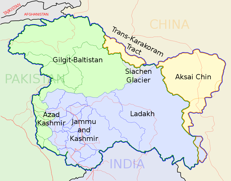
- It is located in the eastern Karakoram range in the Himalayas Mountains, just northeast of the point NJ9842, where the Line of Control between India and Pakistan ends.
- It forms part of the Union Territory of Ladakh.
History of Siachen
- The Trouble began with the drawing up of a UN-brokered India-Pakistan ceasefire line in 1949 following the first war between India and Pakistan.
- The subsequent Karachi accord that year left boundary delineation incomplete.
- In 1984, India launched Operation Meghdoot to capture the 76.4 km-long glacier on the Saltoro ridge.
- However, following the 2003 ceasefire along the Line of Control (LoC) and the Actual Ground Position Line (AGPL) across the Siachen, there has been no shooting.
- While India and Pakistan delineated and accepted the LoC up to Pt. NJ9842, Siachen was left unmarked.
- India claims the area based on the Jammu and Kashmir Instrument of Accession (1947) and Karachi Accord of 1949, which define the ceasefire line beyond NJ9842 as “running Northwards to the glaciers”.
Why is Siachen important?
- The glacier complex includes the Saltoro Ridge that overlooks the Gilgit-Baltistan area of Pakistan-Occupied Kashmir (POK).
- The ridge with high peaks guards the routes leading to Leh, the capital of Ladakh.
- Towards the north, it overlooks and dominates the Shaksgam Valley, which was illegally ceded to China by Pakistan.
- It is close to the Karakoram Pass, which is where the Karakoram Highway passes, connecting Gilgit-Baltistan to Xinjiang province in China.
- Siachen is a wedge between Pakistan and China, keeping the two from linking up deeper towards the north of Kargil and Leh.
- The China factor in the region was never discounted as the China-Pakistan Economic Corridor (CPEC) is geographically close to the Siachen glacier.
- Growing military ties between China and Pakistan brought to India the genuine challenge of a possible ‘two-front war’.
- The shift in the ground dynamics is due to the presence of around 60,000 PLA forces in Eastern Ladakh up to Y Junction, which is close to the critical Daulat Beg Oldi (DBO) airfield.
Siachen Glacier
|

![PMF IAS Environment for UPSC 2022-23 [paperback] PMF IAS [Nov 30, 2021]…](https://pmfias.b-cdn.net/wp-content/uploads/2024/04/pmfiasenvironmentforupsc2022-23paperbackpmfiasnov302021.jpg)
