
Pacific Ocean Currents | Phytoplankton and Fishing
Subscribe to Never Miss an Important Update! Assured Discounts on New Products!
Must Join PMF IAS Telegram Channel & PMF IAS History Telegram Channel
Pacific Ocean Currents
Previous post: Ocean Currents – Factors Responsible for the Formation of Ocean Currents – Effects of Ocean Currents on climate, fishing, navigation, tropical cyclones.
Equatorial Pacific Ocean Currents
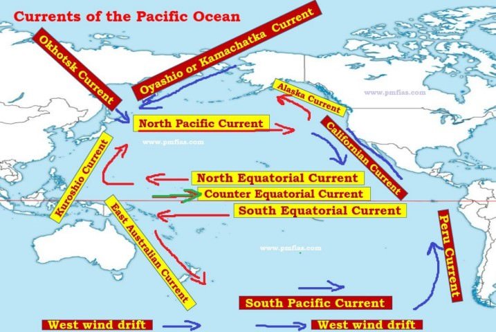
- Under the influence of prevailing trade winds [tropical easterlies], the north equatorial current and the south equatorial current start from the eastern pacific (west coast of Central America) and traverses a distance of 14,500 km moving from east to west.
Counter equatorial current
- This raises the level of western pacific (near Indonesia and Australia) ocean by few centimeters. And this creates a counter-equatorial current which flows between the north equatorial current and the south equatorial current in west-east direction.
Three factors aid the formation of Counter-Equatorial current
- Piling up of water in the western pacific due to trade winds.
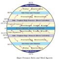
- The presence of doldrums (equatorial low pressure belt) in between the north equatorial current and the south equatorial current. Doldrums are narrow regions with calm (lower) atmospheric conditions. Such conditions aid the backward movement of piled up western pacific waters.
- Piling of water in the western part of oceans due to rotation of earth (this is a very general point).
Question Prelims 2015
What explains the eastward flow of the equatorial counter-current?
- The Earth’s rotation on its axis
- Convergence of the two equatorial currents
- Difference in salinity of water
- Occurrence of the belt of calm near the equator
This question is a very tricky one.
Opinions can vary.
Should wait for Official Answer Key!
My opinion
Point 1: Very general in nature. So, less important.
Point 2: This is the first step. Without convergence of equatorial currents, there may not be counter equatorial current. But convergence occur due to trade winds [winds play a superior role in the formation of ocean currents].
Point 3: Salinity greatly influences vertical currents and its influence on horizontal movement is less significant. So, ruled out.
Point 4: This is the main reason behind counter equatorial current (the backward movement of equatorial waters). Doldrums are calm regions facilitating the backward movement of water.
There is a severe clash between Points 2 and 4. My pick is Option D [more probable].
But why? Because the most important factor what influences the direction of ocean currents is wind.
Kuroshio current
- The north equatorial current turns northward off the Philippines to form the Kuroshio current. Most of it lies in the sub-tropical high pressure belt and its northern part is under the influence of westerlies.
Oyashio Current and Okhotsk current
- There are two more cold currents in the northern Pacific, Oyashio flows across the east coast of Kamchatka Peninsula to merge with the warmer waters of Kuroshio, and the Okhotsk current flows past Sakhlain Islands to merge with the Oyashio current off Hokkaido (Northern Japanese Island).
North-Pacific current
- From the south-east coast of Japan, under the influence of prevailing westerlies, the Kuroshio current turns eastwards and moves as the North-Pacific current, reaches the west coast of North America, and bifurcates into two.
Alaska and Californian current
- The northern branch flows anti-clockwise along the coast of British Columbia and Alaska and is known as the Alaska current. The water of this current is relatively warm as compared to the surrounding waters in this zone.
- The southern branch of the current moves as a cold current along the west coast of USA and is known as the Californian current. The Californian current joins the north equatorial current to complete the circuit.
East Australian current
- Following the pattern in the northern hemisphere, the south equatorial current flows from east to west and turns southwards as the East Australian current. It then meets the South pacific current near Tasmania which flows from west to east.
Peru current or Humboldt Current
- Reaching the south-western coast of South America, it turns northward as the Peru current. It is a cold current, which finally feeds the south equatorial current, thus completing the great circuit.
- And the zone where Peru Cold current meets the warm equatorial ocean waters is an important fishing zone. Why? Read the topic below.
Phytoplankton and Fishing
Mixing zones of Cold and Warm Ocean Currents [Grand Banks] and cold water upwelling zones [Peru coast] are the most productive fishing grounds on earth. Why?
- Phytoplankton are the primary producers in the marine food chain and hence they are called the ‘grass of the sea’.
- Phytoplankton are predominantly microscopic, single celled organisms.
- Some species of algae are large, multicellular and live on the ocean bottom. However, they are insignificant players in the marine ecosystem compared to the phytoplankton as they only inhabit a narrow zone around the coast.
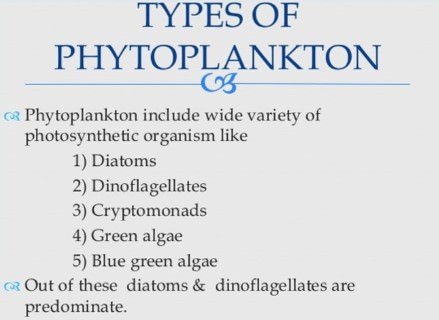
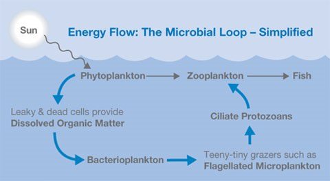
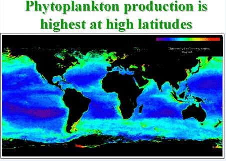
Why are cold and warm current mixing zones the good fishing grounds? Why are tropical waters highly unproductive?
- Algae and other plants are able to photosynthesize to produce organic material from inorganic nutrients.
- And the organic material forms the building block for all animals higher up in the food chain.
- Almost all biomass in the ocean is derived from the phytoplankton and to a lesser extent the benthic algae (found on the bottom of a sea or lake).
- However, there is a fundamental problem phytoplankton in the open ocean have to face. They need both sunlight and nutrients (such as nitrate and phosphate) to be able to photosynthesize.
- Sunlight is only available in the uppermost layers.
- During photosynthesis, the nutrients are quickly used up by phytoplankton so they are not available for long periods in the upper layers under normal circumstances.
This is indeed the case in tropical waters, and as a result they are very unproductive.
- To escape this problem the seawater needs to be mixed regularly to bring the nutrient rich deep waters up to the sunlight zone where the phytoplankton can grow.
This is one of the reasons why cold and warm currents convergence zones [mixing happens – the collision of currents causes mixing] and upwelling zones are very productive.
- Furthermore, in surroundings where atmospheric temperatures are often colder than oceanic temperatures, the top layers of the ocean are cooled by the atmosphere.
- This increases the density of the surface waters and causes them to sink and therefore causes mixing [nutrient deficient water sinks and nutrient rich water is upwelled].
Both of these factors play a role in Icelandic waters, resulting in the very productive ocean environment around Iceland.
Primary References: NCERT Geography, Spectrum’s Geography [Amazon and Flipkart] and Savindra Singh [Amazon and Flipkart]







thank you so much for such a great content