
Glacial Landforms: Erosional and Depositional
Landforms and Cycle of Erosion
- Fluvial Erosional Landforms [Done]
- Fluvial Depositional Landforms [Previous Post]
- Glacial landforms and Cycle of Erosion [This Post]
- Marine landforms and Cycle of Erosion [Next Post]
- Arid landforms and Cycle of Erosion
- Karst landforms and Cycle of Erosion
Glacial Landforms and Cycle of Erosion
- A glacier is a moving mass of ice at speeds averaging few meters a day.
- Types of Glaciers: continental glaciers, ice caps, piedmont glaciers and valley glaciers.
- The continental glaciers are found in the Antarctica and in Greenland. The biggest continental ice sheet in
- Ice caps are the covers of snow and ice on mountains from which the valley or mountain glaciers originate.
- The piedmont glaciers form a continuous ice sheet at the base of mountains as in southern Alaska.
- The valley glaciers, also known as Alpine glaciers, are found in higher regions of the Himalayas in our country and all such high mountain ranges of the world.
- The largest of Indian glaciers occur in the Karakoram range, viz. Siachen (72 km), while Gangotri in Uttar Pradesh (Himalayas) is 25.5 km long.
- A glacier is charged with rock debris which are used for erosional activity by moving ice.
- A glacier during its lifetime creates various landforms which may be classified into erosional and depositional landforms.
Glacial Erosional Landforms
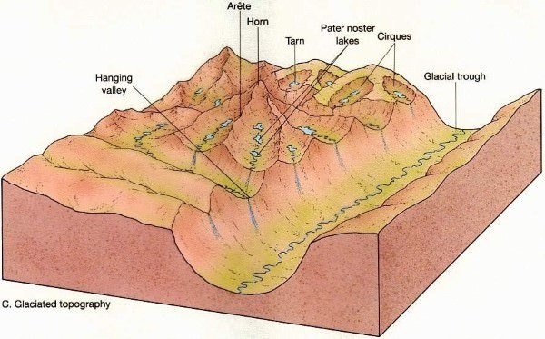
Cirque/Corrie
- Hollow basin cut into a mountain ridge.
- It has steep sided slope on three sides, an open end on one side and a flat bottom.
- When the ice melts, the cirque may develop into a tarn lake.
Glacial Trough
- Original stream-cut valley, further modified by glacial action.
- It is a ‘U’ Shaped Valley. It at mature stage of valley formation.
- Since glacial mass is heavy and slow moving, erosional activity is uniform – horizontally as well as vertically.
- A steep sided and flat bottomed valley results, which has a ‘U’ shaped profile.
Hanging Valley
- Formed when smaller tributaries are unable to cut as deeply as bigger ones and remain ‘hanging’ at higher levels than the main valley as discordant tributaries.
- A valley carved out by a small tributary glacier that joins with a valley carved out by a much larger glacier.
Arete
- Steep-sided, sharp-tipped summit with the glacial activity cutting into it from two
Horn
- Ridge that acquires a ‘horn’ shape when the glacial activity cuts it from more than two sides.
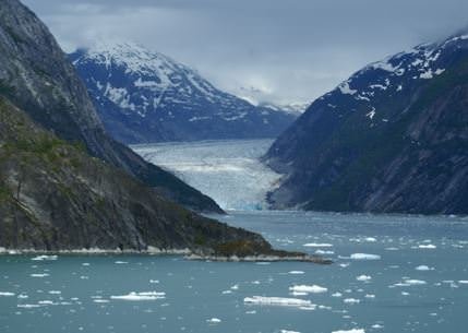
D-Fjord
- Steep-sided narrow entrance-like feature at the coast where the stream meets the coast.
- Fjords are common in Norway, Greenland and New Zealand.
Glacial Depositional Landforms
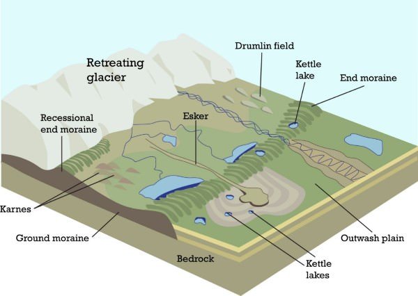
Outwash Plain
- When the glacier reaches its lowest point and melts, it leaves behind a stratified deposition material, consisting of rock debris, clay, sand, gravel etc. This layered surface is called till plain or an outwash plain.
Esker
- Winding ridge of un-assorted depositions of rock, gravel, clay etc. running along a glacier in a till plain.
- The eskers resemble the features of an embankment and are often used for making roads.
Kame Terraces
- Broken ridges or un-assorted depositions looking like hump in a till plain.
Drumlin
- Inverted boat-shaped deposition in a till plain caused by deposition.
Kettle Holes
- Formed when the deposited material in a till plain gets depressed locally and forms a basin.
Moraine
- General term applied to rock fragments, gravel, sand, etc. carried by a glacier.
- Depending on its position, the moraine can be ground moraine and end moraine.
Glacial Cycle of Erosion
Youth
- The stage is marked by the inward cutting activity of ice in a cirque.
- Aretes and horns are emerging. The hanging valleys are not prominent at this stage.
Maturity
- Hanging valleys start emerging. The opposite cirques come closer and the glacial trough acquires a stepped profile which is regular and graded.
Old Age
- Emergence of a ‘U’-shaped valley marks the beginning of old age.
- An outwash plain with features such as eskers, kame terraces, drumlins, kettle holes etc. is a prominent development.
Why are world’s highest mountains at the equator?
- Ice and glacier coverage at lower altitudes in cold climates is more important than collision of tectonic plates. [Glacial erosion is very strong because of huge boulders of rocks carried by the glacial ice that graze the surface. Though ice moves only few meters a day, it can take along it huge rocks that can peal the outer layers.]
- Scientists have solved the mystery of why the world’s highest mountains sit near the equator.
- Colder climates are better at eroding peaks. In colder climates, the snowline on mountains starts lower down, and erosion takes place at lower altitudes.
- In general, mountains only rise to around 1,500m above their snow lines, so it is the altitude of these lines — which depends on climate and latitude — which ultimately decides their height.
- At low latitudes, the atmosphere is warm and the snowline is high. Around the equator, the snowline is about 5,500m at its highest so mountains get up to 7,000m.
- There are a few exceptions [that are higher], such as Everest, but extremely few.
- When you then go to Canada or Chile, the snowline altitude is around 1,000m, so the mountains are around 2.5km.


Amazingly concise and lucid information man, makes me check comment every-time to see if you have mentioned anything here.
From Jan 2019, I will add a lot more.
Thank u .
very precisely and lucidly presented content . THANK YOU
Very important and informative matter … i like it can you send me that material….???
The information is incorrect. Gangotri is not in Uttar Pradesh. It’s in Uttarakhand.