
India: Geographical Extent & Frontiers


India As A Geographical Unit

East-West Extent of Main Land India (Including Pak occupied Kashmir-POK): |
68° 7′ east to 97° 25′ east longitude |
South-North Extent of Main Land India: |
8° 4′ north to 37° 6′ north latitude |
Locational Extent: |
8° 4′ N to 37° 6′ N latitude and 68° 7′ E to 97° 25′ East longitude. |

- The southernmost point of the country is the Pygmalion Point or Indira Point is located at 6° 45′ N latitude.
- North-south extent from Indira Col in Kashmir to Kanniyakumari is 3,214 km.
- East-west width from the Rann of Kachachh to Arunachal Pradesh is 2,933 km.
- With an area of 32,87,263 sq km, India is the seventh largest country of the world.
- India accounts for about 2.4 per cent of the total surface area of the world.

- The Tropic of Cancer passes through the middle of the country dividing it into two latitudinal halves.
- The area to the north of Tropic of Cancer is nearly twice the area which lies to the south of it.
- South of 22° north latitude, the country tapers off over 800 km into the Indian Ocean as a peninsula.
East-West time difference is nearly 2 hrs.
- The earth moves [rotation and revolution] around its axis through 360° in 24 hours. Thus, a difference of 1° longitude will make a difference of 4 minutes in time.
- Therefore the difference of local time between western-most point and eastern-most point is 30 x 4 = 120 minutes or 2 hours.
India, Tropical or Temperate Country?
- The temperate part (north of Tropic of Cancer) is twice the area of tropical part.
- But India has always been treated as a tropical country for two different reasons – physical and cultural.
Physical Geographical Reasons
- The country is separated from the rest of Asia by Himalayas.
- Its climate is dominated by the tropical monsoons and the temperate air masses are blocked by Himalayas.
- Entire area south of the Himalayas is essentially tropical from climatic point of view: Although the night temperatures in Winter at several places in North India may come down to the level of those prevailing in temperate lands, yet clear skies and intense insolation raise the day temperatures to a tropical level.
Cultural Geographical Reasons
- Settlements, diseases, agricultural and primary economic activities are all tropical in nature.
It is primarily because of Himalayas that India is a tropical country.
India’s Frontiers
Data from Ministry Of Home Affairs (Department Of Border Management)
- India has 15106.7 Km of land border running through 92 districts in 17 States and a coastline of 7516.6 Km [6100 km of mainland coastline + coastline of 1197 Indian islands] touching 13 States and Union Territories (UTs).
- Barring Madhya Pradesh, Chhattisgarh, Jharkhand, Delhi, Haryana and Telangana, all other States in the country have one or more international borders or a coastline and can be regarded as frontline States from the point of view of border management.
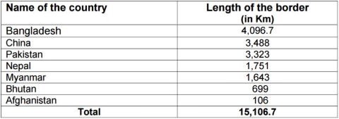
- India’s longest border is with BANGLADESH while the shortest border is with Afghanistan.
- The length of India’s land borders with neighboring countries is as under:
Border with China
- This is the second longest border of India, next only to its border with Bangladesh.
- Five Indian states, namely Jammu and Kashmir, Himachal Pradesh, Uttarakhand, Sikkim and Arunachal Pradesh touch the Indian boundary with China.
- The Sino-Indian border is generally divided into three sectors namely : (i) the Western sector, (ii) the Middle sector, and (iii) the Eastern sector.
The Western Sector
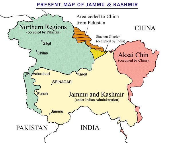
- Separates Jammu and Kashmir state of India from the Sinkiang (Xinjiang) province of China.
- The western sector boundary is largely the outcome of the British policy towards the state of Jammu and Kashmir.
- China claims the Aksai Chin district, the Changmo valley, Pangong Tso and the Sponggar Tso area of north-east Ladakh as well as a strip of about 5,000 sq km down the entire length of eastern Ladakh.
- China also claims a part of Huza-Gilgit area in North Kashmir (ceded to it in 1963 by Pakistan).
The Middle Sector
- Two Indian states of Himachal Pradesh and Uttarakhand touch this border.
The Eastern Sector
- The 1,140 km long boundary between India and China runs from the eastern limit of Bhutan to a point near Diphu pass (Talu Pass) at the trijunction of India, Tibet and Myanmar.
- This line is usually referred to as the Mc Mahon Line after Sir Henry Mc Mahon, then foreign secretary of British India, who negotiated the boundary agreement between Great Britain and Tibet at Shimla accord in 1913-14.
The India-Nepal Boundary
- Five states of India, namely Uttarakhand, Uttar Pradesh, Bihar, West Bengal and Sikkim touch the Nepalese border with India. The border is a porous one with unrestricted movement of goods and people between Indian and Nepal.
- Major portion of Indo-Nepalese border runs in the east-west direction almost along the foothill of the Shiwalik Range.
The India-Bhutan Boundary
- Quite peaceful border and there is no boundary dispute between the two countries.
The Indo-Pakistan Boundary
- The Indo-Pakistan boundary is the result of partition of the country in 1947 under the Radcliffe award of which Sir Cyril Radcliffe was the chairman.
- Jammu and Kashmir, Sir Creek are the major disputed regions.

The India-Bangladesh Border
- India’s 4,096 km long border with Bangladesh is the longest.
- This boundary has been determined under the Radcliffe Award which divided the erstwhile province of Bengal into two parts.
India-Myanmar Boundary
- This boundary runs roughly along the watershed between the Brahmaputra and Ayeyarwady [Irrawaddy].
- It passes through thickly forested regions, with Mizo Hills, Manipur and Nagaland on the Indian side and Chin Hills, Naga Hills and Kachin state on the Myanmar side.
India-Sri Lanka Boundary
- India and Sri Lanka are separated from each other by a narrow and shallow sea called Palk Strait.
- Dhanushkodi on the Tamil Nadu coast in India is only 32 km away from Talaimanar in Jaffna peninsula in Sri Lanka. These two points are joined by a group of islets forming Adam’s Bridge.
Primary References: NCERT Geography, Indian Geography by Kullar [Amazon and Flipkart]


sir you had mentioned naga hills on myanmar side in indo-mynmar boundary, but in map naga hils are shown on indian side can u clarify it
[It passes through thickly forested regions, with Mizo Hills, Manipur and Nagaland on the Indian side and Chin Hills, Naga Hills and Kachin state on the Myanmar side].
It means that some part of Naga Hills are scatted on the Myanmar side too.
You seem to have misunderstood the sentence
ok thank u for the clarifying my doubt
In the Indian geography notes, there is no mention of Jammu and Kashmir & Laddakh as new UTs. Where will I get this ? Should I have to buy new subscription.
It is not updated
Sir when will you be able to put videos for Indian Geography and world geography ? the climatology and other videos are excellent …..kindly put Indian geo videos also,especially INDIAN MONSOON. Thanks in advance…
I will not be making any videos in the near future. Time and Energy issues. Sorry!
how to purchase these notes ???
You can buy them from https://www.pmfias.com
how to purchase these notes ?
Why purchase if you’re getting free!!
Could you please help me how to download/print these contents?
On border with China point, as the Jammu and Kashmir has been turned to union territories, Shall we still count it as five STATES bordering china or shall it become 4 states and a union territory ? Please clarify my doubt
Thanks, PMF IAS for publishing this high-quality content at free of cost, To the point, and best content for UPSC Geography.
Thank You Both PMF and lotus for making my World beautiful and My India Particular.
At present time time 16 state make international boundary in india .
Which state shares its boundry with three nations?
How can I get the updated notes of this geography?
very good quality content but you should update new Uts and states
indian geography is not mentioned in the book. where can i get all the indian geography notes
Adam Bridge or Ram Setu?