PMF IAS Current Affairs
  • Context (DTE): On March 31, 2024, a devastating tornado struck the Mainaguri area of Jalpaiguri district in West Bengal.
  • The tornado lasted for about 10 minutes, resulting in five fatalities and over a hundred injuries.

Tornado Activity in India

  • Tornadoes are rare in India but are mostly reported in eastern states like West Bengal, Odisha, and Jharkhand during the pre-monsoon period. However, evidence suggests that tornadoes have also formed in northwest India.
    • A research paper by scientists from the India Meteorological Department (IMD) in 2016 documented various tornado records in eastern India.
    • The paper reported the highest number of tornadoes in Bengal, with significant fatalities.
    • Tornado activity was also recorded in northwest India, indicating a potential increase in frequency in later years.
  • India has witnessed a rise in tornado occurrences in recent years, leading to significant destruction.
  • Factors such as the warming Bay of Bengal and anomalous wind patterns are believed to contribute to the formation of tornadoes.

How are Tornadoes formed?

A diagram of a tornado Description automatically generated

Understanding Tornadoes

  • A tornado is a violently rotating column of air that extends from a thunderstorm to the ground.
  • Tornadoes can have wind speeds ranging from 105 to 322 kilometres per hour.
  • Cyclonic circulations and troughs are contributing factors to tornado formation.
  • Tornadoes can be either stationary or move at speeds of around 97 km/h.
  • Tornadoes are most common in countries like the United States, Argentina, and Bangladesh.

Monitoring

  • In the US, tornadoes are monitored by meteorologists at NWS using satellite and radar data.
  • India lacks official tornado monitoring, although IMD mentioned the recent West Bengal tornado in a press release.

Air Mass

  • In meteorology, air masses are large bodies of air characterised by nearly uniform temperatures and humidity at a given altitude.

Characteristics

  • Air masses have distinct boundaries and can extend horizontally for hundreds or thousands of kilometres.
  • They may also reach heights as high as the top of the troposphere, approximately 10–18 km (6–11 miles) above the Earth’s surface.
  • It brings constant weather conditions.

Formation

  • Air masses form when the atmosphere remains in contact with a large, relatively uniform land or sea surface for a sufficiently long period, allowing it to acquire the surface’s temperature and moisture properties.
  • Source regions for air masses are the high-pressure belts in the subtropics (resulting in tropical air masses) and around the poles (producing polar air masses).
  • Regions with high pressure and minimal pressure difference or gradient are considered ideal source regions.
  • Mid-latitudes lack major source regions due to dominance by cyclonic and other disturbances.

Classification of Air Mass

gotbooks.miracosta.edu/oceans

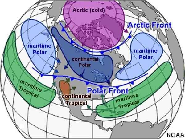
  • Continental Air Mass: Originating from a homogeneous continental surface.
  • Maritime Air Mass: Originating from a homogeneous oceanic surface.

Troughs and Ridges

tan trough ridges map with two axis

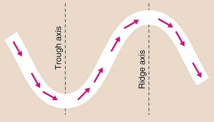
  • A trough is an elongated area of relatively low pressure extending from the centre of a region of low pressure. A trough is roughly U-shaped.
  • To the east of the trough, air usually rises, allowing precipitation to develop.
  • A ridge, on the other hand, looks like an upside-down U.
  • Fairweather is usually associated with ridges.
  • Air under a ridge sinks, which is not conducive to the development of clouds.
Sharing is Caring !!

Newsletter Updates

Subscribe to our newsletter and never miss an important update!

Assured Discounts on our New Products!

Leave a Reply

Your email address will not be published. Required fields are marked *

Newsletter

Never miss an important update!