PMF IAS Test Series for UPSC Prelims Banner Ad

Indian Landslide Susceptibility Map

  • Context (TH): IIT Delhi created India’s first high-resolution landslide susceptibility map.
  • The map provides landslide susceptibility at a high resolution of 100 m.
  • To prepare the map, data of 1.5 lakh landslide events were obtained from Geological Survey of India.
  • Data was also collected information on factors that render an area susceptible to landslide (landslide conditioning factors) such as soil cover, type of soil, number of trees covering the area, distance from roads or mountains, etc.
  • Ensemble machine learning method was used to analyse the data.
  • The map acknowledged some well-known regions of high landslide susceptibility, like parts of the foothills of the Himalaya, the Assam-Meghalaya region, and the Western Ghats.
  • It also revealed some previously unknown places with high risk, such as some areas of the Eastern Ghats, just north of Andhra Pradesh and Odisha.
Ensemble machine learning is when multiple machine learning models are used together to average out an oversize impact from any one model.

Landslides

  • A sudden movement of rock, boulders, earth or debris down a slope under the impact of gravity is termed as a landslide.

Causes of landslides

  • Natural factors: Heavy rainfall, earthquakes, snow melting, undercutting of slopes due to flooding.
  • Anthropogenic factors: Excavation, cutting of hills and trees, overgrazing by cattle, etc.

Factors influencing landslides

  •  Lithology, geological structures like faults, hill slopes, drainage, geomorphology, land use and land cover, soil texture and depth, and weathering of rocks.

Types

  1. Based on materials involved: Rock, debris, soil, loose mud.
  2. Based on movement of material: Fall, topple, slide, rotational slide or translational slide.
  3. Based on flow of material: Debris flow, Earth flow, Mudflow, Creep.

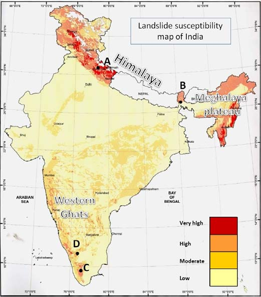
Landslides in India: Status

  • India is among the top five landslide-prone countries globally.
  • At least one death per 100 sq km is reported per year due to landslides.
  • Excluding snow-covered areas, approximately 12.6% of the country’s geographical land area is prone to landslides.
  • Biggest cause of landslides in India: Variability in rainfall patterns.

National landslide susceptibility map

NDMA Guidelines on Landslides

  • Regularly updating the inventory of landslide incidences in the country.
  • Landslide hazard zonation mapping in macro and meso scales after consultation with Border Roads Organization, state governments and local communities.
  • Pilot projects to be taken up in different regions of the country to carry out detailed studies and monitoring of select landslides to assess their stability status and estimate risk.
  • Setting up early warning systems depending on the risk evaluation and cost-benefit ratio.
  • Training and capacity-building measures for professionals and organizations working in the field of landslide management.
  • New codes & guidelines to be developed for landslide studies and existing ones have to be revised.
  • Establishing an autonomous National Center for Landslide Research, Studies and Management.
Sharing is Caring !!

Newsletter Updates

Subscribe to our newsletter and never miss an important update!

Assured Discounts on our New Products!

Leave a Reply

Your email address will not be published. Required fields are marked *

Newsletter

Never miss an important update!