
Marginal seas of the world | Bay, Gulf, Strait, Isthmus
Subscribe to Never Miss an Important Update! Assured Discounts on New Products!
Must Join PMF IAS Telegram Channel & PMF IAS History Telegram Channel
Last updated on April 18, 2024 6:40 PM
Marginal Seas
- In oceanography, a marginal sea is a sea partially enclosed by islands, archipelagos, or peninsulas.
- Some of the major marginal seas include the Arabian Sea, Baltic Sea, Bay of Bengal, Bering Sea, Black Sea, Gulf of California, Gulf of Mexico, Mediterranean Sea, Red Sea, and all four of the Siberian Seas (Barents, Kara, Laptev, and East Siberian).
- The primary differences between marginal seas and open oceans are associated with depth and proximity to landmasses.
- Marginal seas, which are generally shallower than open oceans, are more influenced by human activities, river runoff, climate, and water circulation.
Important Marginal Seas:
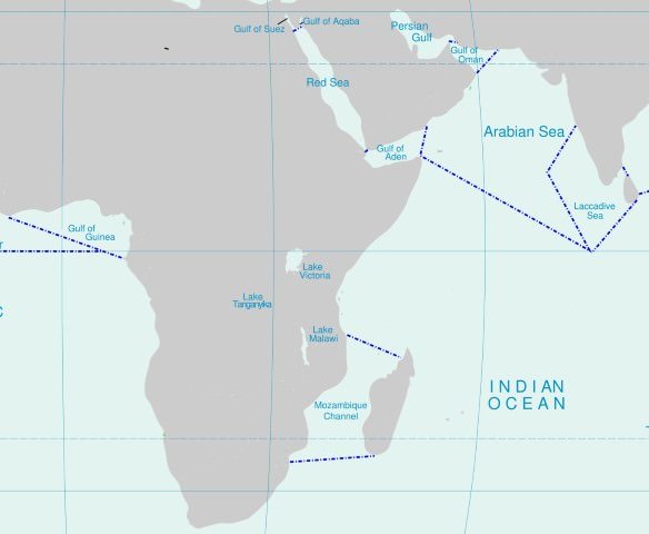
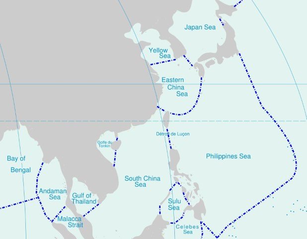
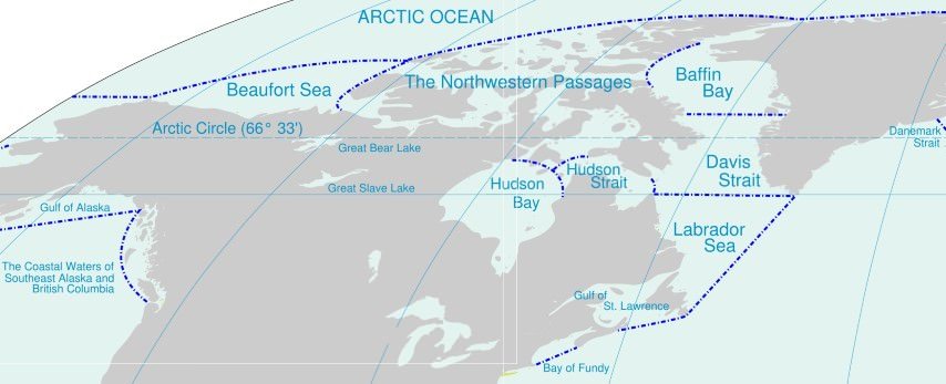
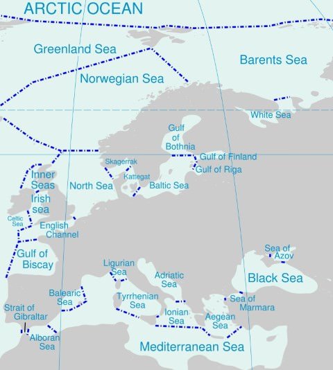
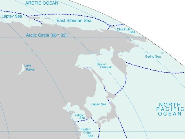
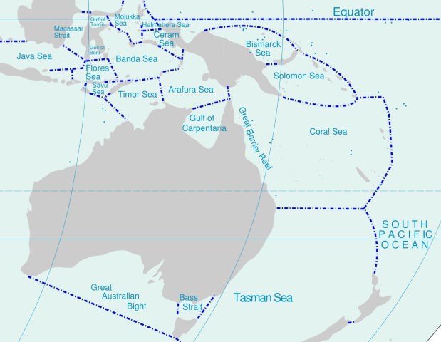
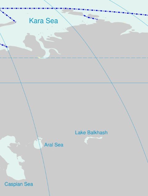
Image source: https://upload.wikimedia.org/wikipedia/commons/e/e4/Oceans_and_seas_boundaries_map-en.svg
Marginal seas of the world
- Important marginal seas are mentioned below.
Marginal seas of the Arctic Ocean
- Barents Sea
- The Irish Sea
Marginal seas of the Atlantic Ocean
- Argentine Sea
- Caribbean Sea
- English Channel
- Gulf of Mexico
- Hudson Bay
- Irish Sea
- Labrador Sea
- Mediterranean Sea
- North Sea
- Norwegian Sea
- Scotia Sea
Marginal seas of the Indian Ocean
- Andaman Sea
- Arabian Sea
- Bay of Bengal
- Java Sea
- Persian Gulf
- Red Sea
- Sea of Zanj
Marginal seas of the Mediterranean Sea
Major conflict zones lie on the east of Mediterranean. Also recent refugee crisis is constantly in news. Hence the locations from the region are important for prelims.
- Adriatic Sea
- Aegean Sea
Marginal seas of the Pacific Ocean
- Bering Sea
- Celebes Sea
- Coral Sea
- East China Sea
- Philippine Sea
- Sea of Japan
- Sea of Okhotsk
- South China Sea (another important conflict zone)
- Tasman Sea (between Australia and New Zealand)
- Yellow Sea (by the Korean Peninsula)
Other seas
- The Caribbean Sea is sometimes defined as a marginal sea, sometimes as a Mediterranean sea.
- The Caspian Sea is also sometimes defined as a marginal sea, and also the Dead Sea.


Human Impact on marginal seas
- Marginal seas are more susceptible to pollution than open ocean regions because of the high concentration of human activities near coastlines and rivers.
- The greatest human impact on marginal seas is related to the fisheries industry.
- Ninety percent of the world’s fisheries exist within coastal waters that are located less than 200 kilometers (124 miles) from the shoreline.
- Other human activities that have adversely affected marginal seas include industrial sewage disposal, offshore oil drilling, and accidental releases of pollutants, including petroleum products, radioactive waste, detergents, and plastics.
- Pollutants from the nearby landmasses are introduced into marginal seas in concentrations that are thousands of times greater than in open oceans.
Phytoplankton Bloom (Algal Bloom) in Marginal Seas
- The Mediterranean Sea and the Black Sea are marginal seas found in proximity to one another. The color difference shown here is due to a phytoplankton bloom occurring in the Black Sea.
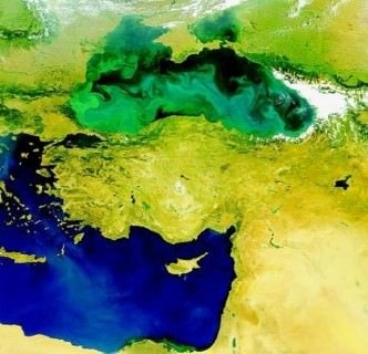
- Phytoplankton are good as fish feed on them. But when they proliferate indiscriminately, they consume too much oxygen during nights, thus depriving other marine organisms of oxygen.
- For example, the discharge of domestic sewage leads to elevated nutrient concentrations (particularly phosphates) which can result in harmful algal blooms.
Biomass Production and Primary Productivity
- Marine biomass production originates with primary productivity, which in turn is affected by the availability of sunlight, carbon dioxide, nutrients such as nitrates and phosphates, and trace elements.
- Marginal seas generally exhibit intermediate levels of primary production, with the highest rates found in coastal upwelling regions and the lowest primary production occurring in open ocean regions.
- Hence, the highest biomass production rates occur in coastal upwelling zones, the lowest in open oceans regions, and intermediate rates in marginal seas.
- For near shore regions, the dominant processes influencing primary productivity are river runoff, water column mixing, and turbidity.
- River runoff and water column mixing introduce dissolved nutrients, trace elements, and suspended particles into the photic (light) zones of near shore regions.
- Although the addition of dissolved nutrients and trace elements to coastal waters and marginal seas serves to increase primary production, the addition of suspended particles increases water turbidity, which results in reduced sunlight penetration and decreased primary productivity.
Water Circulation in Marginal Seas
- Water circulation patterns in marginal seas depend largely on shape of the sea, fresh-water input (e.g., river runoff and precipitation) and evaporation.
- If river runoff and precipitation exceed evaporation, as is the case in the Black and Baltic Seas, the excess fresh water will tend to flow seaward near the sea surface.
- If evaporation exceeds river runoff and precipitation, as in the Mediterranean Sea, the marginal sea water becomes saltier, then sinks and flows towards the less salty open ocean region.
Circulation Patterns in Major Marginal Seas
Black Sea and Baltic Sea
- The Black Sea and Baltic Sea basins both possess sills that restrict subsurface water circulation.
- While the surface waters of the Black and Baltic Seas are able to flow over the sills and introduce lower salinity water into the open ocean, the flow of the saltier subsurface waters is blocked by these sills.
- This type of subsurface-water restriction often leads to stagnation, which may eventually result in local oxygen depletion.
Mediterranean Sea
- The Mediterranean Sea, which is divided by a 400 meter sill into two sub basins, is connected to the Atlantic Ocean via the Straits of Gibraltar, to the Black Sea via the Bosporus Strait, and to the Red Sea via the manmade Suez Canal.
- Atlantic Ocean water enters this marginal sea through the Straits of Gibraltar as a surface flow. This ocean water replaces a fraction of the water that evaporates in the eastern Mediterranean Sea.
- In Mediterranean Sea evaporation exceeds precipitation and hence salinity increases.
Gulf of Mexico
- Compared to the Black, Baltic and Mediterranean Seas, the Gulf of Mexico is a much less complex marginal sea.
- The Gulf of Mexico is connected to the Atlantic Ocean via the Straits of Florida and the Caribbean Sea via the Yucatán Strait.
- In the northern Gulf of Mexico region, Mississippi River runoff influences surface waters as far as 150 meters away from the shore, resulting in salinities as low as 25.
- A unique feature of the Gulf of Mexico’s surface circulation pattern is the Loop Current, which results from the Caribbean Current entering the Gulf of Mexico through the Yucatán Strait and upon arrival, turning in a clockwise direction and “looping” around a warm “dome” of Gulf of Mexico surface water [More under ocean currents].
Bays, gulfs, and Straits
- Bays, gulfs, and straits are types of water bodies that are contained within a larger body of water near land.
- These three water bodies are usually located at important points of human activities; thus, conflicts with nature and neighbors are common.
Bays
- A bay is a small body of water that is set off from a larger body of water generally where the land curves inward.
- In simple words, bay is a water body surrounded on three sides by land with the fourth side (mouth) wide open towards oceans. (In Gulfs, the mouth is narrow).
- A bay is usually smaller and less enclosed than a gulf.
- Example: The Bay of Pigs (Cuba), Hudson Bay (Canada), Bay of Bengal etc.
- An example of a bay at a river’s mouth is New York Bay, at the mouth of the Hudson River (Hudson Estuary).
Guantánamo Bay
- Guantánamo Bay is a sheltered inlet within the Caribbean Sea.
- During the Spanish-American War in 1898, the United States gained access to the outer harbor of Guantánamo Bay.
- Through an agreement signed with Cuba in 1903, the United States obtained the right to maintain a naval base at Guantánamo Bay.
- In 1934, a treaty reaffirmed the U.S. right to lease the site. The treaty gave the United States a perpetual lease on Guantánamo Bay.
- The most infamous Guantánamo Bay prison is here.
Gulfs
- A gulf is a large body of water, sometimes with a narrow mouth, that is almost completely surrounded by land. The world’s largest gulf is the Gulf of Mexico.
- Examples of other gulfs include the Gulf of California, Gulf of Aden (between the Red Sea and the Arabian Sea), and the Persian Gulf (between Saudi Arabia and Iran).
- The Persian Gulf is important with respect to world energy because petroleum is transported through its waters in oil tankers.
Straits
- A strait is a narrow passageway of water, usually between continents or islands, or between two larger bodies of water.
- The Strait of Gibraltar is probably the world’s most famous strait. It connects the Atlantic Ocean on its west with the Mediterranean Sea on its east.
- Two other well-known straits are the Strait of Bosporus and the Strait of Hormuz.
- The Strait of Bosporus connects the Black Sea (from the north) and the Sea of Marmara (from the south), and splits northwestern Turkey.
- The Strait of Hormuz is located at the southeastern end of the Persian Gulf. It is a narrow waterway that can be (and has been) controlled to prevent ships from sailing through the gulf.
Choke Point
- When a body of water such as a strait is capable of being blocked or even closed in order to control transportation routes, the body is called a “choke point.”
- Historically, the Strait of Gibraltar has been one of the world’s most important choke points.
- However, the Strait of Hormuz has become an important choke point in recent years because of increasing Middle East tensions.
- The Strait is surrounded by the United Arab Emirates and Oman (on one side) and Iran (on the other side).
Isthmus
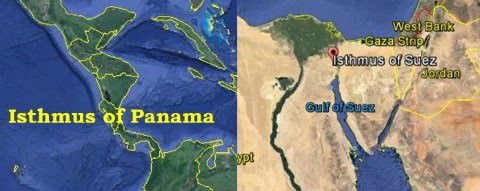
- Isthmus is the land-equivalent of a strait. i.e., a narrow strip of land connecting two larger land masses.
- Example: Isthmus of Panama and Isthmus of Suez.
Primary reference: Wikipedia
Last updated on April 18, 2024 6:40 PM






GOOD EVENING SIR,
PLEASE EXPLAIN WATER CIRCULATION IN BLACK SEA AND BALTIC SEA AND GULF OF MEXICO. ITS NOT THAT MUCH CLEAR. THANKYOU.
First, you need to understand what a sill is. It is a wall like feature (simply, a barrier) underwater that separates two water bodies [See image: https://goo.gl/9ix4IZ%5D. In most of the cases, one of the water bodies is very narrow. E.g. Gibraltar sill separates subsurface water layers of Mediterranean Sea (narrow water body) and Atlantic Ocean, a sill separates subsurface water layers of Red Sea (narrow sea) from Indian Ocean, etc.
Take a look at this map to understand ocean bottom topography – https://goo.gl/Ni8T7a
There is exchange of water between two water bodies (layers of water) above the sill. Layers of water lying lower than the peak of the sill have negligible exchange of water as the sill stands between them.
*Circulation Patterns in Major Marginal Seas*
# Mediterranean Sea, Black Sea and Baltic Sea
All these seas are closed seas with a very narrow opening to the Atlantic Ocean. [Mediterranean Sea opens up into Red Sea as well through Suez Canal]
They possess sills that separate them from the Atlantic Ocean [sills lie just under water surface (400-1000 meters below the water surface)]
Layers of water above the sill flow freely and this leads to exchange of water between the above mentioned seas and the Atlantic.
Movement of water lower than the sill is not possible as the sill acts as a physical barrier. Hence these small and closed seas have subsurface waters of abnormally high salinity [this is because of the sill prevents the exchange of water — When water at top layers evaporate the water becomes more saline. Saline water is denser and hence it sinks to the bottom. This highly saline water becomes stagnant because of the sill that obstructs its flow]
# Gulf of Mexico
Gulf of Mexico has a very wide opening to the Atlantic. Here sub-surface water and water at lower levels flow comparatively freely (https://goo.gl/YkXAhJ) unlike in the Black Sea or other closed seas.
Also, ocean currents are stronger in this sea as it is wide open at the surface (Read ocean currents in Atlantic to know more: http://www.pmfias.com/atlantic-ocean-currents-sargasso-sea-gulf-stream-north-atlantic-drift-benguela-current/). There is a lot of fresh water inflow from the Mississippi River. Hence circulation here is quite different from the Black Sea and Mediterranean Sea.
To understand this concept you need to understand Ocean Relief features explained in the previous topic: https://goo.gl/CsI2I5.
Also, I suggest you to start from the very basics of Geography so that you can understand the concepts better. All Geography posts are available here: https://goo.gl/fdCvFs
Thank you sir. It’s quite clear now and sorry sir I won’t use all caps from now onwards.
Next time please don’t use All Caps. Use Mixed Letters instead. ALL CAPS in typing is usually used to Yell or Shout at someone.
sir why dont make video. video is very helpful to understand .
Busy with other work. No new videos for Upsc 2018.
Sir aapse direct connect krne ka koi r option hai
You can write me here https://www.pmfias.com/contact
sir can i purchases economies note for upsc
Sorry! I don’t have any notes on Economy.
sir you can help me any type for economies notes please help us
The best available solution for Indian Economy https://www.youtube.com/playlist?list=PLAMBum9_RkuPPGvD7HI9wfsDSxWwJYz94
Sir, isn’t the Irish sea a part of North Atlantic Ocean? In the above notes Irish sea has been mentioned both under Arctic and Atlantic .
Thank You for your hardwork !!!
May God bless !!!