
Fronts | Types of Fronts: Stationary Front, Warm Front, Cold Front & Occluded Front
Understanding Front Formation and Types of Fronts is important to understand the formation of Mid-latitude cyclones [temperate cyclones or extra-tropical cyclones] and the dominant weather patterns of mid latitudes.
Fronts
- Fronts are the typical features of midlatitudes weather (temperate region – 30° – 65° N and S). They are uncommon (unusual) in tropical and polar regions.
- Front is a three dimensional boundary zone formed between two converging air masses with different physical properties (temperature, humidity, density etc.).
- The two air masses don’t merge readily due to the effect of the converging atmospheric circulation, relatively low diffusion coefficient and a low thermal conductivity.
Front Formation
- The process of formation of a front is known as Frontogenesis (war between two air masses), and dissipation of a front is known as Frontolysis (one of the air masses win against the other).
- Frontogenesis involves convergence of two distinct air masses. Frontolysis involves overriding of one of the air mass by another.
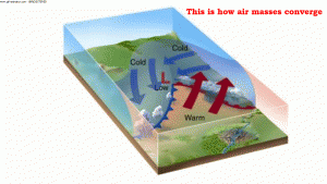
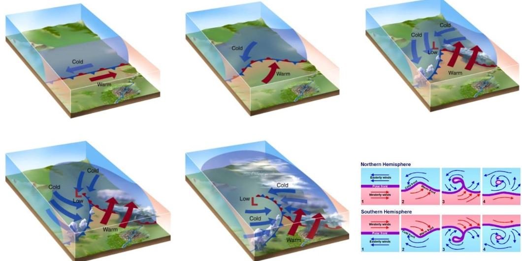
- In northern hemisphere Frontogenesis (convergence of air masses) happens in anti-clockwise direction and in southern hemisphere, clockwise direction. This is due to Coriolis effect.
- Mid-latitude cyclones or temperate cyclones or extra-tropical cyclones occur due to frontogenesis.
General Characteristics of Fronts
- The temperature contrast influences the thickness of frontal zone in an inversely proportional manner, i.e., two air masses with higher temperature difference do not merge readily. So the front formed is less thick.
- With a sudden change in temperature through a front, there is a change in pressure also.
- Front experiences wind shift, since the wind motion is a function of pressure gradient and Coriolis force.
Wind Shift: A change in wind direction of 45 degrees or more in less than 15 minutes with sustained wind speeds of 10 knots or more throughout the wind shift.
1 knot = 1.852 kmph
1 Nautical Mile = 1.852 km
- The frontal activity is invariably associated with cloudiness and precipitation because of ascent of warm air which cools down adiabatically, condenses and causes rainfall.
Adiabatic Lapse Rate – Latent Heat of Condensation
- The intensity of precipitation depends on the slope of ascent and amount of water vapour present in ascending air.
Classification of Fronts
- Based on the mechanism of frontogenesis and the associated weather, the fronts can be studied under the following types.
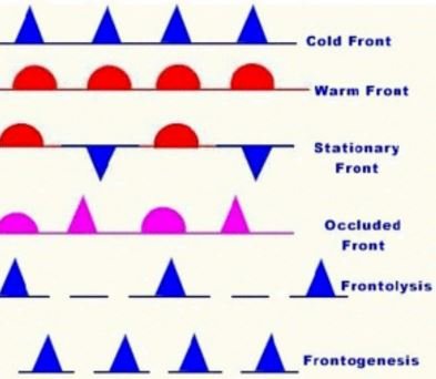
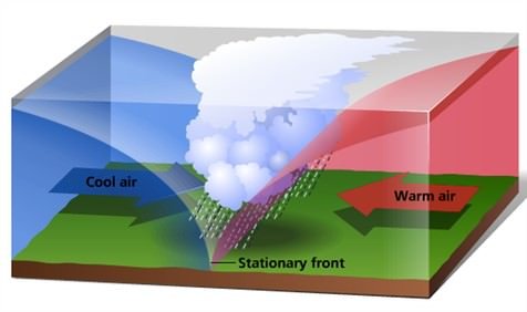
Stationary Front
- When the surface position of a front does not change (when two air masses are unable to push against each other; a draw), a stationary front is formed.
- The wind motion on both sides of the front is parallel to the front.
- Warm or cold front stops moving, so the name stationary front.
- Once this boundary resumes its forward motion, becomes a warm front or cold front.
Weather along a stationary front
- Cumulonimbus clouds are formed. Overrunning of warm air along such a front causes frontal precipitation.
- Cyclones migrating along a stationary front can dump heavy amounts of precipitation, resulting in significant flooding along the front.
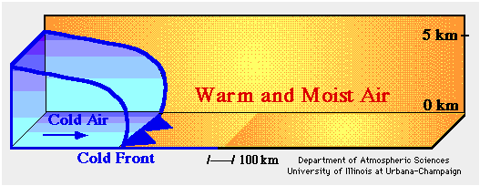
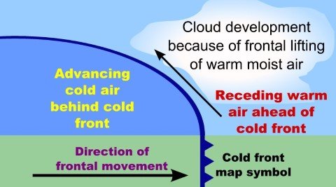
Cold Front
- Such a front is formed when a cold air mass replaces a warm air mass by advancing into it or that the warm air mass retreats and cold air mass advances (cold air mass is the clear winner).
- In such a situation, the transition zone between the two is a cold front.
- Cold front moves up to twice as quickly as warm fronts.
- Frontolysis begin when the warm air mass is completely uplifted by the cold air mass.
Gif Image – Open in a new tab to view the animation or View in Power Point [Full Screen Mode]
Weather along a cold front
- The weather along such a front depends on a narrow band of cloudiness and precipitation.
- Severe storms can occur. During the summer months thunderstorms are common in warm sector.
- In some regions like USA tornadoes occur in warm sector.
- Produce sharper changes in weather. Temperatures can drop more than 15 degrees within the first hour.
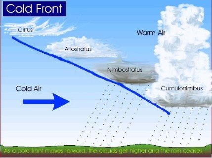
Cloud formation along a cold front
- The approach of a cold front is marked by increased wind activity in warm sector and the appearance of cirrus clouds, followed by lower, denser altocumulous and
- At actual front, dark nimbus and cumulonimbus clouds cause heavy showers. A cold front passes off rapidly, but the weather along it is violent.
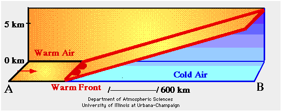
Warm Front
- It is a sloping frontal surface along which active movement of warm air over cold air takes place (warm air mass is too weak to beat the cold air mass).
- Frontolysis (front dissipation) begin when the warm air mass makes way for cold air mass on the ground, i.e. when the warm air mass completely sits over the cold air mass.
Gif Image – Open in a new tab to view the animation or View in Power Point [Full Screen Mode]
Weather along a warm front
- As the warm air moves up the slope, it condenses and causes precipitation but, unlike a cold front, the temperature and wind direction changes are gradual.
- Such fronts cause moderate to gentle precipitation over a large area, over several hours.
- The passage of warm front is marked by rise in temperature, pressure and change in weather.
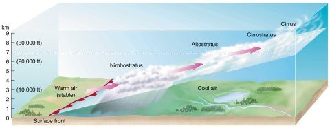
Clouds along a warm front
- With the approach, the hierarchy of clouds is—-cirrus, stratus and nimbus. [No cumulonimbus clouds as the gradient is gentle]
- Cirrostratus clouds ahead of the warm front create a halo around sun and moon.
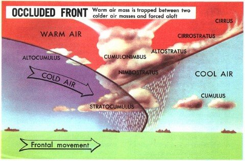
Occluded Front
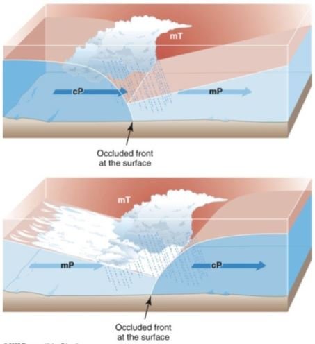
- Occlusion: Meteorology a process by which the cold front of a rotating low-pressure system catches up the warm front, so that the warm air between them is forced upwards.
- Such a front is formed when a cold air mass overtakes a warm air mass and goes underneath it.
- Frontolysis begin when warm sector diminishes and the cold air mass completely undertakes the warm sector on ground.
- Thus, a long and backward swinging occluded front is formed which could be a warm front type or cold front type occlusion.
Weather along an occluded front
- Weather along an occluded front is complex—a mixture of cold front type and warm front type weather. Such fronts are common in west Europe.
- The formation Mid-latitude cyclones [temperate cyclones or extra-tropical cyclones] involve the formation of occluded front.
Clouds along an occluded front
- A combination of clouds formed at cold front and warm front.
- Warm front clouds and cold front clouds are on opposite side of the occlusion.
| Stationary Front | Tie = No clear Winner |
| Cold Front | Cold Air mass is the clear winner. |
| Warm Front | The warm air mass picks up a fight. But fails to beat the cold air mass.
Cold Air mass is the winner. |
| Occluded Front | Cold Front + Warm Front
Double win for cold air mass |
| Cold Front, Warm Front and Occluded front are examples of Temperature Inversion. | |
Temperature Inversion – Types – Effects on Weather
Primary References: NCERT Geography, Spectrum’s Geography [Amazon and Flipkart], and SavindraSingh [Amazon and Flipkart] and many websites.


Hi, could you do a post on frontogenesis and weather instability?