
Coastal Regulation Zone – CRZ


Coastal Regulation Zone (CRZ)
GS 3 – Conservation
- NGT stayed sand mining in CRZ areas of Udupi District, Karnataka.
- Some sections demand a complete ban on sand mining in CRZ areas.
- So let’s take a look at what exactly are CRZ areas and which laws govern them.
Coastal Regulation Zone (CRZ) Notification 1991
- Issued by MoEF under Environment (Protection) Act, 1986.
- Mandate: Take measures to protect and conserve our coastal environment.
Shortcomings of CRZ Notification 1991
- Uniform regulations for the entire Indian coastline without taking into account the diversity in terms of biodiversity, demographic patterns, natural resources, etc.
- 1991 Notification laid no clear procedure for obtaining CRZ clearance.
- Post clearance monitoring and enforcement mechanism was not laid out.
- Measures/rules to check pollution emanating from land based activities were not included.
- Caused hardships to traditional communities living in ecologically sensitive coastal stretches (fishermen, slum dwellers, etc.).
Coastal Regulation Zone (CRZ) Notification 2011
- Many amendments were made to CRZ notification 1991 and all these amendments were consolidated in the CRZ Notification 2011.
- The 2011 Notification takes into account and address all the above mentioned issues.
Objectives
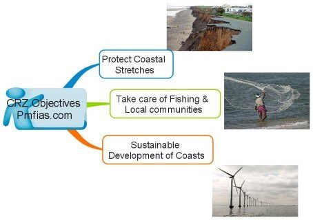
- To conserve and protect coastal stretches;
- To ensure livelihood security to the fishing & local communities living in the coastal areas;
- To promote development in a sustainable manner based on scientific principles, taking into account natural hazards and sea level rise.
Classification of coastal zones under CZR Notification 2011
- CRZ-I (ecologically sensitive areas likes mangroves, coral reefs, biosphere reserves etc.),
- CRZ-II (built-up area – villages and towns are that are already well established),
- CRZ-III (Rural and urban areas that are not substantially developed), and
- CRZ-IV (water areas upto the territorial waters and the tidal influenced water bodies).
- A separate draft Island Protection Zone Notification has been issued for protection of the islands of Andaman & Nicobar and Lakshadweep under Environment (Protection) Act, 1986.
CRZ-I category
1) Ecologically sensitive areas and the geomorphological features that play a primary role in maintaining the integrity of the coast.
- Mangroves, Corals and coral reefs;
- Sand Dunes, Mudflats which are biologically active;
- National parks and other protected areas including Biosphere Reserves encompassing;
- Salt Marshes;
- Turtle nesting grounds;
- Horse shoe crabs habitats;
- Sea grass beds;
- Nesting grounds of birds;
- Areas or structures of archaeological importance and heritage sites;
2) The area between Low Tide Line and High Tide Line.
Activities permissible in CRZ-I
1) No new construction shall be permitted in CRZ-I except
- Projects relating to the Department of Atomic Energy;
- Construction of trans-harbor sea link and roads without affecting the tidal flow of water, between LTL and HTL. Etc.
2) Between Low Tide Line and High Tide Line in areas which are not ecologically sensitive, the following may be permitted;
- Exploration and extraction of natural gas;
- Construction of basic amenities like schools, roads, etc. for traditional inhabitants living within the biosphere reserves;
- Salt harvesting by solar evaporation of seawater;
- Desalination plants;
- Storage of non-hazardous cargo such as edible oil, fertilizers within notified ports;
CRZ-II category
- Areas which are developed upto to the shoreline and falling within municipal limits.
Activities permissible in CRZ-II
- Buildings are permissible on the landward side of the hazardous line.
- Other activities such as desalination plants are also permissible.
- Some construction is permitted only as per guidelines specified by the notification.
CRZ-III category
- Areas that are relatively undisturbed and do not fall under either in Category I or II and also include rural and urban areas that are not substantially developed.
Activities permissible in CRZ-III
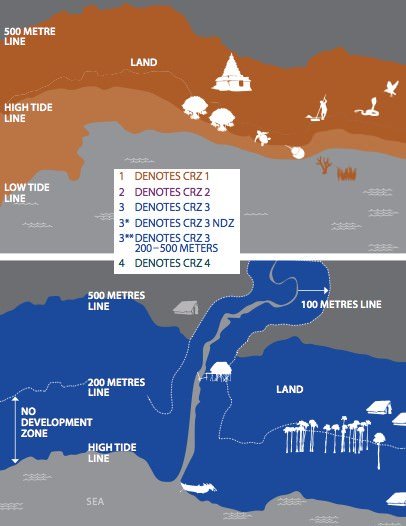
- Between 0-200 metres from HTL is a No Development Zone where no construction shall be permitted.
- Only certain activities relating to agriculture, forestry, projects of Department of Atomic Energy, mining of rare minerals, salt manufacture, regasification of petroleum products, non-conventional energy sources and certain public facilities may be permitted in this zone.
- Between 200-500 metres of HTL, those permitted in 0-200 metres zone, construction of houses for local communities and tourism projects are permissible.
CRZ-IV category
- The aquatic area from low tide line upto territorial limits is classified as CRZ-IV including the area of the tidal influenced water body.
Activities permissible in CRZ-IV
- There is no restriction on the traditional fishing undertaken by local communities.
- No untreated sewage or solid waste shall be let off or dumped in these areas.
Provisions for the Fisherfolk Communities under CZR Notification 2011
- Stated objectives of the Notification are
- to ensure livelihood security to the fisher communities, and
- to promote development through sustainable manner.
Provisions that address the issues relating to fishermen community
Water area up to 12 nautical miles and the tidal influenced water bodies have been included under the Coastal Regulation Zone areas in order to:
- control the discharge of untreated sewage, effluents and the disposal of solid wastes as such activities endanger the fish and their ecosystem;
- Conserve and protect marine habitats like coral reefs, sea grass beds etc. which act as spawning, nursery and rearing grounds for fish and fisheries;
- Regulate activities in the marine and coastal waters such as dredging, sand mining, discharge of waste from ships etc.;
- Enable studies with regard to the impact of climate change and disasters which have serious impacts on the livelihood of the fisherfolk communities;
- No restrictions are being imposed on any fishing activities under CRZ 2011;
- Coastline shall be demarcated and regulated based on high eroding category, the medium eroding category or the stable sites category;
- Coastal Zone Management Plans shall demarcate fishing Zones and breeding areas;
- Coastal Zone Management Authority takes comments on the draft Coastal Zone Management Plan from stakeholders including fisherman; and
- The Notification allows infrastructural facilities for the local fishing communities to be constructed in the CRZ-III area.
Measures to Combat Pollution under CRZ 2011
All coastal states are required to ensure that:
- the existing practice of discharging untreated waste and effluents is phased out within a period not exceeding two years.
- Dumping of solid waste is phased out within one year from the commencement of the Notification.
- An Action Plan is to prepared for dealing with pollution in coastal areas and waters and in a time bound manner.
- The Action Plan is submitted to MoEF who would provide technical and financial assistance.
Procedure for Clearances
Unlike the 1991 Notification, a specific procedure has been provided in the 2011 Notification for obtaining project clearance. This procedure is as follows:
- Rapid Environment Impact Assessment (EIA) Report;
- Disaster Management Report and Risk Management Report;
- CRZ map indicating HTL and LTL demarcated;
- No Objection Certificate from the concerned Pollution Control Boards;
- The clearance accorded to the projects shall be valid for the period of five years.
What is the post-clearance monitoring mechanism?
- It shall be mandatory for the project management to submit half-yearly compliance reports.
Enforcement Measures
- The CZMAs at the State level and the NCZMA, at the Central level shall be strengthened in a time bound manner for effectively enforcing the Notification.
- The Notification lays out the method and the time frame in which actions shall be taken against any violations.
Special dispensations given to ecologically sensitive areas
- Sunderbans, Gulf of Khambat and Gulf of Kutch, Malvan, Achra-Ratnagiri in Maharashtra, Karwar and Coondapur in Karnataka, Vembanad in Kerala, Bhaitarkanika in Orissa, Coringa in East Godavari and Krishna in Andhra Pradesh would be declared as Critical Vulnerable Coastal Areas (CVCA) and the integrated management plan would be prepared for each of these areas in consultation with the local communities.
- Beaches such as Mandrem, Morjim, Galgiba and Agonda in Goa have been designated as turtle nesting sites and protected under the Wildlife Protection Act, 1972. No developmental activities shall be permitted in these areas.
Island Protection Zone Notification
- There are about 500 islands in Andaman & Nicobar and about 30 in Lakshadweep.
- The geographical areas of some of these islands are so small that in most of the cases the 500 metres Coastal Regulation Zone regulations overlap.
- Hence, a separate Notification is being issued which takes into account the management of the entire island (except for four islands of A&N which include North Andaman, Middle Andaman, South Andaman and Great Nicobar).
- Objectives of the IPZ Notification, 2011: Same as objectives of CZR 2011.
Jurisdiction of IPZ Notification 2011
- For the four islands namely, North Andaman, Middle Andaman, South Andaman and Great Nicobar, the Notification applies to areas within 500 metres from the High Tide Line along the seafront, while for all other islands of A&N and Lakshadweep the entire geographical area, including the water area upto 12 nautical miles falls within purview of the Notification.
Coastal Regulation Zone (CRZ) committee report
- The committee was headed by Sailesh Nayak (Former Secretary of the Earth Sciences Ministry).
- It was commissioned in June 2014.
- It was commissioned after states expressed dissatisfaction regarding the limitations set by the CRZ notification of 2011.
- The report was submitted in January 2015.
Recommendations
- The committee recommended several relaxations in the terms set by the 2011 notification.
- The recommendations have been put forth with the objective of giving a boost to tourism, port construction and real estate.
Priority to Local Planning
- It endorsed the dilution of regulatory powers held by the central government in coastal areas.
- The committee has suggested that the central government’s role in coastal areas be limited to environmental clearances and regulating environmentally-sensitive areas.
- Construction, except those requiring environmental clearances, should fall under the ambit of the state and local planning bodies instead of being regulated by centre.
- Urban planning rules prepared by local authorities be prioritized for slum development and rehabilitation instead of the 2011 regulations.
Relaxing HTL limits
- For rural areas with a population density of over 2,161 persons/sq km, the “no-development buffer zone” be limited to 50m from the High Tide Line (HTL).
- For other areas, the buffer has been recommended at 200m from the HTL.
Boost to infrastructure and Tourism
- Allowing reclamation of lands for specific infrastructure such as ports, bridges and fisheries-related structures for the “larger public interest”.
- The recommendations make a case for allowing
- temporary tourist facilities in no-development zones in coastal areas as well as
- permanent structures on the landward sides of national/state highways.
Source: http://goo.gl/Ehjd9d


