Precision Farming, Geoinformatics for Precision Farming
Subscribe to Never Miss an Important Update! Assured Discounts on New Products!
Must Join PMF IAS Telegram Channel & PMF IAS History Telegram Channel
- India’s agriculture is focused on production which isn’t necessarily translating into productivity & profitability.
- Shrinking land, depleting water and other related resources in agriculture are a serious cause of concern.
- Hence, there is a need for promoting farmer friendly location specific production systems to achieve vertical growth in agriculture with judicious use of natural resources.
- In this regard, precision farming aims to have efficient utilisation of resources per unit of time and area for achieving targeted production of agricultural produce.
What is precision farming?
- Precision farming involves efficient management of resources through location specific high tech interventions.
- These high tech interventions include fertigation, greenhouse, soil and leaf nutrient based fertiliser management, mulching for moisture conservation, micro-propagation, high density planting, drip irrigation etc.
- Precision farming uses information based farm management for optimum profitability, sustainability and resource utilization.
- The required information for Precision farming is obtained with the help of technologies like geographic information system (GIS), Global Positioning System (GPS), remote sensing (RS), etc.
- The success of Precision farming relies on the integration of these technologies into a single system that can be operated at farm level with sustainable effort.
Micropropagation
High density planting
|
Geoinformatics for Precision Farming
- Geoinformatics deals with integrating computer science & geosciences to solve complex scientific questions.
- It is the science of gathering, analysing, interpreting, distributing and using geographic information.
- Geoinformatics encompasses surveying and mapping, RS, GIS, and GPS.
Global Positioning System (GPS)
- GPS provides continuous, real-time, 3D positioning and navigation worldwide in any weather condition.
- GPS-based applications in precision farming are being used in farm planning, field mapping, tractor guidance, variable rate applications (automated precise application of pesticides, fertilizers, etc. based on data that is collected by sensors, maps, and GPS) and yield mapping.
- GPS allows farmers to work during low visibility field conditions such as rain, dust, fog, and darkness.
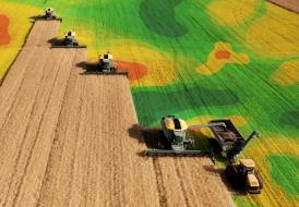
Remote Sensing (RS) Technique
- RS is the science of making inferences about material objects from measurements, made at distance, without coming into physical contact with the objects under study.
- The RS system consists of a sensor to collect the radiation and a platform — an aircraft, balloon, rocket, satellite — on which a sensor can be mounted.

Remote sensing is precision farming is used for crop yield modelling, identification of pests and disease infestation, soil moisture estimation, irrigation monitoring, assessment of crop damage, etc.
Geographic Information System (GIS)
- The GIS is a computerised data storage and retrieval system, which can be used to manage and analyse spatial data relating crop productivity and agronomic (study of crops and the soils) factors.
- It can integrate all types of information and interface with other decision support tools.
- GIS can display analysed information in maps that allow better understanding of interactions among yield, fertility, pests, weeds and other factors, and decision-making based on such spatial relationships.
Internet of things
- The computers and low latency internet (5G) are the most important components in precision farming as they are main source of information processing and gathering.
Future strategy
- Precision farming is practised in developed countries and it not yet practically adoptable in developing countries like India.
- Future strategy for adoption of precision agriculture in India should consider the problem of
- land fragmentation,
- lack of highly sophisticated technical centres for precision agriculture,
- specific software for precision agriculture,
- poor economic condition of the farmers, etc.
Paid users can download this content in PDF & DOC formats from PMF STORE (August Agricluture Related Current Affairs)



![PMF IAS Environment for UPSC 2022-23 [paperback] PMF IAS [Nov 30, 2021]…](https://pmfias.b-cdn.net/wp-content/uploads/2024/04/pmfiasenvironmentforupsc2022-23paperbackpmfiasnov302021.jpg)
