
India-Nepal Border Dispute
- Context (IE): Nepal’s cabinet decided to put a map on its Rs 100 currency note showing certain areas administered by India in Uttarakhand as part of its territory.
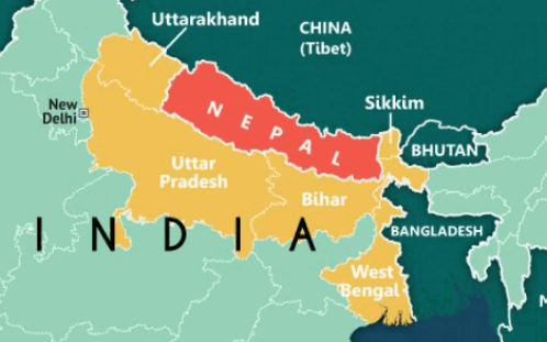
India-Nepal Border
Credit: Maps of India
|
History of India-Nepal Border Dispute
- Nepal surrendered a part of its western territory with the Treaty of Sugauli, signed between the British East India Company and Nepal in 1816, at the end of the Anglo-Nepalese War of 1814-16 after its forces were defeated by the British East India Company.
- The subsequent Sugauli treaty defined the origin of the Kali River as Nepal’s border point with India. The dispute is mainly due to the varying interpretations of the river’s origin and its various tributaries that cut through the mountains.
- The maps issued by the British Surveyor General of India in 1819, 1821, 1827, and 1856 showed the Kali River as originating in Limpiadhura.
- In 1920-21, Kali was shown as a stream originating from a temple site and joining the main stream about a kilometre downstream.
- However, the last map issued by the British before they left India in 1947 showed the initial position of the Kali River originating in Limpiadhura.
- The villages in this area were covered by the Nepal government census until 1962, and the people paid land revenue to the government in Kathmandu. However, the situation changed after the Indo-China War of 1962.
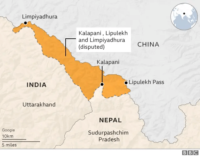
Credit: BBC
Differing views on the source of Kali River
Nepal’s Claim
- Nepal shows the Kali River about 16 kilometers northwest of Kalapani at Limpiyadhura in the Zanskar range of the Himalayas. Thus, the entire stretch starting from Limpiyadhura, including Kalapani and Lipulekh, belongs to Nepal.
Kalapani area
Lipulekh
|
India’s Claim
- India argues that the River Kali originated from a smaller rivulet named Pankhagad, lying on the southern portion of Kalapani, and the subsequent ridge on the eastern part of this area is the true border, therefore making the territory part of India.
Learn in detail about India-Nepal Relations.


