
Earthquakes in Delhi NCR Region, Earthquake Microzoning
HT | Prelims + Mains | GS1 > Important Geophysical phenomena such as earthquakes, Tsunami, etc.
Basics: ‘Fault’ in Geology | Earthquakes | Richter Magnitude Scale
- Context: The National Capital Region (NCR) has witnessed more than 20 earthquakes since April.
- Experts say that these low-intensity earthquakes are a sign that a major earthquake is due for the Delhi-NCR.
- While others believe that these earthquakes are reducing the chances of a major earthquake in the region.
Why so many earthquakes in Delhi NCR Region?
- New Delhi experienced its seventh earthquake in just two months.
- They were all minor, with magnitudes of less than 5.
- Studies have indicated that the Indian plate is still moving into the Asian plate at 5-6 cm per year.
- The consequences of this motion can be observed in the form of ongoing mountain formation.
- The crust has deformed under the Himalaya in such a way that there is a tremendous amount of strain.
- The strain will be able to release if rocks can find some room to shift, move around or even break apart.
- This slow release of tension is what Delhi’s seismic zone is experiencing in the form of minor earthquakes.
- If the crust in this part can slowly release all its tension, there would not have to be a megaquake in the future since there is no accumulation of energy/strain.
- Also, Delhi is closer to multiple faults (Faults are the regions of seismic activities) such as:
- Mahendragarh-Dehradun Fault (MDF),
- Sohna Fault (SF) &
- Mathura Fault (MF)

Is it an Indication of Higher magnitude Earthquake?
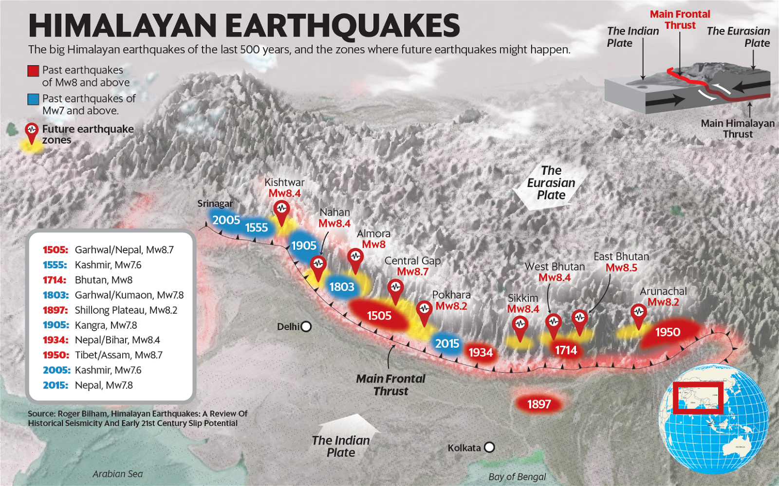
- A ~500 km long ‘Central Himalayan seismic gap’ in northwest India that has not experienced a very large earthquake in the past 200-500 years.
- A seismic gap refers to the portion of a fault that hasn’t experienced quakes in a while though it should have, indicating it’s building strain that it could later release in one large burst.
- Since there will be an accumulation of strain/energy the higher magnitude energy is released at once.
- The last time the Central Himalayan gap (CHG) experienced a quake was in 1803, & before that in 1505.
Delhi standing on danger line due to haphazard development
- Delhi has developed in a very clumsy way.
- The construction of colonies here is quite dense.
- Also, there is a lot of illegal construction in Delhi.
- Two-thirds of the capital’s population live in illegally constructed houses.
- Areas on the banks of the Yamuna in Delhi come under the maximum danger.
Monitoring and Preparation?
- National Seismological Network (NSN) is being operated & maintained by National Seismological Centre (NCS), Ministry of Earth Sciences.
- The seismic network in Delhi & surroundings was strengthened by deploying 11 temporary additional stations covering the known faults in the region to precisely locate the earthquakes & their aftershocks.
- Data from these stations are received in near real-time & used for locating the micro & small earthquakes in the region.
- The expanded network has improved the accuracy of the epicentre location to ~2 km.
- A geophysical survey, namely, Magneto-telluric (MT) is also being conducted over the Delhi region.
- Magneto-telluric (MT) is a geophysical method which uses natural time variation of the Earth’s magnetic & electric fields to understand geological (underground) structure & processes.
- Micro zoning has been done in Delhi & the city is divided into nine parts according to the intensity of quakes.
- Among them, three areas, including densely populated Yamunapar, are the most dangerous.
- Five zones are medium risk, one zone is safe.
What is Earthquake Microzoning?
- Micro zoning means micro classification.
- In this, the surface structure of the ground is investigated.
- Soil samples are collected by drilling into the ground every 200 to 500 meters in the field & after scientific investigation it is decided how sensitive the location is.
- For example, if the building is built on a damp surface, i.e., on the ridge area or on any soil that absorbs water for a long time, then the danger is greater.
- On the other hand, where the soil is dry or sandy, or the rocks are below, it has different effects.
Earthquake Zones (Seismic Zones) of India
- According to the risk of earthquake, the country is divided into four parts, zone-2, zone-3, zone-4 & zone five.

- Of these, the least threatened is Zone 2 & the highest risked is Zone-5.
- North-East, Jammu & Kashmir, Uttarakhand & parts of Himachal Pradesh fall under Zone-5.
- Delhi falls in Zone-4, central India falls under relatively low danger zone of Zone-3, while most of the south falls in Zone-2 with limited danger, but it is a thicker classification.
- There are some areas in Delhi which can be as dangerous as Zone-5.
- Thus, there may be many places in the southern states which may be hazardous like zone-4 or zone-5.


