
India’s Meteorological Satellites
- Context (TH): India’s weather monitoring and warning services have been strengthened by satellites such as Kalpana-1, INSAT-3A, INSAT-3D, and INSAT-3DR.
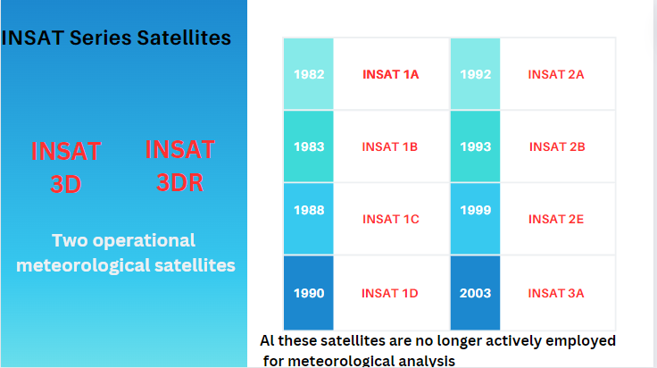
Satellites for Monitoring Weather in India
Indian National Satellite System (INSAT)
- The INSAT is a group of multipurpose geostationary satellites.
- It is designed to provide various services, including telecommunications, broadcasting, meteorology, and search and rescue operations.
- INSAT-I was launched in 1982, followed by INSAT-II in 1983 and INSAT-III in 1988.
- At present, there are two operational meteorological satellites; INSAT-3D & INSAT-3DR.
- India gets weather updates every 15 minutes through INSAT-3D & 3DR weather satellites.

INSAT-3D
- Launched in July 2013, owned and operated by ISRO.
- INSAT-3D carries two instruments, INSAT-3D imager and INSAT sounder.
- The INSAT-3D imager aims to provide accurate and higher-resolution meteorological observations.
- The INSAT sounder is a radiometer. It was developed by ISRO specifically for the geostationary INSAT series.
- It aims to measure temperature and humidity profiles for analysis of cloud cover and meteorological predictions.
- The mission and its applications involve technical and scientific cooperation between India and the USA.
INSAT-3DR
- Launched in September 2016, it is the successor to INSAT-3D.
- INSAT-3DR carries two instruments: the INSAT-3DR imager and the INSAT-3DR sounder.
- The INSAT-3DR imager is a multispectral optical radiometer capable of image generation in six bands.
- Visible (VIS), Short Wave Infrared (SWIR), Mid Wave Infrared (MWIR), Water Vapour (WV), Thermal Infrared-1, -2 (TIR- 1/2).
- It aims to provide information on various parameters, namely outgoing longwave radiation, SST (Sea Surface Temperature), snow cover and cloud motion.
OCEANSAT (1,2,3)
- It is a series of Indian Earth observation satellites designed to monitor ocean-related parameters.
- It is part of the Indian Remote Sensing (IRS) satellite program.
- These observations contribute to studies related to marine biology, fisheries, and climate research.
Saral
- The Satellite with ARGOS and ALTIKA (SARAL) is a joint Indo-French satellite mission for oceanographic studies.
- ALTIKA: Ka-band Altimeter
- ARGOS: Data Collection System
- SARAL performs altimetric measurements designed to study ocean circulation and sea surface elevation.
- It is part of the Indian Remote Sensing (IRS) satellite program.
Megha Tropiques
- It is an Indo-French Earth Observation Satellite which was launched in October 2011 to carry out tropical weather and climate studies.
- The main objective of this mission is to understand the life cycle of convective systems that influence tropical weather and climate.
- It is part of the Indian Remote Sensing (IRS) satellite program.
Kalpana-1
- Kalpana-1 is the first dedicated meteorological satellite launched by the ISRO using a Polar Satellite Launch Vehicle.
- The satellite initially known as MetSat-1, was renamed to Kalpana-1 in memory of Kalpana Chawla.
- MetSat-1 is a precursor to the future INSAT system that will have separate satellites for meteorology and telecommunication.
- it has been decommissioned since 2017.
|


