PMF IAS Current Affairs A Z

NavIC (Navigation with Indian Constellation)

PMF IAS Current Affairs A Z for UPSC IAS and State PCS
  • Context (TOI): ISRO is working to make NavIC (Navigation with Indian Constellation) easily accessible to civilians.

What is NavIC (Navigation with Indian Constellation)?

  • NavIC, also known as the Indian Regional Navigation Satellite System (IRNSS), is an independent, stand-alone navigation satellite system developed by ISRO.
  • It has been in operation since 2018.
  • It covers India and a region up to 1,500 km beyond Indian boundaries.
  • It consists of a constellation of 7 satellites located at 36,000 km (approx.) above the Earth.
  • PSLV was used to place the IRNSS satellite constellation in orbit.

NavIC (Navigation with Indian Constellation)

  • Geosynchronous Orbit: It synchronises with the rotation of the earth. It can be positioned anywhere around the earth.
  • Geostationary Orbit: It falls in the same category as geosynchronous orbits but lies on the same plane as the equator.
  • NavIC provides two types of services:
    1. Standard Positioning Service (SPS): Provided to all the users
    2. Restricted Service (RS): Encrypted service provided only to the authorised users (like the military)
  • It has a position accuracy of better than 20 m.

Applications of NavIC

Applications of NavIC

Benefits of NavIC

  • Strategic autonomy: NavIC will cut our dependence on navigation systems operated by other countries, which can be critical during emergencies, natural calamities, or war. For example, the US government denied GPS access to India during Kargil War.
  • Customised to Indian needs: As an indigenous system, NavIC is designed keeping in mind Indian topography and landscapes.
  • High accuracy: Offers better positioning accuracy (~5 meters) within its coverage area compared to global systems for regional users.

Challenges

  • Some alterations must be made to smartphones to make them NavIC compactible.
  • Smartphone manufacturers claim that it will increase the average selling price of phones.

Difference Between NavIC and GPS

Aspect NavIC  GPS (Global Positioning System)
Developed by Indian Space Research Organisation (ISRO) United States Department of Defense
Coverage Area India and surrounding region up to 1,500 km Global coverage
Constellation Size 7 satellites (3 in geostationary orbit and 4 in geosynchronous orbit) 31 operational satellites (as of current status)
Accuracy ~5 meters over India and nearby regions ~20 meters globally for civilian use
Frequency Bands L5 and S-band L1, L2, and L5 bands
Primary Purpose Regional navigation for civilian and military applications Global navigation for civilian, commercial, and military use
  • There are 4 Global Navigation Systems:
    1. Global Positioning System (GPS) from the U.S.
    2. Global Navigation Satellite System (GLONASS) from Russia
    3. Galileo from European Union
    4. BeiDou from China
  • There are 2 Regional Navigation Systems:
    1. NavIC from India 
    2. Quasi-Zenith Satellite System (QZSS) from Japan
  • To make NavIC truly “global” like GPS, Medium Earth Orbit satellites are needed to be added.
    • Medium Earth Orbit (MEO): It occupies a space between Geosynchronous Orbit (GEO) and Low Earth Orbit (LEO), or about 250-2,000 km from Earth.

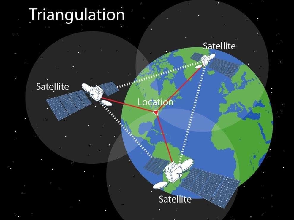
More information on Satellite Orbits: Kepler’s laws, Satellite Orbits, Launch Vehicles PSLV & GSLV)

How Do Navigation Systems Work?

  • Satellite Navigation is based on a global network of satellites that transmit radio signals.
  • The working of the navigation system is based on the trilateration & triangulation principle.
    • Triangulation and Trilateration work with line-of-sight
    • Triangulation measures precise angles (not distance)
    • Trilateration measures precise time data to pinpoint a location.

    Trilateration Vs Triangulation Description automatically generated

Source and Credits

Diagram explaining Working of Triangulation Description automatically generated

Source and Credits

Diagram explaining Working of GPS Description automatically generated
Source and Credits

Why are Atomic Clocks Used in GPS and Other Navigation Satellites?

  • Atomic clocks are extremely accurate timekeeping devices that measure time based on the vibrations or oscillations of atoms, typically cesium or rubidium atoms.
  • Rubidium (Rb) clock and cesium (Cs) clocks are two types of atomic clocks. Rubidium clocks are smaller and less costly but slightly less accurate than cesium clocks.
    • Each of NavIC satellites have three rubidium clocks.
  • Atomic clocks are used in GPS and other navigation system because of:
    • Accuracy: Atomic clocks can keep time to within a few billionths of a second per day.
    • Precise: They are very precisean error of only 1 second in up to 100 million years.
    • Consistency: They maintain a consistent and stable time reference over long periods. They are not affected by environmental factors such as temperature, pressure, or humidity.
    • Multiple Satellites: Atomic clocks enable the synchronization of multiple satellites of the system, allowing for a consistent and reliable signal for users on Earth.
  • A GPS receiver measures the distances to satellites using radio signals and uses the highly precise time data from satellites (at least 4) to locate a specific point on the Earth.

Why Does GPS Positioning Require Four Satellites?

  • It takes four GPS satellites to calculate a precise location on the Earth using the GPS: three to determine a position on the Earth, and one to adjust for the error in the receiver’s clock.
  • Explanation: GPS receivers often do not have atomic clocks, so the error of the receiver’s clock is calculated by adding an additional satellite signal into the calculations.
  • Finding a location this way is called trilateration.

Satellite Navigation - GPS - How It Works | Federal Aviation Administration

PMF IAS World Geography Through Maps
PMF IAS Current Affairs A Z for UPSC IAS and State PCS

Newsletter Updates

Subscribe to our newsletter and never miss an important update!

Assured Discounts on our New Products!

Newsletter

Never miss an important update!