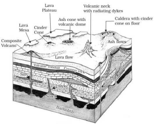
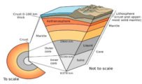
Volcanic landforms are divided into extrusive and intrusive landforms based on whether magma cools within the crust or above the crust.
Rocks formed by the cooling of magma within the crust are called Plutonic rocks.
Rocks formed by the cooling of lava above the surface are called Igneous rocks.
In general, the term ‘Igneous rocks’ is used to refer to all rocks of volcanic origin.
Extrusive and Intrusive volcanic landforms
Extrusive Volcanic Landforms
Extrusive landforms are formed from material thrown out to the surface during volcanic activity.
The materials thrown out include lava flows, pyroclastic debris, volcanic bombs, ash, dust and gases such as nitrogen compounds, sulphur compounds and minor amounts of chlorine, hydrogen and argon.
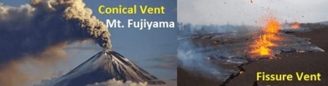
Conical Vent and Fissure Vent
Fissure vent
A fissure vent (volcanic fissure) is a narrow, linear volcanic vent through which lava erupts, usually without any explosive activity.
The vent is often a few meters wide and may be many kilometres long.
Fissure vents are common in basaltic volcanism (shield type volcanoes).
Conical vent
A conical vent is a narrow cylindrical vent through which magma flows out violently.
Conical vents are common in andesitic volcanism (composite or stratovolcano).
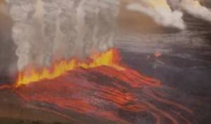
Mid-Ocean Ridges
The system of mid-ocean ridges stretches for more than 70,000 km across all the ocean basins.
The central portion of the mid-ocean ridges experiences frequent eruptions.
The lava is basaltic (less silica and hence less viscous) and causes the spreading of the seafloor.
Composite Type Volcanic Landforms
They are conical or central type volcanic landforms.
Along with andesitic lava, large quantities of pyroclastic material and ashes find their way to the surface.
Andesitic lava along with pyroclastic material accumulates in the vicinity of the vent openings leading to the formation of layers, and this makes the mounts appear as a composite volcano or a stratovolcano (divided into layers).
The highest and most common volcanoes have composite cones.
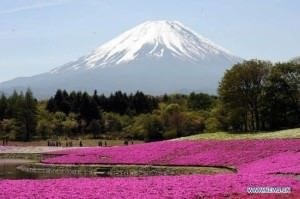
MountStromboli (the Lighthouse of the Mediterranean), Mount Vesuvius, Mount Fuji are examples.
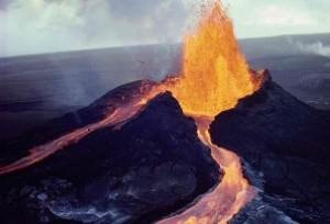
Shield Type Volcanic Landforms
The Hawaiian volcanoes are the most familiar examples.
These volcanoes are mostly made up of basaltic lava (very fluid).
These volcanoes are not steep.
They become explosive if somehow water gets into the vent; otherwise, they are less explosive.
Example: Hawaiian volcanoes Mauna Loa (active shield volcano) and Mauna Kea (dormant shield volcano).
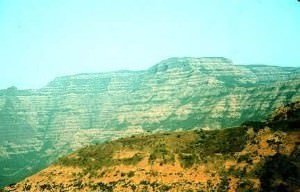
Fissure Type Flood Basalt Landforms (Lava Plateaus)
Sometimes, a very thin magma escapes through cracks and fissures in the earth’s surface and flows after intervals for a long time, spreading over a vast area, finally producing a layered, undulating (wave-like), flat surface.
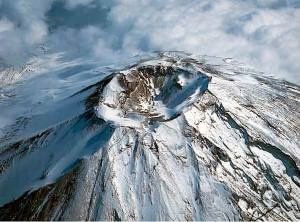
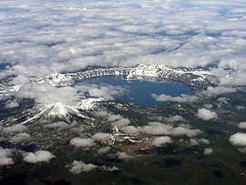
A crater is an inverted cone-shaped vent through which the magma flows out. When the volcano is not active the crater appears as a bowl-shaped depression.
The crater of Mount Fuji, Japan
When water from rain or melted snow gets accumulated in the crater, it becomes a crater lake.
Caldera
In some volcanoes, the magma chamber below the surface may be emptied after volcanic eruptions.
The volcanic material above the chamber collapses into the empty magma chamber, and the collapsed surface appears like a large cauldron-like hollow (tub shaped) called the caldera.
When water from rain or melted snow gets accumulated in the caldera, it becomes a caldera lake (in general, the caldera lakes are also called crater lakes).
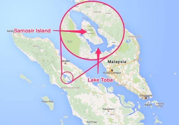
Due to their unstable environments, some crater lakes exist only intermittently. Caldera lakes, in contrast, can be quite large and long-lasting.
For example, Lake Toba (Indonesia) formed after its supervolcanic eruptionaround 75,000 years ago. It is the largest crater lake in the world.
Mount Mazama (Cascade Volcanic Arc, USA) collapsed into a caldera, which was filled with water to form Crater Lake (the literal name of the lake formed by the collapse of Mount Mazama is ‘Crater Lake’!).
Caldera lake of Mount Mazama
A crater lake, in general, could be of volcanic origin (volcanic crater lake, volcanic caldera lake) or due to a meteorite impact (meteor crater or impact crater), or in the crater left by an artificial explosion caused by humans.
Lonar Lake, also known as Lonar crater (Lonar, Buldhana district, Maharashtra) was created by a meteor impact during the Pleistocene Epoch.
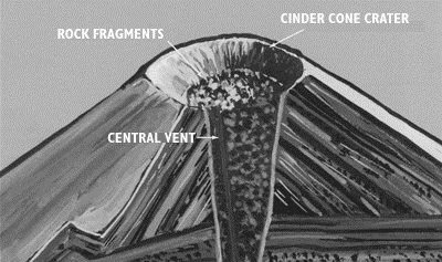
Cinder cone
A cinder cone is a steep circular or oval-shaped hillof loose pyroclastic fragments that have been built around a volcanic vent.
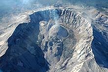
Lava Dome
A lava dome (volcanic dome) is a mound-shaped protrusion (a structure that extends outside the surface) resulting from the slow extrusion (coming out) of viscous lava from a volcano.
In Lava domes, viscous magma piles up around the vent.
The magma does not have enough gas or pressure to escape, although sometime later after sufficient pressure builds up, it may erupt explosively.
Lava dome protruding from a volcanic vent
Pseudo volcanic features
Pseudo volcanic features are certain topographic features that resemble volcanic forms but are of non-volcanic origin. They include meteorite crater, salt plugs, and mud-volcanoes.
Meteorite Craters
Meteorite craters are impact craters that are formed when a meteorite strikes the surface of the earth creating a huge depression.
Salt plug or salt dome
A salt plug is formed when underground salt deposits at high pressure become ductile and pierce through the overlying sediments to create a diapir (a dome-like intrusion forced into brittle overlying rocks.
Salt extrusions may take the form of salt hills which exhibit volcanic crater like features.
Salt structures are impermeable and can lead to the formation of a stratigraphic trap (an impermeable layer capable of retaining hydrocarbons. Structural traps, in contrast, are cracks in faults and folds that can retain hydrocarbons).
Mud-volcanoes
A mud volcano or mud dome is a landform created by the eruption of mud, water and gases.
Mud-volcanoes have a similar shape to other types of volcanoes and contains several cones.
They are usually found near the subduction zones and hot springs.
Other mud volcanoes, entirely of a non-volcanic origin, occur near oil-fields where methane and other volatile hydrocarbon gases mixed with mud force their way upward.
Intrusive Volcanic Landforms
Intrusive landforms are formed when magma cools within the crust.
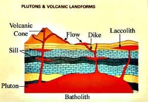
Batholiths
These are large granitic rock bodies formed due to solidification of hot magma inside the earth.
They appear on the surface only after the denudation processes remove the overlying materials.
Batholiths form the core of huge mountains and may be exposed on the surface after erosion.
Laccoliths
These are large dome-shaped intrusive bodies connected by a pipe-like conduit from below.
These are intrusive counterparts of an exposed domelike batholith.
The Karnataka plateau is spotted with dome hills of granite rocks. Most of these, now exfoliated, are examples of laccoliths or batholiths.
Lapolith
As and when the lava moves upwards, a portion of the same may tend to move in a horizontal direction wherever it finds a weak plane. It may get rested in different forms.
In case it develops into a saucer shape, concave to the sky body, it is called Lapolith.
Phacolith
A wavy mass of intrusive rocks, at times, is found at the base of synclines or the top of the anticline in folded igneous strata.
Such wavy materials have a definite conduit to source beneath in the form of magma chambers (subsequently developed as batholiths). These are called the Phacoliths.
Sills
The near horizontal bodies of the intrusive igneous rocks are called sill. The thinner ones are called sheets.
Dykes
When the lava makes its way through cracks and the fissures developed in the land, it solidifies almost perpendicular to the ground.
It gets cooled in the same position to develop a wall-like structure. Such structures are called dykes.
These are the most commonly found intrusive forms in the western Maharashtra area.
These are considered the feeders for the eruptions that led to the development of the Deccan traps.
Now can you give a list complicated question related to earth quake and volcano
Any volunteer please,
what are ridges formed when laccoliths emerge called
Lonar in Maharashtra is formed by meteor impact. How can it be caldera lake? Please explain sir. And excellent notes sir.
sss
lonar lake is not a volcanic lake……..even lkg kids know such silly facts
I just want to print ur pdfpaid notes
I want how many pages does it contain
My eyes are straining in digital platforms
If I know I will purchase definitely
Pls reply me sir
Very useful
Unparallel,indeed.
Congratulations sir Infact I love the flow of the content


fantastic notes prepared by u
thank you for this guys,its helpful.
Now can you give a list complicated question related to earth quake and volcano
Any volunteer please,
what are ridges formed when laccoliths emerge called
Lonar in Maharashtra is formed by meteor impact. How can it be caldera lake? Please explain sir. And excellent notes sir.
sss
lonar lake is not a volcanic lake……..even lkg kids know such silly facts
I just want to print ur pdfpaid notes
I want how many pages does it contain
My eyes are straining in digital platforms
If I know I will purchase definitely
Pls reply me sir
Very useful
Unparallel,indeed.
Congratulations sir Infact I love the flow of the content
amazing notes but can i get or print ur notes
tysm