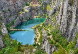
Lakes
- A lake is a body of water of considerable size, localized in a basin, that is surrounded by land apart from a river or other outlet that serves to feed or drain the lake.
- Lakes lie on land and are not part of the ocean, and therefore are distinct from lagoons, and are also larger and deeper than ponds.
- Natural lakes are generally found in mountainous areas, rift zones, and areas with ongoing glaciation.
- Most lakes have at least one natural outflow in the form of a river or stream, which maintain a lake’s average level by allowing the drainage of excess water
- Other lakes are found in endorheic basins. Some lakes do not have a natural outflow and lose water solely by evaporation or underground seepage or both. They are termed endorheic lakes.
- The majority of lakes on Earth are fresh water, and most lie in the Northern Hemisphere at higher latitudes. Canada, Finland and Siberia contain most of the fresh water lakes.
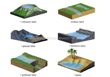
Classification of Lakes
Temporary lakes
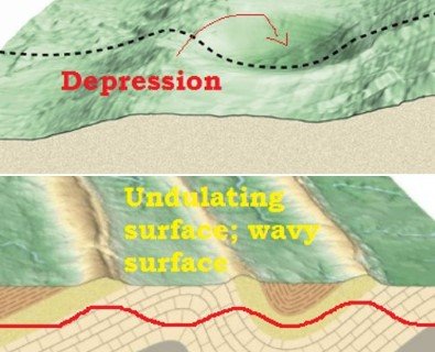
- Lakes may exist temporarily filling up the small depressions of undulating ground after a heavy shower.
- In this kind of lakes, Evaporation > Precipitation.
- Example: Small lakes of deserts.
Permanent lakes
- In this kind of lakes, Evaporation < Precipitation.
- These lakes are deep and carry more water than could ever be evaporated.
- Example: Great Lakes of North America, East African Rift Lakes.
Divergent Boundary – African Rift System Formation
Fresh water lakes
- Most of the lakes in the world are fresh-water lakes fed by rivers and with out-flowing streams e.g. Great Lakes of North America.
Saline lakes
- Salt lakes (also called saline lakes) can form where there is no natural outlet or where the water evaporates rapidly and the drainage surface of the water table has a higher-than-normal salt content.
- Because of the intense evaporation (negative freshwater balance == more water is lost in evaporation than gained from rivers) these lakes are saline.
- Examples of salt lakes include Great Salt Lake, the Aral Sea and the Dead Sea.
- For example the Dead Sea has a salinity (salt content) of 250 parts per thousand, and the Great Salt Lake of Utah, U.S.A. has a salinity of 220 parts per thousand.
- Playas or salt lakes, are a common feature of deserts (recall desert landforms).
Tectonic lakes
- Due to the warping (simple deformation), subsidence (sliding downwards), bending and fracturing (splitting) of the earth’s crust, tectonic depressions occur. (We have studied all these terms in previous posts)
- Such depressions give rise to lakes of immense sizes and depths.
- They include Lake Titicaca, and the Caspian Sea.
Plate Tectonics – Indian Plate Movement – Comparison: Continental Drift – See Floor Spreading – Plate Tectonics
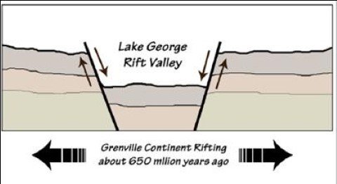
Rift valley lakes
- A rift valley is formed when two blocks of earth move apart letting the ‘in between’ block slide downwards. Or, it’s a sunken land between two parallel faults.
- Rift valleys are deep, narrow and elongated. Hence the lakes formed along rift valleys are also deep, narrow and very long.
- Water collects in troughs (Valley in the rift) and their floors are often below sea level.
- The best known example is the East African Rift Valley which runs through Zambia, Malawi, Tanzania, Kenya and Ethiopia, and extends along the Red Sea to Israel and Jordan over a total distance of 3,000 miles.
- It includes such lakes as Lakes Tanganyika, Malawi, Rudolf, Edward, Albert, as well as the Dead Sea 1,286 feet below mean sea level, the world’s lowest lake.
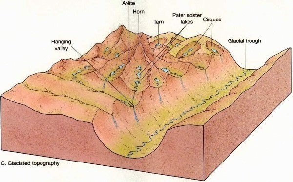
Cirque lakes or tarns
- Cirque is a hollow basin cut into a mountain ridge. It has steep sided slope on three sides, an open end on one side and a flat bottom.
- When the ice melts, the cirque may develop into a tarn lake.
Glacial Landforms – Erosional and Depositional
Rock-hollow lakes
- The advance and retreat of glaciers can scrape depressions in the surface where water accumulates; such lakes are common in Scandinavia, Patagonia, Siberia and Canada.
- These are formed by ice-scouring (eroding) when ice sheets scoop out (dig) hollows on the surface.
- Such lakes of glacial origin are abundant in Finland – Land of Lakes. It is said that there are over 35,000 glacial lakes in Finland.
Lakes due to morainic damming of valleys
- Valley glaciers often deposit morainic debris across a valley so that lakes are formed when water accumulates behind the barrier.
Crater and caldera lakes
- During a volcanic explosion the top of the cone may be blown off leaving behind a natural hollow called a crater.
- This may be enlarged by subsidence into a caldera.
- In dormant or extinct volcanoes, rain falls straight into the crater or caldera which has no superficial outlet and forms a crater or caldera lake.
- Examples: Lonar in Maharashtra and Krakatao in Indonesia.
Others are Lava-blocked lakes and Lakes due to subsidence of a volcanic land surface.
Volcanic Landforms – Extrusive and Intrusive
Karst lakes
- The solvent action of rain-water on limestone carves out solution hollows. When these become clogged with debris lakes may form in them.
- The collapse of limestone roofs of underground caverns may result in the exposure of long, narrow- lakes that were once underground.
Karst Landforms – Cavern, Bogas, Stalactite, Stalagmite
Wind-deflated lakes
- The winds in deserts creates hollows. These may reach ground water which seeps out forming small, shallow lakes. Excessive evaporation causes these to become salt lakes and playas. Example: Great Basin of Utah, U.S.A.
Lakes due to river deposits
- Ox-bow lake, e.g. those that occur on the flood-plains of Lower Mississippi, Lower Ganges etc..
Fluvial Depositional Landforms – Alluvial Fan – Levee – Delta Types
Lakes due to Marine deposits
- Also called Lagoons.
- Example: Lake Chilka
Marine Landforms – Erosional and Depositional – Coastines
Lakes due to damming of water
- Lakes formed by these processes are also known as barrier lakes. Landslides, avalanches may block valleys so that rivers are dammed. Such lakes are short-lived.
- Example: Lakes that are formed in Shiwaliks (Outer Himalayas). Dehradun (all Duns) were lakes few centuries ago.
Man-made lakes
- Besides the natural lakes, man has now created artificial lakes by erecting a concrete dam across a river valley so that the river water can be kept back to form reservoirs.
- Example: Lake Mead above the Hoover Dam on the Colorado River, U.S.A.
- Man’s mining activities, e.g. tin mining in West Malaysia, have created numerous lakes. Inland fish culture has necessitated the creation of many fishing-lakes.
Lakes and Man
- In countries where they are found in abundance, such as Finland, Canada, U.S.A., Sweden and the East African states, lakes are used as inland waterways.
Means of communication
- Large lakes like the Great Lakes of North America provide a cheap and convenient form of transport for heavy and bulky goods such as coal, iron, machinery, grains and timber.
- The Great Lakes-St. Lawrence waterways penetrate more than 1,700 miles into the interior. They are thus used as the chief arteries of commerce.
Economic and industrial development
- The Great Lakes-St. Lawrence waterways were responsible for the development of the interior wheat farms and lakeside industries.
Water storage
- Example: Kolleru lake in Andhra Pradesh.
Hydro-electric power generation
- Artificial lakes like Hirakud.
Agricultural purposes
- Many dams are built across artificial lakes.
- Bhakra Nangal Dam. Its reservoir, known as the “Gobind Sagar Lake” and Hirakud Dam (Odisha) on the Mahanadi in India.
Regulating river flows
- Hoover Dam on the River Colorado and the Bhakra and Nangal Dams on the Sutlej in India.
- The Hirakud dam was originally conceived as a flood control measure. But the project is criticized for doing more damage than good.
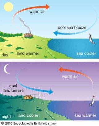
Moderation of climate
- Land and see breeze (we will see this in future posts).
Source of food
- Many large lakes have important supplies of protein food in the form of freshwater fish. Sturgeon is commercially caught in the Caspian Sea, salmon and sea trout in the Great Lakes.
Source of minerals
- Salt lakes provide valuable rock salts. In the Dead Sea, the highly saline water is being evaporated and produces common salt. Borax is mined in the salt lakes of the Mojave Desert.
Tourist attraction and health resorts
- Lake Chilka, Leh, Dead Sea etc..
No lake is permanent over geologic time
- Lakes are only temporary features of the earth’s crust; they will eventually be eliminated by the double process of draining and silting up.
- The process of lake elimination may not be completed within our span of life, it takes place relatively quickly in terms of geological time.
Sources: Certificate Physical and Human Geography [Amazon & Flipkart], Wikipedia